 |
|
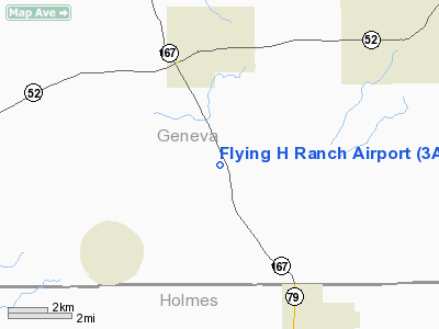
Location
& QuickFacts
|
FAA Information Effective: |
2007-01-18 |
|
Airport
Identifier: |
3AL1 |
|
Airport
Status: |
Operational |
|
Longitude/Latitude: |
085-41-07.0000W/31-03-01.5000N
-85.685278/31.050417 (Estimated) |
|
Elevation: |
264 ft / 80.47 m (Estimated) |
|
Land: |
0
acres |
|
From
nearest city: |
3 nautical miles S of Hartford, AL |
|
Location: |
Geneva County, AL |
|
Magnetic Variation: |
02W (1995) |
Owner
& Manager
|
Ownership: |
Privately owned |
|
Owner: |
J.p. Holman |
|
Address: |
Route 3, Box 751
Hartford, AL 36344 |
|
Phone number: |
205-588-2132 |
|
Manager: |
J.p. Holman |
|
Address: |
Route 3, Box 751
Hartford, AL 36344 |
|
Phone number: |
205-588-2132 |
Airport
Operations and Facilities
|
Airport Use: |
Private |
|
Segmented
Circle: |
No |
|
Control
Tower: |
No |
|
Sectional
chart: |
New Orleans |
|
Region: |
ASO - Southern |
|
Boundary
ARTCC: |
ZJX - Jacksonville |
|
Tie-in
FSS: |
ANB - Anniston |
|
FSS
Toll Free: |
1-800-WX-BRIEF |
|
Runway Information
Runway 06/24
|
Dimension: |
1800 x 150 ft / 548.6 x 45.7 m |
|
Surface: |
TURF, |
|
|
Runway 06 |
Runway 24 |
|
Traffic
Pattern: |
Left |
Left |
|
Radio Navigation
Aids
|
ID |
Type |
Name |
Ch |
Freq |
Var |
Dist |
|
OZ |
NDB |
Ruckr |
|
212.00 |
00E |
12.5 nm |
|
BKK |
NDB |
Tri County |
|
275.00 |
02W |
12.7 nm |
|
LOR |
NDB |
Lowe |
|
269.00 |
03W |
18.9 nm |
|
HYE |
NDB |
Hanchey |
|
221.00 |
00E |
19.1 nm |
|
BVG |
NDB |
Boll Weevil |
|
352.00 |
03E |
23.0 nm |
|
SMY |
NDB |
Soyya |
|
329.00 |
02W |
26.0 nm |
|
JUY |
NDB |
Judd |
|
264.00 |
02W |
39.4 nm |
|
XNE |
NDB |
Spring Hill |
|
281.00 |
00E |
40.9 nm |
|
XBR |
NDB |
Brantley |
|
410.00 |
00E |
43.8 nm |
|
FYL |
VOR |
Tri County |
|
108.40 |
08W |
13.1 nm |
|
EDN |
VOR |
Enterprise |
|
116.60 |
03W |
18.5 nm |
|
HEY |
VOR |
Hanchey |
|
110.60 |
02E |
19.5 nm |
|
UIA |
VOR |
Andalusia |
|
110.20 |
00E |
39.5 nm |
|
OZR |
VOR/DME |
Cairns |
049X |
111.20 |
02E |
13.3 nm |
|
RRS |
VORTAC |
Wiregrass |
053X |
111.60 |
02E |
19.2 nm |
|
MAI |
VORTAC |
Marianna |
087X |
114.00 |
00E |
33.0 nm |
Remarks
Based
Aircraft
|
Aircraft
based on field: |
2 |
|
Single
Engine Airplanes: |
2 |
Flying H Ranch Airport
Address:
Geneva County, AL
Tel:
205-588-2132
Images
and information placed above are from
http://www.airport-data.com/airport/3AL1/
We
thank them for the data!
| General
Info |
| Country |
United
States |
| State |
ALABAMA
|
| FAA ID |
3AL1
|
| Latitude |
31-03-01.500N
|
| Longitude |
085-41-07.000W
|
| Elevation |
264 feet
|
| Near City |
HARTFORD
|
We don't guarantee the information is fresh and accurate. The data may
be wrong or outdated.
For more up-to-date information please refer to other sources.
|
|


