 |
|
Florala Municipal Airport |
| Florala Municipal Airport |
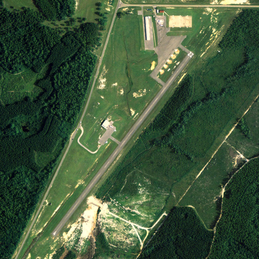 |
| NAIP aerial image, 20 August 2006 |
| IATA: none – ICAO: none – FAA LID: 0J4 |
| Summary |
| Airport type |
Public |
| Owner |
City of Florala |
| Serves |
Florala, Alabama |
| Elevation AMSL |
314 ft / 96 m |
| Coordinates |
31°02′33″N 086°18′42″W / 31.0425°N 86.31167°W / 31.0425; -86.31167 |
| Runways |
| Direction |
Length |
Surface |
| ft |
m |
| 4/22 |
3,197 |
974 |
Asphalt |
| Statistics (2007) |
| Aircraft operations |
21,940 |
| Source: Federal Aviation Administration |
Florala Municipal Airport (FAA LID: 0J4) is a city-owned public-use airport located 3 nautical miles (6 km) northwest of the central business district of Florala, a city in Covington County, Alabama, United States. According to the FAA's National Plan of Integrated Airport Systems for 2009–2013, it is categorized as a general aviation facility.
Facilities and aircraft
Florala Municipal Airport covers an area of 88 acres (0.14 sq mi; 0.36 km), and contains one runway designated 4/22 that is 3,197 x 75 feet (974 x 23 meters) with asphalt pavement. For the 12-month period ending June 19, 2007, the airport had 21,940 general aviation/military aircraft operations.
The above content comes from Wikipedia and is published under free licenses – click here to read more.
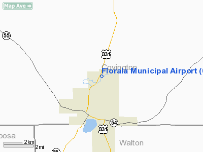
Location
& QuickFacts
|
FAA Information Effective: |
2007-01-18 |
|
Airport
Identifier: |
0J4 |
|
Airport
Status: |
Operational |
|
Longitude/Latitude: |
086-18-41.6200W/31-02-32.9050N
-86.311561/31.042474 (Estimated) |
|
Elevation: |
314 ft / 95.71 m (Surveyed) |
|
Land: |
88
acres |
|
From
nearest city: |
3 nautical miles NE of Florala, AL |
|
Location: |
Covington County, AL |
|
Magnetic Variation: |
00E (1985) |
Owner
& Manager
|
Ownership: |
Publicly owned |
|
Owner: |
City Of Florala |
|
Address: |
Po Box 351
Florala, AL 36442 |
|
Phone
number: |
334-858-3612 |
|
Manager: |
Wiregrass Airplane Co Inc
JOHN KILMER, MANAGER. |
|
Address: |
Rt 2 Box 37
Florala, AL 36442 |
|
Phone number: |
334-858-6173 |
Airport
Operations and Facilities
|
Airport Use: |
Open to public |
|
Wind
indicator: |
Yes |
|
Segmented
Circle: |
No |
|
Control
Tower: |
No |
|
Lighting
Schedule: |
DUSK-DAWN |
|
Beacon
Color: |
Clear-Green (lighted land airport) |
|
Landing
fee charge: |
No |
|
Sectional
chart: |
New Orleans |
|
Region: |
ASO - Southern |
|
Boundary
ARTCC: |
ZJX - Jacksonville |
|
Tie-in
FSS: |
ANB - Anniston |
|
FSS
on Airport: |
No |
|
FSS
Toll Free: |
1-800-WX-BRIEF |
|
NOTAMs
Facility: |
ANB (NOTAM-d service avaliable) |
|
Federal Agreements: |
N |
Airport
Communications
|
CTAF: |
123.000 |
|
Unicom: |
123.000 |
Airport
Services
|
Fuel available: |
A |
|
Airframe Repair: |
MAJOR |
|
Power Plant Repair: |
MAJOR |
|
Bottled
Oxygen: |
NONE |
|
Bulk
Oxygen: |
LOW |
|
Runway Information
Runway 04/22
|
Dimension: |
3197 x 75 ft / 974.4 x 22.9 m |
|
Surface: |
ASPH, Good Condition |
|
Edge
Lights: |
Medium |
|
|
Runway 04 |
Runway 22 |
|
Longitude: |
086-18-52.3800W |
086-18-30.4100W |
|
Latitude: |
31-02-20.3700N |
31-02-45.4400N |
|
Elevation: |
288.00
ft |
314.00
ft |
|
Traffic
Pattern: |
Left |
Left |
|
Markings: |
Basic, Good Condition |
Basic, Good Condition |
|
Obstruction: |
24 ft trees, 800.0 ft from runway, 25:1 slope
to clear |
58 ft trees, 1190.0 ft from runway, 17:1 slope
to clear |
|
Radio Navigation
Aids
|
ID |
Type |
Name |
Ch |
Freq |
Var |
Dist |
|
JUY |
NDB |
Judd |
|
264.00 |
02W |
16.3 nm |
|
BVG |
NDB |
Boll Weevil |
|
352.00 |
03E |
24.5 nm |
|
OZ |
NDB |
Ruckr |
|
212.00 |
00E |
27.8 nm |
|
XBR |
NDB |
Brantley |
|
410.00 |
00E |
31.2 nm |
|
LOR |
NDB |
Lowe |
|
269.00 |
03W |
34.9 nm |
|
BKK |
NDB |
Tri County |
|
275.00 |
02W |
38.4 nm |
|
HYE |
NDB |
Hanchey |
|
221.00 |
00E |
39.2 nm |
|
DTS |
NDB |
Destin |
|
254.00 |
01W |
39.2 nm |
|
XNE |
NDB |
Spring Hill |
|
281.00 |
00E |
42.3 nm |
|
TO |
NDB |
Blood |
|
365.00 |
01W |
48.5 nm |
|
DWG |
TACAN |
Warrington |
002X |
|
00E |
35.6 nm |
|
NSE |
TACAN |
Whiting |
070X |
|
01E |
41.2 nm |
|
NGS |
TACAN |
Santa Rosa |
063X |
|
01E |
41.3 nm |
|
HRT |
TACAN |
Hurlburt |
045X |
|
00E |
41.8 nm |
|
UIA |
VOR |
Andalusia |
|
110.20 |
00E |
16.6 nm |
|
EDN |
VOR |
Enterprise |
|
116.60 |
03W |
25.9 nm |
|
FYL |
VOR |
Tri County |
|
108.40 |
08W |
38.2 nm |
|
HEY |
VOR |
Hanchey |
|
110.60 |
02E |
39.3 nm |
|
OZR |
VOR/DME |
Cairns |
049X |
111.20 |
02E |
33.0 nm |
|
CEW |
VORTAC |
Crestview |
106X |
115.90 |
03E |
23.0 nm |
|
RRS |
VORTAC |
Wiregrass |
053X |
111.60 |
02E |
47.6 nm |
Remarks
- NO
RUNNING LNDGS ON RY/TWY BY SKID EQUIPPED HELICOPTERS.
- DEER
ON & INVOF RY.
- ROTORCRAFT
AND HELICOPTERS AVOID ACFT PAINT HANGAR IN MIDDLE OF FIELD.
Based
Aircraft
|
Aircraft
based on field: |
10 |
|
Single
Engine Airplanes: |
8 |
|
Multi
Engine Airplanes: |
2 |
Operational Statistics
Time Period: 1999-08-16
- 2000-08-14
|
Aircraft
Operations: |
61/Day |
|
General
Aviation Local: |
3.3% |
|
General
Aviation Itinerant: |
5.6% |
|
Military: |
91.2% |
Florala Municipal Airport
Address:
Covington County, AL
Tel:
334-858-3612,
334-858-6173
Images
and information placed above are from
http://www.airport-data.com/airport/0J4/
We
thank them for the data!
| General
Info |
| Country |
United
States |
| State |
ALABAMA
|
| FAA ID |
0J4
|
| Latitude |
31-02-32.905N
|
| Longitude |
086-18-41.620W
|
| Elevation |
314 feet
|
| Near City |
FLORALA
|
We don't guarantee the information is fresh and accurate. The data may
be wrong or outdated.
For more up-to-date information please refer to other sources.
|
|


