 |
|
Enterprise Municipal Airport |
| Enterprise Municipal Airport |
 |
| IATA: ETS – ICAO: KEDN – FAA LID: EDN |
| Summary |
| Airport type |
Public |
| Owner |
City of Enterprise |
| Serves |
Enterprise, Alabama |
| Elevation AMSL |
361 ft / 110 m |
| Coordinates |
31°17′59″N 085°53′59″W / 31.29972°N 85.89972°W / 31.29972; -85.89972 |
| Runways |
| Direction |
Length |
Surface |
| ft |
m |
| 5/23 |
5,080 |
1,548 |
Asphalt |
| Statistics (2010) |
| Aircraft operations |
43,456 |
| Based aircraft |
62 |
| Source: Federal Aviation Administration |
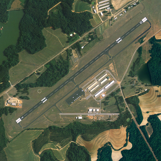
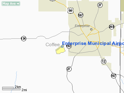
Enterprise Municipal Airport (IATA: ETS, ICAO: KEDN, FAA LID: EDN) is a city-owned public-use airport located three nautical miles (6 km) west of the central business district of Enterprise, a city in Coffee County, Alabama, United States.
Although most U.S. airports use the same three-letter location identifier for the FAA and IATA, Enterprise Municipal Airport is assigned EDN by the FAA and ETS by the IATA.
Facilities and aircraft
Enterprise Municipal Airport covers an area of 90 acres (36 ha) at an elevation of 361 feet (110 m) above mean sea level. It has one runway designated 5/23 with an asphalt surface measuring 5,080 by 100 feet (1,548 x 30 m).
For the 12-month period ending January 25, 2010, the airport had 43,456 aircraft operations, an average of 119 per day: 58% military, 42% general aviation and <1% air taxi. At that time there were 62 aircraft based at this airport: 82% single-engine, 13% multi-engine, 2% helicopter and 3% ultralight.
The above content comes from Wikipedia and is published under free licenses – click here to read more.
Location
& QuickFacts
|
FAA Information Effective: |
2007-01-18 |
|
Airport
Identifier: |
EDN |
|
Airport
Status: |
Operational |
|
Longitude/Latitude: |
085-53-59.5000W/31-17-59.0000N
-85.899861/31.299722 (Estimated) |
|
Elevation: |
364 ft / 110.95 m (Surveyed) |
|
Land: |
90
acres |
|
From
nearest city: |
3 nautical miles W of Enterprise, AL |
|
Location: |
Coffee County, AL |
|
Magnetic Variation: |
03W (2005) |
Owner
& Manager
|
Ownership: |
Publicly owned |
|
Owner: |
Town Of Enterprise |
|
Address: |
P.o.box 311000
Enterprise, AL 36331 |
|
Phone number: |
334-347-1211 |
|
Manager: |
Roger Westerling. |
|
Address: |
867 Aviation Blvd.
Enterprise, AL 36331 |
|
Phone number: |
334-347-1211
EXT 316. |
Airport
Operations and Facilities
|
Airport Use: |
Open to public |
|
Wind
indicator: |
Yes |
|
Segmented
Circle: |
Yes |
|
Control
Tower: |
No |
|
Lighting
Schedule: |
DUSK-DAWN
MIRL RY 05/23 AND VASI RYS 05 & 23 OPER DUSK-2330; AFTER
2330 ACTVT - CTAF. |
|
Beacon
Color: |
Clear-Green (lighted land airport) |
|
Landing
fee charge: |
No |
|
Sectional
chart: |
New Orleans |
|
Region: |
ASO - Southern |
|
Traffic
Pattern Alt: |
800 ft |
|
Boundary
ARTCC: |
ZJX - Jacksonville |
|
Tie-in
FSS: |
ANB - Anniston |
|
FSS
on Airport: |
No |
|
FSS
Toll Free: |
1-800-WX-BRIEF |
|
NOTAMs
Facility: |
ANB (NOTAM-d service avaliable) |
|
Federal Agreements: |
NGY |
Airport
Communications
|
CTAF: |
122.800 |
|
Unicom: |
122.800 |
Airport
Services
|
Fuel available: |
100LLA |
|
Airframe Repair: |
MAJOR |
|
Power Plant Repair: |
MAJOR |
|
Bottled
Oxygen: |
NONE |
|
Bulk
Oxygen: |
NONE |
|
Runway Information
Runway 05/23
|
Dimension: |
5100 x 100 ft / 1554.5 x 30.5 m |
|
Surface: |
ASPH, Good Condition |
|
Edge
Lights: |
Medium |
|
|
Runway 05 |
Runway 23 |
|
Longitude: |
085-54-22.6540W |
085-53-36.4080W |
|
Latitude: |
31-17-43.3600N |
31-18-14.5150N |
|
Elevation: |
346.00
ft |
357.00
ft |
|
Alignment: |
52 |
127 |
|
Traffic
Pattern: |
Left |
Left |
|
Markings: |
Non-precision instrument, Fair Condition |
Non-precision instrument, Fair Condition |
|
VASI: |
2-box on left side |
2-box on left side |
|
Obstruction: |
16 ft trees, 375.0 ft from runway, 150 ft left
of centerline, 10:1 slope to clear |
55 ft tree, 1344.0 ft from runway, 179 ft left
of centerline, 20:1 slope to clear |
|
Radio Navigation
Aids
|
ID |
Type |
Name |
Ch |
Freq |
Var |
Dist |
|
BVG |
NDB |
Boll Weevil |
|
352.00 |
03E |
4.8 nm |
|
OZ |
NDB |
Ruckr |
|
212.00 |
00E |
6.2 nm |
|
LOR |
NDB |
Lowe |
|
269.00 |
03W |
8.8 nm |
|
HYE |
NDB |
Hanchey |
|
221.00 |
00E |
13.4 nm |
|
XNE |
NDB |
Spring Hill |
|
281.00 |
00E |
23.4 nm |
|
JUY |
NDB |
Judd |
|
264.00 |
02W |
25.2 nm |
|
XBR |
NDB |
Brantley |
|
410.00 |
00E |
25.6 nm |
|
BKK |
NDB |
Tri County |
|
275.00 |
02W |
31.0 nm |
|
TO |
NDB |
Blood |
|
365.00 |
01W |
33.6 nm |
|
SMY |
NDB |
Soyya |
|
329.00 |
02W |
43.2 nm |
|
PRN |
NDB |
Persimmon/dcmsnd |
|
359.00 |
00E |
49.4 nm |
|
EDN |
VOR |
Enterprise |
|
116.60 |
03W |
0.3 nm |
|
HEY |
VOR |
Hanchey |
|
110.60 |
02E |
13.4 nm |
|
UIA |
VOR |
Andalusia |
|
110.20 |
00E |
25.3 nm |
|
FYL |
VOR |
Tri County |
|
108.40 |
08W |
31.3 nm |
|
OZR |
VOR/DME |
Cairns |
049X |
111.20 |
02E |
9.1 nm |
|
RRS |
VORTAC |
Wiregrass |
053X |
111.60 |
02E |
24.1 nm |
|
CEW |
VORTAC |
Crestview |
106X |
115.90 |
03E |
49.2 nm |
Remarks
- EXISTED
PRIOR TO MAY 15, 1959.
Based Aircraft
|
Aircraft
based on field: |
70 |
|
Single
Engine Airplanes: |
55 |
|
Multi
Engine Airplanes: |
5 |
|
Ultralights: |
10 |
Operational Statistics
Time Period: 1999-08-17
- 2000-08-15
|
Aircraft
Operations: |
119/Day |
|
General
Aviation Local: |
9.9% |
|
General
Aviation Itinerant: |
32.5% |
|
Military: |
57.6% |
Enterprise Municipal Airport
Address:
Coffee County, AL
Tel:
334-347-1211
Images
and information placed above are from
http://www.airport-data.com/airport/EDN/
We
thank them for the data!
| General
Info |
| Country |
United
States |
| State |
ALABAMA
|
| FAA ID |
EDN
|
| Latitude |
31-17-59.000N
|
| Longitude |
085-53-59.500W
|
| Elevation |
364 feet
|
| Near City |
ENTERPRISE
|
We don't guarantee the information is fresh and accurate. The data may
be wrong or outdated.
For more up-to-date information please refer to other sources.
|
|


