|
|
Dothan Regional Airport
Napier Field

|
 |
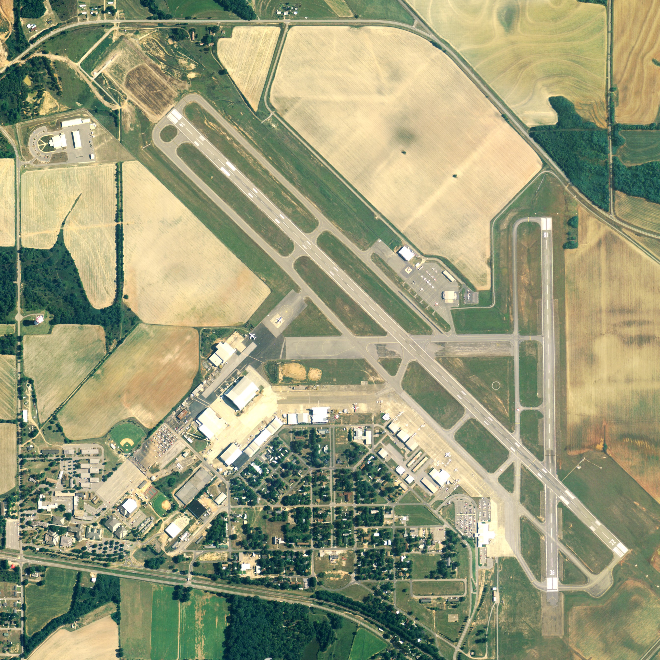
| NAIP aerial image, 24 June 2006 |
| IATA: DHN â ICAO: KDHN â FAA LID: DHN |
| Summary |
| Airport type |
Public |
| Owner |
Dothan - Houston County Airport Authority |
| Serves |
Dothan, Alabama |
| Location |
Dale County, Alabama |
| Elevation AMSL |
401 ft / 122 m |
| Coordinates |
31°19â²16â³N 085°26â²58â³W / 31.32111°N 85.44944°W / 31.32111; -85.44944 |
| Website |
www.flydothan.com |
| Runways |
| Direction |
Length |
Surface |
| ft |
m |
| 14/32 |
8,498 |
2,590 |
Asphalt |
| 18/36 |
5,000 |
1,524 |
Asphalt |
| Statistics (2009) |
| Aircraft operations |
86,319 |
| Based aircraft |
91 |
| Source: Federal Aviation Administration |
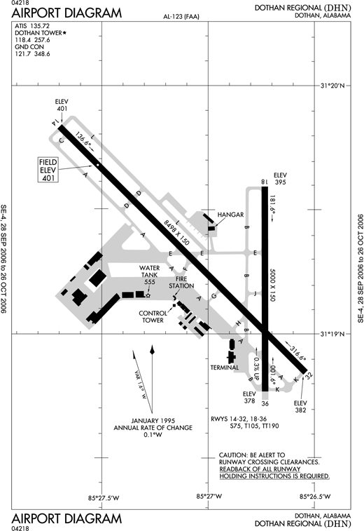 | |
FAA diagram of Dothan Regional Airport |
Dothan Regional Airport (IATA: DHN, ICAO: KDHN, FAA LID: DHN) is a public use airport in the Dale County portion of Dothan, Alabama, located five nautical miles (9 km) northwest of the central business district of Dothan, a city primarily in Houston County, Alabama, United States. It is mostly used for military aviation, but is also served by one commercial airline. History
In 1941 the United States Army Air Corps constructed Napier Field, named in honor of Major Edward L. Napier of Union Springs, Alabama. One of the Army's first flight surgeons, he was killed in a plane crash at McCook Field in Dayton, Ohio.
Napier was assiged to the Southeast Training Center of the Army Air Force Training Command. It was commanded by the 73d Army Air Force Base Unit.
The 29th Flying Training Wing was activated at Napier on 26 December 42. The 2116th (Pilot School, Advanced, Single-Engine) was main operational group at Napier Field. The group flew mostly AT-6 Texans as well as providing advanced & specialized training in single engine aircraft, including P-40 fighters. The first aircraft began operating on the field on October 1, 1941.
On December 20, 1941, the first group of British cadets arrived for training. The first American cadets graduated on July 3, 1942 (42-F). In late May 1945, officers from the Mexican Army began P-40 training at Napier Field.
The field was deactivated on October 31, 1945, and the airfield and its improvements were subsequently made available to the City of Dothan and Houston County under an Agreement in 1946 which was jointly accepted at that time. The airport lands lay dormant for about 20 years and Houston County later turned its share of Napier Field to the City.
In the early 1960s, a complete overhaul of the facility commenced with the old AAF airfield layout being largely dug up and turned into hardcore for new jet runways, buildings and other facilities built for a civilian airport. Dothan Regional Airport opened to commercial activity on February 15, 1965.
Facilities and aircraft
Dothan Regional Airport covers an area of 1,150 acres (465 ha) at an elevation of 401 feet (122 m) above mean sea level. It has two asphalt paved runways: 14/32 is 8,498 by 150 feet (2,590 x 46 m) and 18/36 is 5,500 by 100 feet (1,676 x 30 m).
For the 12-month period ending December 31, 2009, the airport had 86,319 aircraft operations, an average of 236 per day: 58% military, 38% general aviation, 3% scheduled commercial, and 1% air taxi. At that time there were 91 aircraft based at this airport: 53% single-engine, 38% multi-engine, 8% jet and 1% helicopter.
Airlines and destinations
Scheduled passenger service
| Airlines |
Destinations |
| Delta Connection operated by Atlantic Southeast Airlines |
Atlanta |
The above content comes from Wikipedia and is published under free licenses – click here to read more.
Location
& QuickFacts
|
FAA Information Effective: |
2007-01-18 |
|
Airport
Identifier: |
DHN |
|
Airport
Status: |
Operational |
|
Longitude/Latitude: |
085-26-58.6640W/31-19-16.8210N
-85.449629/31.321339 (Estimated) |
|
Elevation: |
401 ft / 122.22 m (Surveyed) |
|
Land: |
1150 acres |
|
From
nearest city: |
5 nautical miles NW of Dothan, AL |
|
Location: |
Dale County, AL |
|
Magnetic Variation: |
01W (1985) |
Owner
& Manager
|
Ownership: |
Publicly owned |
|
Owner: |
Dothan-houston Co Arpt Auth |
|
Address: |
800 Arpt Dr Suite 15
Dothan, AL 36303 |
|
Phone
number: |
334-983-8100 |
|
Manager: |
Art Morris Iii |
|
Address: |
800 Arpt Dr Suite 15
Dothan, AL 36303 |
|
Phone number: |
334-983-8100 |
Airport
Operations and Facilities
|
Airport Use: |
Open to public |
|
Wind
indicator: |
Yes |
|
Segmented
Circle: |
Yes |
|
Control
Tower: |
Yes |
|
Lighting
Schedule: |
DUSK-DAWN
WHEN ATCT CLSD, ACTVT HIRL RY 14/32, PAPI & REIL RY
14 AND MALSR RY 32 - CTAF. HIRL RY 18/36 & VASI RY 18
AVBL BY PRIOR REQ DURG ATTENDED HRS CALL 334-983-8100/8103. |
|
Beacon
Color: |
Clear-Green (lighted land airport) |
|
Landing
fee charge: |
No
MISC: LDG FEE FOR ACFT OVER 12500 LBS. |
|
Sectional
chart: |
New Orleans |
|
Region: |
ASO - Southern |
|
Boundary
ARTCC: |
ZJX - Jacksonville |
|
Tie-in
FSS: |
ANB - Anniston |
|
FSS
on Airport: |
No |
|
FSS
Toll Free: |
1-800-WX-BRIEF |
|
NOTAMs
Facility: |
DHN (NOTAM-d service avaliable) |
|
Certification
type/date: |
I B S 05/1973
48 HR PPR FOR UNSKED ACR OPNS WITH MORE THAN 30 PSGR SEATS
2300-0600 CALL AMGR 334-983-8100. |
|
Federal Agreements: |
NGY3 |
Airport
Communications
|
CTAF: |
118.400 |
|
Unicom: |
122.950 |
Airport
Services
|
Fuel available: |
100LLA |
|
Airframe Repair: |
MAJOR |
|
Power Plant Repair: |
MAJOR |
|
Bottled
Oxygen: |
NONE |
|
Bulk
Oxygen: |
NONE |
|
Runway Information
Runway 14/32
|
Dimension: |
8498 x 150 ft / 2590.2 x 45.7 m |
|
Surface: |
ASPH, Good Condition |
|
Surface
Treatment: |
Saw-cut or plastic Grooved |
|
Pavement
Class: |
34 /F/B/X/T |
|
Weight
Limit: |
Single wheel: 75000 lbs.
Dual wheel: 105000 lbs.
Dual
tandem wheel: 190000 lbs. |
|
Edge
Lights: |
High |
|
|
Runway 14 |
Runway 32 |
|
Longitude: |
085-27-41.9300W |
085-26-32.5890W |
|
Latitude: |
31-19-50.1300N |
31-18-50.7190N |
|
Elevation: |
401.00
ft |
382.00
ft |
|
Alignment: |
127 |
127 |
|
ILS
Type: |
|
ILS |
|
Traffic
Pattern: |
Left |
Left |
|
Markings: |
Precision instrument, Good Condition |
Precision instrument, Good Condition |
|
Crossing
Height: |
34.00
ft |
0.00 ft |
|
VASI: |
2-light PAPI on left side |
|
|
Visual
Glide Angle: |
3.00° |
0.00° |
|
RVR
Equipment: |
|
touchdown |
|
Approach
lights: |
|
MALSR |
|
Runway
End Identifier: |
Yes |
|
|
Obstruction: |
9 ft pole, 590.0 ft from runway, 260 ft right
of centerline, 43:1 slope to clear |
, 50:1 slope to clear |
|
Runway 18/36
|
Dimension: |
5000 x 150 ft / 1524.0 x 45.7 m |
|
Surface: |
ASPH, Good Condition |
|
Pavement
Class: |
30 /F/B/X/T |
|
Weight
Limit: |
Single wheel: 75000 lbs.
Dual wheel: 105000 lbs.
Dual
tandem wheel: 190000 lbs. |
|
Edge
Lights: |
High |
|
|
Runway 18 |
Runway 36 |
|
Longitude: |
085-26-44.0130W |
085-26-43.9970W |
|
Latitude: |
31-19-35.5600N |
31-18-46.0740N |
|
Elevation: |
395.00
ft |
378.00
ft |
|
Alignment: |
127 |
127 |
|
Traffic
Pattern: |
Left |
Left |
|
Markings: |
Non-precision instrument, Good Condition
THR LGTS ARE 30 FT FROM APPROACH END OF RY. |
Non-precision instrument, Good Condition |
|
Crossing
Height: |
26.00
ft |
0.00 ft |
|
VASI: |
4-box on left side |
|
|
Visual
Glide Angle: |
3.00° |
0.00° |
|
Runway
End Identifier: |
Yes |
|
|
Obstruction: |
48 ft trees, 1400.0 ft from runway, 100 ft
left of centerline, 25:1 slope to clear |
80 ft trees, 2050.0 ft from runway, 450 ft
left of centerline, 23:1 slope to clear |
|
Radio Navigation
Aids
|
ID |
Type |
Name |
Ch |
Freq |
Var |
Dist |
|
HYE |
NDB |
Hanchey |
|
221.00 |
00E |
10.6 nm |
|
LOR |
NDB |
Lowe |
|
269.00 |
03W |
15.3 nm |
|
OZ |
NDB |
Ruckr |
|
212.00 |
00E |
19.7 nm |
|
BVG |
NDB |
Boll Weevil |
|
352.00 |
03E |
27.4 nm |
|
BKK |
NDB |
Tri County |
|
275.00 |
02W |
29.3 nm |
|
SMY |
NDB |
Soyya |
|
329.00 |
02W |
29.4 nm |
|
IWJ |
NDB |
Blaak |
|
344.00 |
03W |
33.3 nm |
|
XNE |
NDB |
Spring Hill |
|
281.00 |
00E |
34.6 nm |
|
TO |
NDB |
Blood |
|
365.00 |
01W |
45.4 nm |
|
XBR |
NDB |
Brantley |
|
410.00 |
00E |
45.6 nm |
|
JUY |
NDB |
Judd |
|
264.00 |
02W |
48.3 nm |
|
HEY |
VOR |
Hanchey |
|
110.60 |
02E |
10.9 nm |
|
EDN |
VOR |
Enterprise |
|
116.60 |
03W |
23.3 nm |
|
FYL |
VOR |
Tri County |
|
108.40 |
08W |
30.0 nm |
|
UIA |
VOR |
Andalusia |
|
110.20 |
00E |
48.4 nm |
|
OZR |
VOR/DME |
Cairns |
049X |
111.20 |
02E |
14.6 nm |
|
RRS |
VORTAC |
Wiregrass |
053X |
111.60 |
02E |
2.4 nm |
|
MAI |
VORTAC |
Marianna |
087X |
114.00 |
00E |
36.3 nm |
|
EUF |
VORTAC |
Eufaula |
029X |
109.20 |
02E |
41.2 nm |
Remarks
- MAXIMUM
TWY WIDTH FOR RY 14/32 IS 75 FT.
- RSTD:
USAF NOT AUTHORIZED TO OPER C130 & C135 ACFT ON RY 18/36.
- ARFF
PERSONNEL ON DUTY AT ARPT 24 HRS.
- CAUTION:
MAJ ARPT CONST UFN, CONSULT NOTAM. PILOTS EXER CAUTION IN VCNTY PEMCO
WORLD AIR SERVICES RAMP DUE TO POSSIBLE FOD/OBST ASSOCIATED WITH HGR
CONST.
- ARPT
CONST BEFORE FAA ACT NO AIRSPACE ACTION ON FILE IN AREA OFFICE.
Based
Aircraft
|
Aircraft
based on field: |
91 |
|
Single
Engine Airplanes: |
38 |
|
Multi
Engine Airplanes: |
43 |
|
Jet Engine
Airplanes: |
9 |
|
Ultralights: |
1 |
Major Carriers
Serving This Airport
| Atlantic Southeast Airlines |
100.0% |
Most Popular Destinations
|
Hartsfield - Jackson Atlanta Intl (ATL) |
100.0% |
Most Popular Aircraft
|
N642AS |
4.2% |
| N641AS |
3.9% |
|
N637AS |
3.2% |
| N643AS |
3.2% |
|
N631AS |
3.0% |
| N633AS |
3.0% |
|
N636AS |
2.8% |
| N640AS |
2.8% |
|
N632AS |
2.8% |
| N630AS |
2.1% |
Operational Statistics
Time Period: 2005-01-01
- 2005-12-31
|
Aircraft
Operations: |
245/Day |
|
Commerical: |
5.2% |
|
Air Taxi: |
1.8% |
|
General
Aviation Local: |
21.0% |
|
General
Aviation Itinerant: |
26.4% |
|
Military: |
45.5% |
Dothan Regional Airport
Address:
Dale County, AL
Tel:
334-983-8100
Images
and information placed above are from
http://www.airport-data.com/airport/DHN/
We
thank them for the data!
| General
Info |
| Country |
United
States |
| State |
ALABAMA
|
| FAA ID |
DHN
|
| Latitude |
31-19-16.821N
|
| Longitude |
085-26-58.664W
|
| Elevation |
401 feet
|
| Near City |
DOTHAN
|
We don't guarantee the information is fresh and accurate. The data may
be wrong or outdated.
For more up-to-date information please refer to other sources.
|
|