 |
|
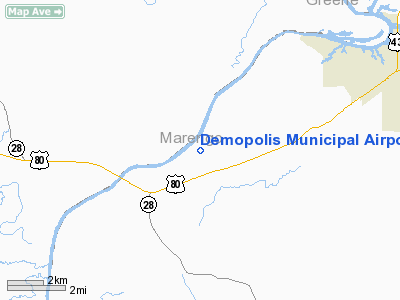
Demopolis Municipal Airport |
|
|
Location
& QuickFacts
|
FAA Information Effective: |
2007-01-18 |
|
Airport
Identifier: |
7A2 |
|
Airport
Status: |
Operational |
|
Longitude/Latitude: |
087-57-14.6300W/32-27-49.7500N
-87.954064/32.463819 (Estimated) |
|
Elevation: |
113 ft / 34.44 m (Surveyed) |
|
Land: |
438 acres |
|
From
nearest city: |
6 nautical miles SW of Demopolis, AL |
|
Location: |
Marengo County, AL |
|
Magnetic Variation: |
01E (1985) |
Owner
& Manager
|
Ownership: |
Publicly owned |
|
Owner: |
City Of Demopolis |
|
Address: |
Po Box 580
Demopolis, AL 36732 |
|
Phone number: |
334-289-0577 |
|
Manager: |
Julian D. Sawyer |
|
Address: |
Po Box 774
Demopolis, AL 36732 |
|
Phone number: |
334-289-0455 |
Airport
Operations and Facilities
|
Airport Use: |
Open to public |
|
Wind
indicator: |
Yes |
|
Segmented
Circle: |
No |
|
Control
Tower: |
No |
|
Lighting
Schedule: |
DUSK-DAWN
ACTVT PAPI RYS 04 & 22 AND MIRL RY 04/22 - CTAF. |
|
Beacon
Color: |
Clear-Green (lighted land airport) |
|
Landing
fee charge: |
No |
|
Sectional
chart: |
Atlanta |
|
Region: |
ASO - Southern |
|
Boundary
ARTCC: |
ZTL - Atlanta |
|
Responsible
ARTCC: |
ZME - Memphis |
|
Tie-in
FSS: |
ANB - Anniston |
|
FSS
on Airport: |
No |
|
FSS
Toll Free: |
1-800-WX-BRIEF |
|
NOTAMs
Facility: |
ANB (NOTAM-d service avaliable) |
|
Federal Agreements: |
NGY3 |
Airport
Communications
|
CTAF: |
122.800 |
|
Unicom: |
122.800 |
Airport
Services
|
Fuel available: |
100LLA |
|
Airframe Repair: |
NONE |
|
Power Plant Repair: |
NONE |
|
Bottled
Oxygen: |
NONE |
|
Bulk
Oxygen: |
NONE |
|
Runway Information
Runway 04/22
|
Dimension: |
5000
x 100 ft / 1524.0 x 30.5 m
20 FT SHOULDERS ON BOTH SIDES OF RY. |
|
Surface: |
ASPH, Good Condition |
|
Weight
Limit: |
Single wheel: 30000 lbs.
Dual wheel: 38000 lbs.
Dual
tandem wheel: 60000 lbs. |
|
Edge
Lights: |
Medium
MIRL SET 85 FT FROM CNTRLN. |
|
|
Runway 04 |
Runway 22 |
|
Longitude: |
087-57-34.4500W |
087-56-54.8100W |
|
Latitude: |
32-27-31.5800N |
32-28-07.9200N |
|
Elevation: |
113.00
ft |
106.00
ft |
|
Alignment: |
43 |
127 |
|
Traffic
Pattern: |
Left |
Left |
|
Markings: |
Basic, Poor Condition
RY 04/22 MARKINGS FADED. |
Basic, Poor Condition |
|
Crossing
Height: |
43.00
ft |
43.00
ft |
|
VASI: |
2-light PAPI on right side |
2-light PAPI on left side |
|
Visual
Glide Angle: |
3.25° |
3.25° |
|
Obstruction: |
51 ft trees, 995.0 ft from runway, 193 ft right
of centerline, 15:1 slope to clear |
24 ft trees, 200.0 ft from runway, 80 ft left
of centerline
+15 FT TREES 0-200 FT FM THLD 185 FT RIGHT; +20 FT TREES 20-200
FT FM THLD 80 FT LEFT. |
|
Radio Navigation
Aids
|
ID |
Type |
Name |
Ch |
Freq |
Var |
Dist |
|
RZO |
NDB |
Marengo |
|
391.00 |
01E |
4.3 nm |
|
EOG |
NDB |
Greensboro |
|
417.00 |
01E |
16.9 nm |
|
BCZ |
NDB |
Choctaw |
|
228.00 |
01E |
22.7 nm |
|
AIV |
NDB |
Aliceville |
|
254.00 |
|
40.8 nm |
|
ME |
NDB |
Savoy |
|
356.00 |
01E |
43.5 nm |
|
NMM |
TACAN |
Meridian |
056X |
|
01E |
30.7 nm |
|
NJW |
TACAN |
Joe Williams |
61Y |
|
01E |
48.9 nm |
|
JYU |
VOR/DME |
Junior |
083X |
113.60 |
01W |
49.4 nm |
|
EWA |
VORTAC |
Kewanee |
085X |
113.80 |
04E |
26.2 nm |
|
MEI |
VORTAC |
Meridian |
117X |
117.00 |
05E |
43.4 nm |
Remarks
- DEER
ON AND INVOF ARPT.
- PAEW
ADJ NORTH SIDE RY 04/22.
Based Aircraft
|
Aircraft
based on field: |
11 |
|
Single
Engine Airplanes: |
10 |
|
Ultralights: |
1 |
Operational Statistics
Time Period: 1999-07-29
- 2000-07-27
|
Aircraft
Operations: |
101/Week |
|
General
Aviation Local: |
14.4% |
|
General
Aviation Itinerant: |
84.2% |
|
Military: |
1.4% |
Demopolis Municipal Airport
Address:
Marengo County, AL
Tel:
334-289-0577, 334-289-0455
Images
and information placed above are from
http://www.airport-data.com/airport/7A2/
We
thank them for the data!
| General
Info |
| Country |
United
States |
| State |
ALABAMA
|
| FAA ID |
7A2
|
| Latitude |
32-27-49.750N
|
| Longitude |
087-57-14.630W
|
| Elevation |
112 feet
|
| Near City |
DEMOPOLIS
|
We don't guarantee the information is fresh and accurate. The data may
be wrong or outdated.
For more up-to-date information please refer to other sources.
|
|


