 |
|
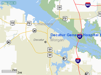
Decatur General Hospital Heliport |
Location
& QuickFacts
|
FAA Information Effective: |
2007-01-18 |
|
Airport
Identifier: |
1AL1 |
|
Airport
Status: |
Operational |
|
Longitude/Latitude: |
086-58-20.0000W/34-35-27.0000N
-86.972222/34.590833 (Estimated) |
|
Elevation: |
588 ft / 179.22 m (Estimated) |
|
Land: |
0
acres |
|
From
nearest city: |
0 nautical miles N of Decatur, AL |
|
Location: |
Morgan County, AL |
|
Magnetic Variation: |
00W (1990) |
Owner
& Manager
|
Ownership: |
Publicly owned |
|
Owner: |
Decatur General Hospital |
|
Address: |
P.o. Box 2239
Decatur, AL 35602 |
|
Phone
number: |
205-552-0055 |
|
Manager: |
R. L. Smith |
|
Address: |
P.o. Box 2239
Decatur, AL 35602-2239 |
|
Phone number: |
205-552-0055 |
Airport
Operations and Facilities
|
Airport Use: |
Private
MEDICAL USE. |
|
Segmented
Circle: |
No |
|
Control
Tower: |
No |
|
Sectional
chart: |
Atlanta |
|
Region: |
ASO - Southern |
|
Boundary
ARTCC: |
ZME - Memphis |
|
Tie-in
FSS: |
ANB - Anniston |
|
FSS
on Airport: |
No |
|
FSS
Toll Free: |
1-800-WX-BRIEF |
|
Runway Information
Helipad H1
|
Dimension: |
51 x 51 ft / 15.5 x 15.5 m |
|
Surface: |
ASPH, |
|
|
Runway H1 |
Runway |
|
Traffic
Pattern: |
Left |
Left |
|
Radio Navigation
Aids
|
ID |
Type |
Name |
Ch |
Freq |
Var |
Dist |
|
CWH |
NDB |
Capshaw |
|
350.00 |
01W |
14.6 nm |
|
CPP |
NDB |
Cole Spring |
|
230.00 |
01W |
15.3 nm |
|
HUA |
NDB |
Redstone |
|
287.00 |
00W |
15.5 nm |
|
GZS |
NDB |
Giles/dcmsnd |
|
375.00 |
00E |
34.0 nm |
|
TNY |
NDB |
Kelso |
|
358.00 |
01W |
38.9 nm |
|
LRT |
NDB |
Lawrenceburg |
|
269.00 |
00E |
41.3 nm |
|
ARF |
NDB |
Saratoga |
|
296.00 |
02W |
42.3 nm |
|
DCU |
VOR/DME |
Decatur |
075X |
112.80 |
01W |
3.8 nm |
|
RQZ |
VORTAC |
Rocket |
059X |
112.20 |
02E |
20.8 nm |
|
MSL |
VORTAC |
Muscle Shoals |
112X |
116.50 |
01E |
26.6 nm |
|
HSV |
VOT |
Huntsville |
|
111.00 |
|
25.5 nm |
Remarks
- PRVDD
APCH/DEP RTE OPS FROM 050-100 DEG; TKOF/LNDG AREA MKD; WIND INDICATOR
MNTND.
Decatur General Hospital Heliport
Address:
Morgan County, AL
Tel:
205-552-0055
Images
and information placed above are from
http://www.airport-data.com/airport/1AL1/
We
thank them for the data!
| General
Info |
| Country |
United
States |
| State |
ALABAMA
|
| FAA ID |
1AL1
|
| Latitude |
34-35-27.000N
|
| Longitude |
086-58-20.000W
|
| Elevation |
588 feet
|
| Near City |
DECATUR
|
We don't guarantee the information is fresh and accurate. The data may
be wrong or outdated.
For more up-to-date information please refer to other sources.
|
|


