 |
|
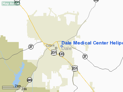
Dale Medical Center Heliport |
Location
& QuickFacts
|
FAA Information Effective: |
2007-01-18 |
|
Airport
Identifier: |
AL87 |
|
Airport
Status: |
Operational |
|
Longitude/Latitude: |
085-37-54.7740W/31-27-05.6080N
-85.631882/31.451558 (Estimated) |
|
Elevation: |
390
ft / 118.87 m (Estimated) |
|
Land: |
8
acres |
|
From
nearest city: |
0 nautical miles S of Ozark, AL |
|
Location: |
Dale County, AL |
|
Magnetic Variation: |
00W (1985) |
Owner
& Manager
|
Ownership: |
Privately owned |
|
Owner: |
Dale Medical Center |
|
Address: |
100 Hospital Ave
Ozark, AL 36360 |
|
Phone
number: |
205-774-2601 |
|
Manager: |
Dale Medical Ctr Maint Dept |
|
Address: |
100 Hospital Ave
Ozark, AL 36360 |
|
Phone number: |
205-774-2601 |
Airport
Operations and Facilities
|
Airport Use: |
Private
MEDICAL USE ONLY. |
|
Wind
indicator: |
Yes |
|
Segmented
Circle: |
No |
|
Control
Tower: |
No |
|
Sectional
chart: |
New Orleans |
|
Region: |
ASO - Southern |
|
Boundary
ARTCC: |
ZJX - Jacksonville |
|
Tie-in
FSS: |
ANB - Anniston |
|
FSS
on Airport: |
No |
|
FSS
Toll Free: |
1-800-WX-BRIEF |
|
Runway Information
Helipad H1
|
Dimension: |
44 x 40 ft / 13.4 x 12.2 m |
|
Surface: |
CONC, |
|
|
Runway H1 |
Runway |
|
Traffic
Pattern: |
Left |
Left |
|
Radio Navigation
Aids
|
ID |
Type |
Name |
Ch |
Freq |
Var |
Dist |
|
HYE |
NDB |
Hanchey |
|
221.00 |
00E |
5.2 nm |
|
LOR |
NDB |
Lowe |
|
269.00 |
03W |
7.9 nm |
|
OZ |
NDB |
Ruckr |
|
212.00 |
00E |
16.5 nm |
|
BVG |
NDB |
Boll Weevil |
|
352.00 |
03E |
19.3 nm |
|
XNE |
NDB |
Spring Hill |
|
281.00 |
00E |
22.4 nm |
|
TO |
NDB |
Blood |
|
365.00 |
01W |
33.2 nm |
|
XBR |
NDB |
Brantley |
|
410.00 |
00E |
34.5 nm |
|
BKK |
NDB |
Tri County |
|
275.00 |
02W |
36.1 nm |
|
JUY |
NDB |
Judd |
|
264.00 |
02W |
39.9 nm |
|
SMY |
NDB |
Soyya |
|
329.00 |
02W |
40.7 nm |
|
IWJ |
NDB |
Blaak |
|
344.00 |
03W |
41.7 nm |
|
HEY |
VOR |
Hanchey |
|
110.60 |
02E |
4.8 nm |
|
EDN |
VOR |
Enterprise |
|
116.60 |
03W |
16.8 nm |
|
FYL |
VOR |
Tri County |
|
108.40 |
08W |
36.7 nm |
|
UIA |
VOR |
Andalusia |
|
110.20 |
00E |
39.9 nm |
|
OZR |
VOR/DME |
Cairns |
049X |
111.20 |
02E |
12.0 nm |
|
RRS |
VORTAC |
Wiregrass |
053X |
111.60 |
02E |
14.4 nm |
|
EUF |
VORTAC |
Eufaula |
029X |
109.20 |
02E |
39.4 nm |
|
MAI |
VORTAC |
Marianna |
087X |
114.00 |
00E |
47.8 nm |
Remarks
- ALL
APPROACHES AND DEPARTURES SHOULD BE CONDUCTED IN AN AREA FROM 180-240
DEG CLKWS USING THE TOUCHDOWN PAD AS CENTER OF A COMPASS ROSE.
- OPNS
ARE CONDUCTED FROM 180-240 DEG, AREA IS MARKED AND WIND INDICATOR IS
MAINTAINED.
Dale Medical Center Heliport
Address:
Dale County, AL
Tel:
205-774-2601
Images
and information placed above are from
http://www.airport-data.com/airport/AL87/
We
thank them for the data!
| General
Info |
| Country |
United
States |
| State |
ALABAMA
|
| FAA ID |
AL87
|
| Latitude |
31-27-05.608N
|
| Longitude |
085-37-54.774W
|
| Elevation |
390 feet
|
| Near City |
OZARK
|
We don't guarantee the information is fresh and accurate. The data may
be wrong or outdated.
For more up-to-date information please refer to other sources.
|
|


