Craig Field Airport in Alabama Alabama airports - Craig Field Airport
Craig Field Airport in Alabama - United States
Alabama Airports
USA Airports
World Airports
Airport photos
Aircraft photos
Spacecraft photos
Earth from airplane
Earth from space
Aviation Articles

Craig Field Airport


For the United States Air Force use of this facility prior to 1977, see Craig Air Force Base
Craig Field
Aerial photo of Craig Field, 30 June 2006
IATA: SEM – ICAO: KSEM – FAA LID: SEM
Summary
Airport type Public
Owner Craig Field Airport & Industrial Authority
Serves Selma, Alabama
Elevation AMSL 166 ft / 50.6 m
Coordinates 32°20′38″N 086°59′16″W / 32.34389°N 86.98778°W / 32.34389; -86.98778
Website www.CraigComplex.com
Runways
Direction Length Surface
ft m
15/33 8,002 2,439 Asphalt/Concrete
Statistics (2006)
Aircraft operations 38,550
Source: Federal Aviation Administration

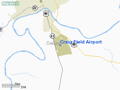
Craig Field (IATA: SEM, ICAO: KSEM, FAA LID: SEM) is a local authority-owned public-use airport located 4 nautical miles (7 km) southeast of the central business district of Selma, a city in Dallas County, Alabama, United States.

DayJet provides an on-demand jet air taxi service from this airport to Tallahassee, Jacksonville, Gainesville, Macon, Savannah, Pensacola, Lakeland/Tampa, Opa-Locka/Miami Dade, Boca Raton, Naples, Sarasota/Bradenton.

Overview

Craig Field covers an area of 1,790 acres (2.797 sq mi; 7.244 km) which contains one runway designated 15/33 is 8,002 x 150 feet (2,439 x 46 meters) asphalt/concrete pavement. For the 12-month period ending September 28, 2006, the airport had 38,550 general aviation aircraft operations.

Although the former USAF air traffic control tower at Craig Field remains standing, as of 2007 it was unmanned and non-operational, with UNICOM being used as a common traffic advisory frequency (CTAF). Both parallel 8,000 foot runways still exist, but only one runway is currently operational while the other remains closed. The Craig VORTAC and the Instrument Landing System (ILS) for the current Runway 33 remain operational on the field. Current aircraft traffic averages approximately 106 daily operations, of which 83% are transient general aviation, 10% military (primarily Navy and USAF aircraft inbound to the L3 Communications/Vertex Aerospace facility) and 7% local general aviation or air taxi.

The former military family housing was sold to individual owners shortly after base closure and has seen significant decay as compared to its previous military occupants.

Multiple civilian government and corporate tenants have taken up residency, to include L3 Communications/Vertex Aerospace (formerly Raytheon Aerospace), which operates an aircraft repair facility at Craig Field primarily focused on supporting Navy T-34C, T-44A, TC-12F and Navy and USAF T-6A aircraft. The former on base elementary school continues to operate as the civilian-run Craig Elementary and the former base golf course continues to operate commercially as the Craig Golf Course and Driving Range. The Alabama Highway Patrol (AHP) also operates both its training academy and its headquarters for AHP's F Troop at Craig.


The above content comes from Wikipedia and is published under free licenses – click here to read more.


Craig Field Airport


Location & QuickFacts

FAA Information Effective:

2005-10-27

Airport Identifier:

SEM

Longitude/Latitude:

086-59-16.0920W/32-20-38.2080N
-86.987803/32.343947 (Estimated)

Elevation:

166 ft / 50.60 m (Surveyed)

Land:

1790 acres

From nearest city:

4 nautical miles SE of Selma, AL

Location:

Dallas County, AL

Magnetic Variation:

00E (1985)

Owner & Manager

Ownership:

Publicly owned

Owner:

Craig Field Arpt & Ind Auth
MENSO DRISCOLL.

Address:

Po Box 1421
Selma, AL 36701

Phone number:

334-874-7419

Manager:

Leigh Allen

Address:

Craig Field; Hgr 209
Selma, AL 36701

Phone number:

334-872-6001

Airport Operations and Facilities

Airport Use:

Open to public

Wind indicator:

Yes

Segmented Circle:

No

Control Tower:

No

Attendance Schedule:

ALL/ALL/0700-1700

Lighting Schedule:

DUSK-DAWN
ACTVT MALS RY 33 - CTAF.

Beacon Color:

Clear-Green (lighted land airport)

Landing fee charge:

No

Sectional chart:

Atlanta

Region:

ASO - Southern

Boundary ARTCC:

ZTL - Atlanta

Tie-in FSS:

ANB - Anniston

FSS on Airport:

No

FSS Phone:

256-832-2100

FSS Toll Free:

1-800-WX-BRIEF

NOTAMs Facility:

ANB (NOTAM-d service avaliable)

Federal Agreements:

NGPXY

Airport Communications

CTAF:

122.700

Unicom:

122.700 

Airport Services

Fuel available:

100LLA
FOR AFT HRS FUEL CALL 334-875-7814; SVC CHARGE.

Airframe Repair:

MAJOR

Power Plant Repair:

MAJOR

Bulk Oxygen:

NONE

Runway Information

Runway 15/33

Dimension:

8002 x 150 ft / 2439.0 x 45.7 m

Surface:

ASPH-CONC, Good Condition

Weight Limit:

Single wheel: 33000 lbs.
Dual wheel: 54000 lbs.

Edge Lights:

High


Runway 15

Runway 33

Longitude:

086-59-42.3060W

086-58-49.8830W

Latitude:

32-21-10.9510N

32-20-05.4630N

Elevation:

166.00 ft

165.00 ft

Alignment:

127

127

ILS Type:


ILS

Traffic Pattern:

Left

Left

Markings:

Precision instrument, Poor Condition
RY 15/33 MARKINGS FADED.

Precision instrument, Poor Condition

VASI:

12-box on both sides

12-box on both sides

Visual Glide Angle:

3.00°

3.00°

Approach lights:


MALS

Obstruction:

24 ft trees, 1250.0 ft from runway, 160 ft left of centerline, 43:1 slope to clear

98 ft trees, 4230.0 ft from runway, 210 ft left of centerline, 41:1 slope to clear

Radio Navigation Aids

ID

Type

Name

Ch

Freq

Var

Dist

SE

NDB

Pollk


344.00

01W

5.4 nm

PRN

NDB

Persimmon/dcmsnd


359.00

00E

35.2 nm

GGY

NDB

Gragg-wade


338.00

01E

36.1 nm

EOG

NDB

Greensboro


417.00

01E

37.6 nm

MXF

TACAN

Maxwell

097X


03E

31.5 nm

JYU

VOR/DME

Junior

083X

113.60

01W

0.2 nm

MGM

VORTAC

Montgomery

058X

112.10

03E

34.7 nm

Craig Field Airport

Localion: Dallas County, AL

Tel: 334-872-6001


Images and information placed above are from
http://www.airport-data.com/airport/SEM/

We thank them for the data!


General Info
Country United States
State ALABAMA
FAA ID SEM
Latitude 32-20-38.208N
Longitude 086-59-16.092W
Elevation 166 feet
Near City SELMA


We don't guarantee the information is fresh and accurate. The data may be wrong or outdated.
For more up-to-date information please refer to other sources.


christianity portal
directory of hotels worldwide


Copyright 2004-2024 © by Airports-Worldwide.com, Vyshenskoho st. 36, Lviv 79010, Ukraine
Legal Disclaimer