|
|
Clayton Municipal Airport |
| Clayton Municipal Airport |
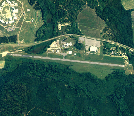 |
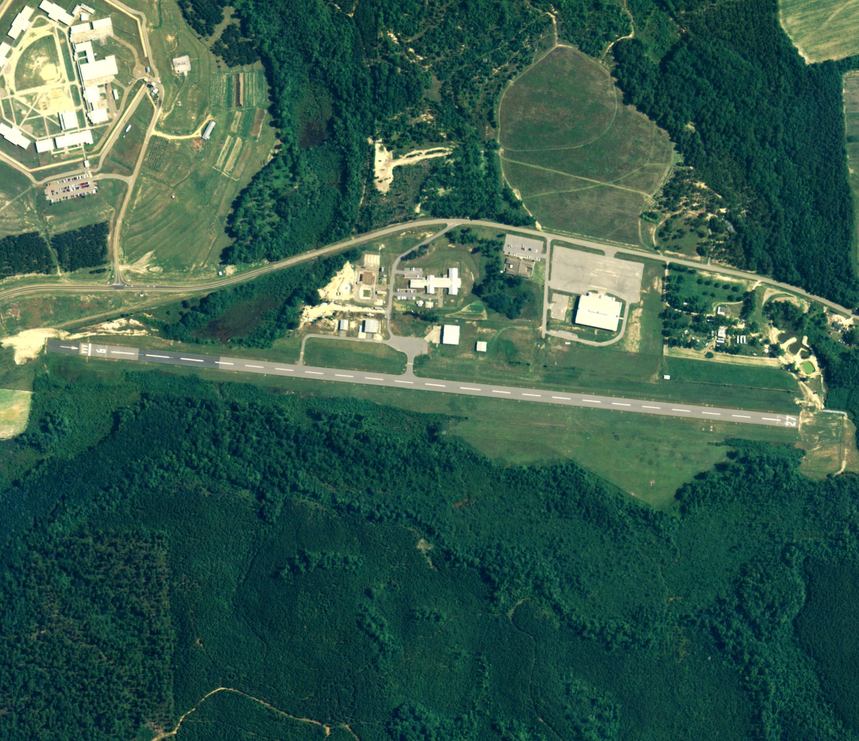
| NAIP aerial image, 30 June 2006 |
| IATA: none – ICAO: none – FAA LID: 11A |
| Summary |
| Airport type |
Public |
| Owner |
City of Clayton |
| Serves |
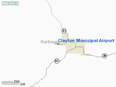
Clayton, Alabama |
| Elevation AMSL |
435 ft / 132.6 m |
| Coordinates |
31°53′00″N 085°29′07″W / 31.8833333°N 85.48528°W / 31.8833333; -85.48528 |
| Runways |
| Direction |
Length |
Surface |
| ft |
m |
| 9/27 |
5,010 |
1,527 |
Asphalt |
| Statistics (2006) |
| Aircraft operations |
1,560 |
| Source: Federal Aviation Administration |
Clayton Municipal Airport (FAA LID: 11A) is a city-owned public-use airport located 2 nautical miles (4 km) west of the central business district of Clayton, a city in Barbour County, Alabama, United States. According to the FAA's National Plan of Integrated Airport Systems for 2009–2013, it is categorized as a general aviation facility.
Facilities and aircraft
Clayton Municipal Airport covers an area of 56 acres (0.09 sq mi; 0.23 km) which contains one runway designated 9/27 that is 5,010 x 80 feet (1,527 x 24 meters) asphalt pavement. For the 12-month period ending January 10, 2006, the airport had 1,560 general aviation aircraft operations.
The above content comes from Wikipedia and is published under free licenses – click here to read more.
Location
& QuickFacts
|
FAA Information Effective: |
2005-10-27 |
|
Airport Identifier: |
11A |
|
Longitude/Latitude: |
085-29-05.6650W/31-52-59.8500N
-85.484907/31.883292 (Estimated) |
|
Elevation: |
435
ft / 132.59 m (Surveyed) |
|
Land: |
56
acres |
|
From nearest city: |
2
nautical miles W of Clayton, AL |
|
Location: |
Barbour
County, AL |
|
Magnetic Variation: |
01W
(1985) |
Owner
& Manager
|
Ownership: |
Publicly
owned |
|
Owner: |
City
Of Clayton |
|
Address: |
Po
Box 385
Clayton, AL 36016 |
|
Phone number: |
334-775-3542 |
|
Manager: |
City
Of Clayton |
|
Address: |
Box
385
Clayton, AL 36016 |
|
Phone number: |
334-775-3542 |
Airport
Operations and Facilities
|
Airport Use: |
Open
to public |
|
Wind indicator: |
No |
|
Segmented Circle: |
No |
|
Control Tower: |
No |
|
Attendance Schedule: |
UNATNDD |
|
Lighting Schedule: |
DUSK-DAWN |
|
Beacon Color: |
Clear-Green
(lighted land airport) |
|
Landing fee charge: |
No |
|
Sectional chart: |
New
Orleans |
|
Region: |
ASO
- Southern |
|
Boundary ARTCC: |
ZTL
- Atlanta |
|
Responsible ARTCC: |
ZJX
- Jacksonville |
|
Tie-in FSS: |
ANB
- Anniston |
|
FSS on Airport: |
No |
|
FSS Phone: |
256-832-2100 |
|
FSS Toll Free: |
1-800-WX-BRIEF |
|
NOTAMs Facility: |
ANB
(NOTAM-d service avaliable) |
|
Federal Agreements: |
N |
Airport
Communications
Airport
Services
|
Fuel available: |
A |
|
Bottled Oxygen: |
NONE |
|
Bulk Oxygen: |
NONE |
Runway
Information
Runway 09/27
|
Dimension: |
4810
x 80 ft / 1466.1 x 24.4 m |
|
Surface: |
ASPH,
Good Condition |
|
Edge Lights: |
Medium |
| |
Runway
09 |
Runway
27 |
|
Longitude: |
085-29-33.3700W |
085-28-37.9600W |
|
Latitude: |
31-53-02.6100N |
31-52-57.0900N |
|
Elevation: |
422.00
ft |
435.00
ft |
|
Alignment: |
97 |
127 |
|
Traffic Pattern: |
Left |
Left |
|
Markings: |
Basic,
Good Condition |
Basic,
Fair Condition |
|
Displaced threshold: |
700.00
ft |
80.00
ft |
|
Centerline Lights: |
No |
No |
|
Touchdown Lights: |
No |
No |
|
Obstruction: |
17
ft road, 200.0 ft from runway,
61 ft left of centerline
APCH RATIO 23:1 FM DSPLCD THLD.
+4 FT FENCE 170 FT PARALLEL TO
RY END. |
64
ft trees, 707.0 ft from runway,
196 ft right of centerline, 7:1
slope to clear |
|
Radio
Navigation Aids
|
ID |
Type |
Name |
Ch |
Freq |
Var |
Dist |
|
XNE |
NDB |
Spring
Hill |
|
281.00 |
00E |
27.7
nm |
|
TO |
NDB |
Blood |
|
365.00 |
01W |
31.8
nm |
|
HYE |
NDB |
Hanchey |
|
221.00 |
00E |
32.2
nm |
|
AWS |
NDB |
Lawson |
|
335.00 |
02W |
34.1
nm |
|
LOR |
NDB |
Lowe |
|
269.00 |
03W |
34.1
nm |
|
BVG |
NDB |
Boll
Weevil |
|
352.00 |
03E |
41.6
nm |
|
OZ |
NDB |
Ruckr |
|
212.00 |
00E |
43.0
nm |
|
XBR |
NDB |
Brantley |
|
410.00 |
00E |
45.6
nm |
|
HEY |
VOR |
Hanchey |
|
110.60 |
02E |
31.8
nm |
|
EDN |
VOR |
Enterprise |
|
116.60 |
03W |
41.3
nm |
|
LSF |
VOR/DME |
Lawson |
051X |
111.40 |
02W |
36.8
nm |
|
TGE |
VOR/DME |
Tuskegee |
120X |
117.30 |
02E |
37.3
nm |
|
OZR |
VOR/DME |
Cairns |
049X |
111.20 |
02E |
38.9
nm |
|
EUF |
VORTAC |
Eufaula |
029X |
109.20 |
02E |
18.5
nm |
|
RRS |
VORTAC |
Wiregrass |
053X |
111.60 |
02E |
36.1
nm |
|
MGM |
VORTAC |
Montgomery |
058X |
112.10 |
03E |
47.2
nm |
|
CSG |
VORTAC |
Columbus |
118X |
117.10 |
01E |
50.0
nm |
Remarks
Clayton Municipal Airport
Localion: Barbour
County, AL
Tel:
334-775-3542
Images and information placed above are from
http://www.airport-data.com/airport/11A/
We thank them for the data!
| General Info
|
| Country |
United States
|
| State |
ALABAMA
|
| FAA ID |
11A
|
| Latitude |
31-52-59.850N
|
| Longitude |
085-29-05.665W
|
| Elevation |
435 feet
|
| Near City |
CLAYTON
|
We don't guarantee the information is fresh and accurate. The data may be wrong or outdated.
For more up-to-date information please refer to other sources.
|
|