 |
|
| Centre Municipal Airport |
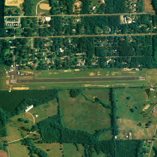 |
| NAIP aerial image, 15 June 2006 |
| IATA: none – ICAO: none – FAA LID: C22 |
| Summary |
| Airport type |
Public |
| Owner |
Centre, Alabama |
| Serves |
Centre, Alabama |
| Elevation AMSL |
619 ft / 188.7 m |
| Coordinates |
34°09′36″N 085°38′06″W / 34.16°N 85.635°W / 34.16; -85.635 |
| Runways |
| Direction |
Length |
Surface |
| ft |
m |
| 9/27 |
3,401 |
1,037 |
Asphalt |
| Statistics (2000) |
| Aircraft operations |
4,325 |
| Source: Federal Aviation Administration |
Centre Municipal Airport (FAA LID: C22) is a city-owned public-use airport located 3 nautical miles (6 km) east of the central business district of Centre, a city in Cherokee County, Alabama, United States. According to the FAA's National Plan of Integrated Airport Systems for 2009–2013, it is categorized as a general aviation facility.
Facilities and aircraft
Centre Municipal Airport covers an area of 43 acres (0.07 sq mi; 0.17 km) which contains one runway designated 9/27 is 3,401 x 80 feet (1,037 x 24 meters) asphalt pavement. For the 12-month period ending June 8, 2000, the airport had 4,325 general aviation/military aircraft operations.
The above content comes from Wikipedia and is published under free licenses – click here to read more.
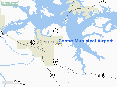
Location
& QuickFacts
|
FAA Information Effective: |
2005-10-27 |
|
Airport Identifier: |
C22 |
|
Longitude/Latitude: |
085-38-06.4660W/34-09-35.5450N
-85.635129/34.159874 (Estimated) |
|
Elevation: |
619
ft / 188.67 m (Surveyed) |
|
Land: |
43
acres |
|
From nearest city: |
3
nautical miles E of Centre, AL |
|
Location: |
Cherokee
County, AL |
|
Magnetic Variation: |
01W
(1985) |
Owner
& Manager
|
Ownership: |
Publicly
owned |
|
Owner: |
City
Of Centre |
|
Address: |
401
E. Main
Centre, AL 35960 |
|
Phone number: |
205-927-5222 |
|
Manager: |
City
Of Centre |
|
Address: |
401
E. Main Street
Centre, AL 35960 |
|
Phone number: |
205-927-5222 |
Airport
Operations and Facilities
|
Airport Use: |
Open
to public |
|
Wind indicator: |
Yes |
|
Segmented Circle: |
No |
|
Control Tower: |
No |
|
Attendance Schedule: |
UNATNDD
FOR ATTENDANT CALL (256) 927-5222. |
|
Lighting Schedule: |
DUSK-DAWN |
|
Beacon Color: |
Clear-Green
(lighted land airport) |
|
Landing fee charge: |
No |
|
Sectional chart: |
Atlanta |
|
Region: |
ASO
- Southern |
|
Boundary ARTCC: |
ZTL
- Atlanta |
|
Tie-in FSS: |
ANB
- Anniston |
|
FSS on Airport: |
No |
|
FSS Phone: |
256-832-2100 |
|
FSS Toll Free: |
1-800-WX-BRIEF |
|
NOTAMs Facility: |
ANB
(NOTAM-d service avaliable) |
|
Federal Agreements: |
N |
Airport
Communications
Airport
Services
|
Airframe Repair: |
NONE |
|
Power Plant Repair: |
NONE |
|
Bottled Oxygen: |
NONE |
|
Bulk Oxygen: |
NONE |
Runway
Information
Runway 09/27
|
Dimension: |
3401
x 80 ft / 1036.6 x 24.4 m |
|
Surface: |
ASPH,
Fair Condition |
|
Weight Limit: |
Single
wheel: 16000 lbs. |
|
Edge Lights: |
Low |
| |
Runway
09 |
Runway
27 |
|
Longitude: |
085-38-26.6880W |
085-37-46.2190W |
|
Latitude: |
34-09-35.3850N |
34-09-35.6890N |
|
Elevation: |
603.00
ft |
619.00
ft |
|
Alignment: |
89 |
127 |
|
Traffic Pattern: |
Left |
Left |
|
Markings: |
Non-precision
instrument, Good Condition
RY 09/27 NO CNTRLN MARKINGS. |
Non-precision
instrument, Good Condition |
|
Obstruction: |
52
ft trees, 1200.0 ft from runway, 19:1
slope to clear |
50
ft trees, 1200.0 ft from runway, 275
ft left of centerline, 20:1 slope to
clear |
|
Radio
Navigation Aids
|
ID |
Type |
Name |
Ch |
Freq |
Var |
Dist |
|
FTP |
NDB |
Fort
Payne |
|
426.00 |
01W |
21.8
nm |
|
OYD |
NDB |
Floyd |
|
388.00 |
02W |
24.9
nm |
|
ARF |
NDB |
Saratoga |
|
296.00 |
02W |
29.8
nm |
|
OUK |
NDB |
Calhoun |
|
323.00 |
02W |
38.1
nm |
|
EVZ |
NDB |
Cartersville |
|
308.00 |
02W |
39.4
nm |
|
GPQ |
NDB |
Carrollton |
|
278.00 |
02W |
43.7
nm |
|
PLR |
NDB |
Pell
City |
|
257.00 |
01E |
47.4
nm |
|
GAD |
VOR/DME |
Gadsden |
070X |
112.30 |
02E |
24.9
nm |
|
TDG |
VOR/DME |
Talladega |
025X |
108.80 |
02E |
40.6
nm |
|
RMG |
VORTAC |
Rome |
101X |
115.40 |
01E |
25.7
nm |
Centre Municipal Airport
Localion: Cherokee
County, AL
Tel:
205-927-5222
Images and information placed above are from
http://www.airport-data.com/airport/C22/
We thank them for the data!
| General Info
|
| Country |
United States
|
| State |
ALABAMA
|
| FAA ID |
C22
|
| Latitude |
34-09-35.545N
|
| Longitude |
085-38-06.466W
|
| Elevation |
619 feet
|
| Near City |
CENTRE
|
We don't guarantee the information is fresh and accurate. The data may be wrong or outdated.
For more up-to-date information please refer to other sources.
|
|


