 |
|
| Carl Folsom Airport |
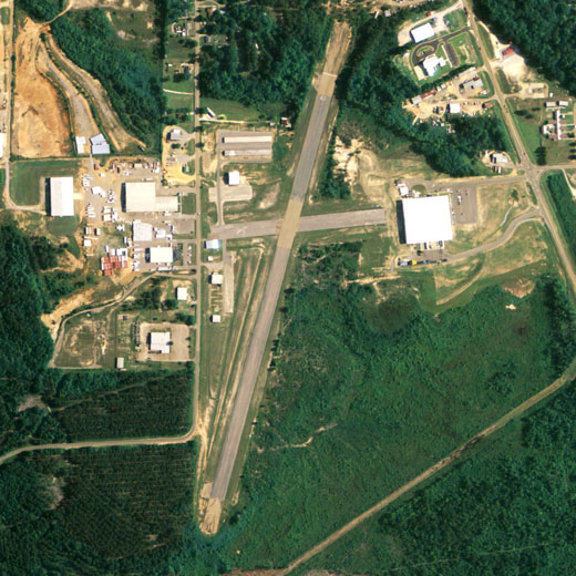 |
| NAIP aerial image, 30 June 2006 |
| IATA: none – ICAO: none – FAA LID: 14J |
| Summary |
| Airport type |
Public |
| Owner |
Elba Airport Authority |
| Serves |
Elba, Alabama |
| Elevation AMSL |
258 ft / 79 m |
| Coordinates |
31°24′36″N 086°05′25″W / 31.41°N 86.09028°W / 31.41; -86.09028 |
| Runways |
| Direction |
Length |
Surface |
| ft |
m |
| 1/19 |
3,056 |
931 |
Asphalt |
| Statistics (2006) |
| Aircraft operations |
5,360 |
| Source: Federal Aviation Administration |
Carl Folsom Airport (FAA LID: 14J) is a city-owned public-use airport located 2 nautical miles (4 km) west of the central business district of Elba, a city in Coffee County, Alabama, United States. According to the FAA's National Plan of Integrated Airport Systems for 2009–2013, it is categorized as a general aviation facility.
Facilities and aircraft
Carl Folsom Airport covers an area of 171 acres (0.27 sq mi; 0.69 km), and contains one runway designated 1/19 that is 3,056 x 100 feet (931 x 30 meters) with asphalt pavement. For the 12-month period ending June 19, 2006, the airport had 5,360 general aviation/military aircraft operations.
The above content comes from Wikipedia and is published under free licenses – click here to read more.
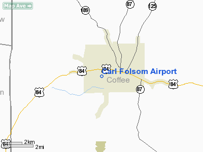
Location
& QuickFacts
|
FAA Information Effective: |
2005-10-27 |
| Airport Identifier: |
14J |
| Longitude/Latitude: |
086-05-25.2100W/31-24-36.1500N
-86.090336/31.410042 (Estimated) |
| Elevation: |
258
ft / 78.64 m (Estimated) |
| Land: |
171
acres |
| From nearest city: |
2
nautical miles W of Elba, AL |
| Location: |
Coffee
County, AL |
| Magnetic Variation: |
00W
(1985) |
Owner
& Manager
|
Ownership: |
Publicly
owned |
| Owner: |
Elba
Arpt Authority |
| Address: |
Po
Box 315
Elba, AL 36323 |
| Phone number: |
334-897-3088 |
| Manager: |
James
Pool |
| Address: |
Po
Box 315
Elba, AL 36323 |
| Phone number: |
334-897-2349 |
Airport
Operations and Facilities
|
Airport Use: |
Open
to public |
| Wind indicator: |
Yes |
| Segmented Circle: |
No |
| Control Tower: |
No |
| Attendance Schedule: |
ALL/MON-SAT/0900-1700 |
| Lighting Schedule: |
DUSK-DAWN |
| Beacon Color: |
Clear-Green
(lighted land airport) |
| Landing fee charge: |
No |
| Sectional chart: |
New
Orleans |
| Region: |
ASO
- Southern |
| Boundary ARTCC: |
ZJX
- Jacksonville |
| Tie-in FSS: |
ANB
- Anniston |
| FSS on Airport: |
No |
| FSS Phone: |
256-832-2100 |
| FSS Toll Free: |
1-800-WX-BRIEF |
| NOTAMs Facility: |
ANB
(NOTAM-d service avaliable) |
| Federal Agreements: |
N |
Airport
Communications
Airport
Services
|
Fuel available: |
100LL
CREDIT CARD FUEL DISPENSER. |
|
Airframe Repair: |
MAJOR |
| Bottled Oxygen: |
NONE |
| Bulk Oxygen: |
NONE |
Runway
Information
Runway 01/19
|
Dimension: |
3056
x 100 ft / 931.5 x 30.5 m
RY 01/19 HAS 350 FT BY 100 FT ASPH OVERRUN ON
NORTH END, 200 FT BY 100 FT ASPH OVERRUN ON SOUTH
END. |
| Surface: |
ASPH,
Poor Condition
GRASS GROWING THROUGH CRACKS IN RY. |
| Weight Limit: |
Single
wheel: 4000 lbs. |
| Edge Lights: |
Low
LTD THLD RY 19 DSPLCD 10 FT; 2990 FT AVBL FOR
NIGHT OPS. |
| |
Runway
01 |
Runway
19 |
|
Longitude: |
086-05-29.8900W |
086-05-20.5400W |
|
Latitude: |
31-24-21.5600N |
31-24-50.7300N |
|
Elevation: |
249.00
ft |
252.00
ft |
|
Traffic Pattern: |
Left |
Left |
|
Markings: |
Nonstandard,
Good Condition
NSTD MKGS; SOLID DOUBLE CNTRLN; RY 19 NUMBERS
DSPLCD 180 FT. |
Nonstandard,
Good Condition |
|
VASI: |
|
pulsating/steady
burning on left side |
|
Obstruction: |
51
ft trees, 986.0 ft from runway, 159 ft left
of centerline, 15:1 slope to clear |
40
ft trees, 598.0 ft from runway, 54 ft right
of centerline, 9:1 slope to clear |
|
Radio
Navigation Aids
| ID |
Type |
Name |
Ch |
Freq |
Var |
Dist |
| BVG |
NDB |
Boll
Weevil |
|
352.00 |
03E |
7.0
nm |
| XBR |
NDB |
Brantley |
|
410.00 |
00E |
13.8
nm |
| JUY |
NDB |
Judd |
|
264.00 |
02W |
16.7
nm |
| XNE |
NDB |
Spring
Hill |
|
281.00 |
00E |
17.5
nm |
| OZ |
NDB |
Ruckr |
|
212.00 |
00E |
17.9
nm |
| LOR |
NDB |
Lowe |
|
269.00 |
03W |
18.0
nm |
| HYE |
NDB |
Hanchey |
|
221.00 |
00E |
22.7
nm |
| TO |
NDB |
Blood |
|
365.00 |
01W |
25.3
nm |
| PRN |
NDB |
Persimmon/dcmsnd |
|
359.00 |
00E |
37.7
nm |
| BKK |
NDB |
Tri
County |
|
275.00 |
02W |
42.0
nm |
| EDN |
VOR |
Enterprise |
|
116.60 |
03W |
11.8
nm |
| UIA |
VOR |
Andalusia |
|
110.20 |
00E |
16.6
nm |
| HEY |
VOR |
Hanchey |
|
110.60 |
02E |
22.6
nm |
| FYL |
VOR |
Tri
County |
|
108.40 |
08W |
42.2
nm |
| OZR |
VOR/DME |
Cairns |
049X |
111.20 |
02E |
20.5
nm |
| RRS |
VORTAC |
Wiregrass |
053X |
111.60 |
02E |
34.7
nm |
| CEW |
VORTAC |
Crestview |
106X |
115.90 |
03E |
46.4
nm |
Carl Folsom Airport
Localion: Coffee
County, AL
Tel:
334-897-2349
Images and information placed above are from
http://www.airport-data.com/airport/61A/
We thank them for the data!
| General Info
|
| Country |
United States
|
| State |
ALABAMA
|
| FAA ID |
61A
|
| Latitude |
31-58-47.090N
|
| Longitude |
087-20-20.815W
|
| Elevation |
143 feet
|
| Near City |
CAMDEN
|
We don't guarantee the information is fresh and accurate. The data may be wrong or outdated.
For more up-to-date information please refer to other sources.
|
|


