|
|
Cairns Army Air Field (Fort Rucker) Airport |
Cairns Army Airfield (AAF)
Fort Rucker |
 |
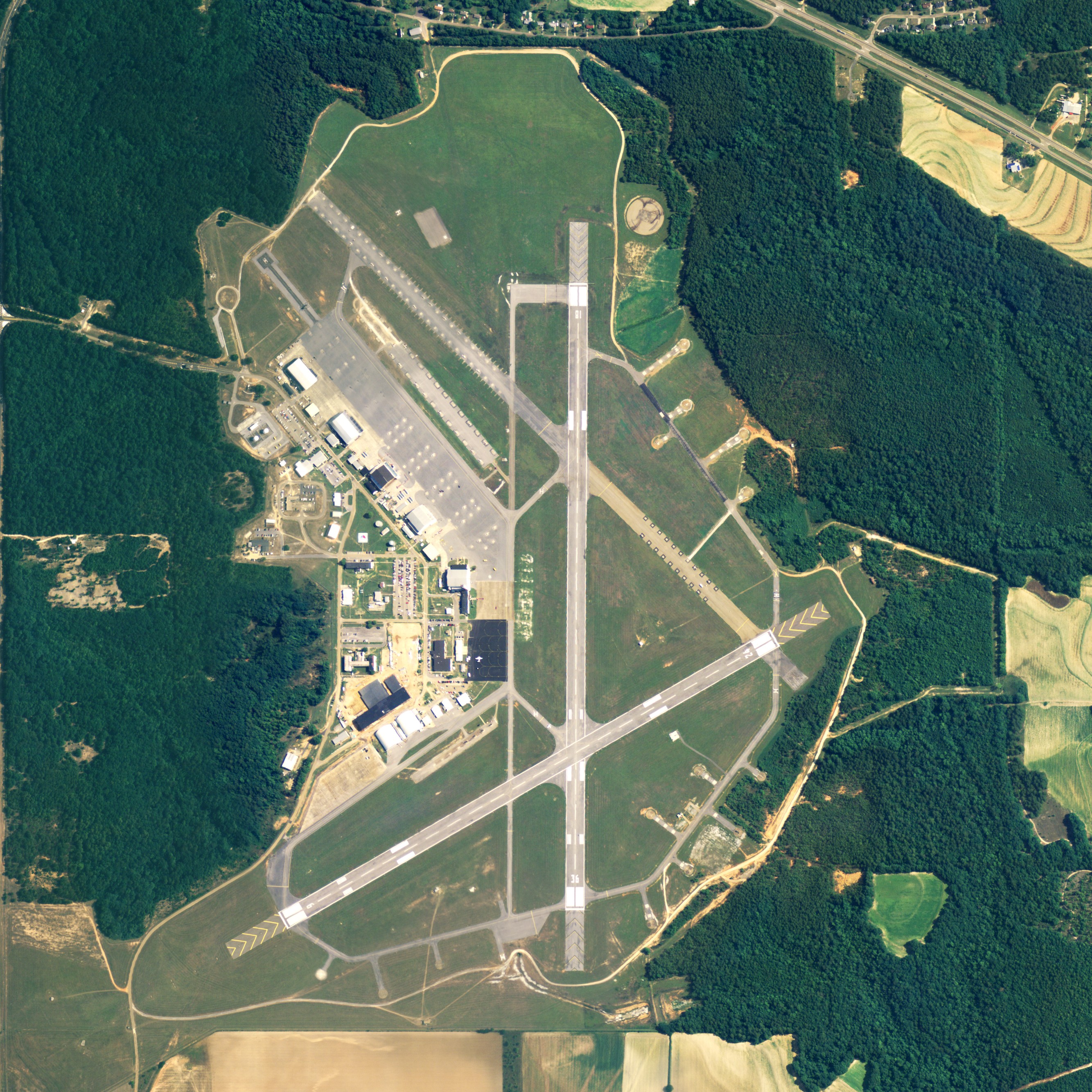
| NAIP aerial image, 30 June 2006 |
 |
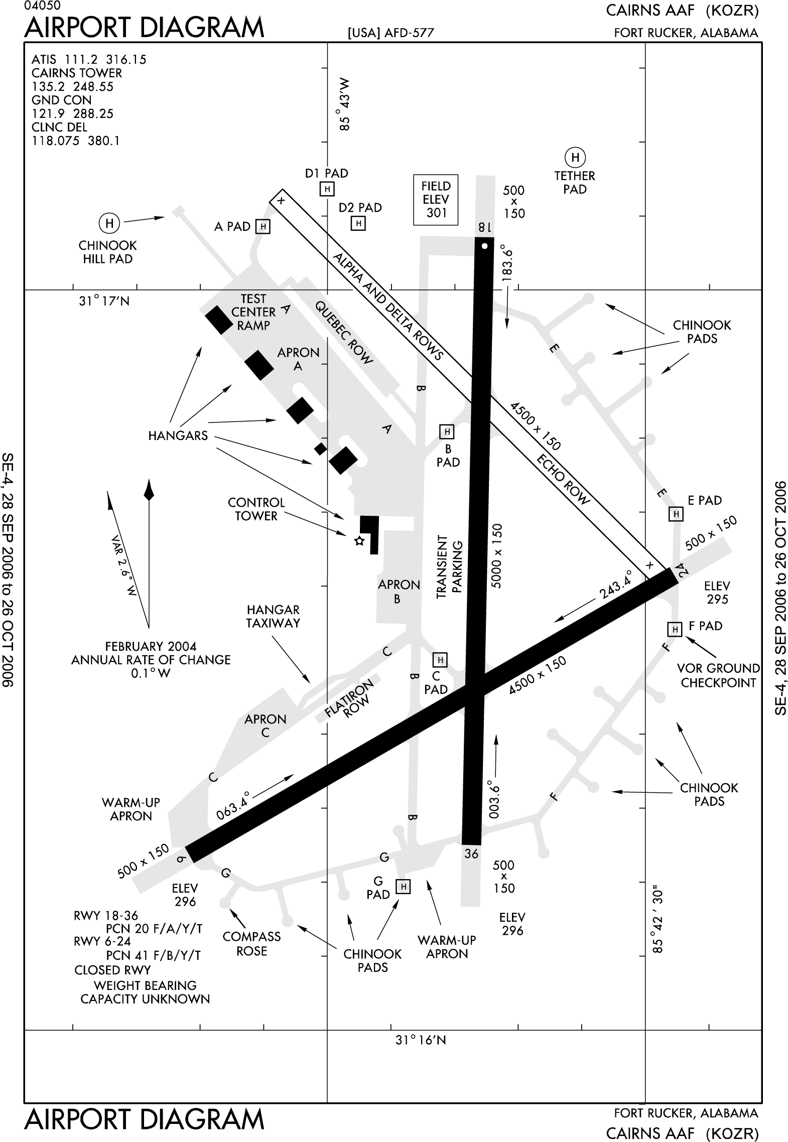
| FAA diagram of runway area |
| IATA: OZR – ICAO: KOZR – FAA LID: OZR |
| Summary |
| Airport type |
Military |
| Owner |
U.S. Army |
| Location |
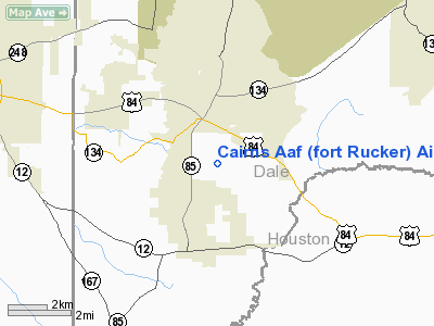
Fort Rucker / Dale County, Alabama |
| Elevation AMSL |
301 ft / 92 m |
| Coordinates |
31°16′33″N 085°42′48″W / 31.27583°N 85.71333°W / 31.27583; -85.71333 (Cairns Army Airfield) |
| Website |
www-rucker.army.mil |
| Runways |
| Direction |
Length |
Surface |
| ft |
m |
| 6/24 |
4,546 |
1,386 |
Asphalt |
| 18/36 |
5,025 |
1,532 |
Asphalt |
| Source: Federal Aviation Administration |
Cairns Army Airfield (IATA: OZR, ICAO: KOZR, FAA LID: OZR) is a military airport forming a part of Fort Rucker, in Dale County, Alabama, USA. It is owned by the United States Army. The airfield is south of the town of Daleville, which sits between it and the main post. History
In September 1942, 1,259 acres (5.1 km) south of Daleville were acquired for the construction of an airfield to support the training camp. It was a training airfield as part of the United States Army Air Forces Third Air Force during World War II, then placed on inactive status with the war's end. The field was acquired by Fort Rucker in 1952. It was known as Ozark Army Airfield until January 1959, when the name was changed to Cairns Army Airfield.
Current use
Fort Rucker is the Home of Army Aviation, where all of the Army's Aviators as well as many international and civilian personnel begin their rotary-wing flight training.
Cairns is one of the busiest airfields in the Army, training large numbers of Army aviators both day and night. It was named after Major General Bogardus S. Cairns, a World War II veteran and later commanding officer of Ft. Rucker who was killed in a helicopter crash nearby in 1958.
The Aviation Training Brigade consists of five battalions that conduct flight training at Fort Rucker at three training sites. 1st Battalion, 223d Aviation Regiment, Cairns Army Airfield and Knox Army Heliport conducts flight training in the CH-47, C-12 and conducts the Maintenance Test Pilot Courses, it also provides evaluations of flight training for contractors.
Facilities
Cairns AAF has two asphalt paved runways: 6/24 is 4,546 by 150 feet (1,386 x 46 m) and 18/36 is 5,025 by 150 feet (1,532 x 46 m).
In 1995 the pilots handled 209,000 aircraft movements without incident. In an average day tower operators handle 800 to 1,000 movements. What makes Cairns unique is the density in which it operates. The airfield may be launching 70 to 120 aircraft in the morning and afternoon, and then 50 or 60 at night for training.
The above content comes from Wikipedia and is published under free licenses – click here to read more.
Location
& QuickFacts
|
FAA Information Effective: |
2005-10-27 |
| Airport Identifier: |
OZR |
| Longitude/Latitude: |
085-42-48.0000W/31-16-32.4000N
-85.713333/31.275667 (Estimated) |
| Elevation: |
301
ft / 91.74 m (Estimated) |
| Land: |
0
acres |
| From nearest city: |
6
nautical miles S of Fort Rucker/ozark, AL |
| Location: |
Dale
County, AL |
| Magnetic Variation: |
00W
(1985) |
Owner
& Manager
|
Ownership: |
Army
owned |
| Owner: |
Us
Army Cairns Army Air Field |
| Address: |
9325
Gunston Road
Ft Belvoir, VA 22060 |
| Address: |
|
| Phone number: |
205-255-2314 |
Airport
Operations and Facilities
| Segmented Circle: |
No |
| Control Tower: |
Yes |
| Attendance Schedule: |
ALL/ALL/ALL |
| Lighting Schedule: |
DUSK-DAWN |
| Beacon Color: |
Split-Clear-Green
(lighted military airport) |
| Sectional chart: |
New
Orleans |
| Region: |
ASO
- Southern |
| Boundary ARTCC: |
ZJX
- Jacksonville |
| Tie-in FSS: |
OZR
- Cairns Baseops
FSS-ANNISTON ANB-NOTAM OZR |
| FSS on Airport: |
Yes |
| FSS Phone: |
205-255-2314 |
| NOTAMs Facility: |
OZR
(NOTAM-d service avaliable) |
Airport
Communications
Runway
Information
Runway
06/24
|
Dimension: |
4500
x 150 ft / 1371.6 x 45.7 m |
| Surface: |
ASPH,
|
| Edge Lights: |
High |
| |
Runway
06 |
Runway
24 |
|
Longitude: |
085-43-13.2360W |
085-42-26.6560W |
| Latitude: |
31-16-14.2480N |
31-16-36.6480N |
|
Elevation: |
297.00
ft |
294.00
ft |
| ILS Type: |
ILS |
|
|
Traffic Pattern: |
Left |
Left |
|
Runway
18/36
|
Dimension: |
5000
x 150 ft / 1524.0 x 45.7 m |
| Surface: |
ASPH,
|
| Edge Lights: |
Medium |
| |
Runway
18 |
Runway
36 |
|
Traffic Pattern: |
Left |
Left |
|
Radio
Navigation Aids
| ID |
Type |
Name |
Ch |
Freq |
Var |
Dist |
| LOR |
NDB |
Lowe |
|
269.00 |
03W |
5.3
nm |
| OZ |
NDB |
Ruckr |
|
212.00 |
00E |
6.1
nm |
| HYE |
NDB |
Hanchey |
|
221.00 |
00E |
6.4
nm |
| BVG |
NDB |
Boll
Weevil |
|
352.00 |
03E |
14.3
nm |
| BKK |
NDB |
Tri
County |
|
275.00 |
02W |
26.1
nm |
| XNE |
NDB |
Spring
Hill |
|
281.00 |
00E |
28.0
nm |
| XBR |
NDB |
Brantley |
|
410.00 |
00E |
34.4
nm |
| JUY |
NDB |
Judd |
|
264.00 |
02W |
34.8
nm |
| SMY |
NDB |
Soyya |
|
329.00 |
02W |
35.0
nm |
| TO |
NDB |
Blood |
|
365.00 |
01W |
38.9
nm |
| HEY |
VOR |
Hanchey |
|
110.60 |
02E |
6.7
nm |
| EDN |
VOR |
Enterprise |
|
116.60 |
03W |
9.8
nm |
| FYL |
VOR |
Tri
County |
|
108.40 |
08W |
26.6
nm |
| UIA |
VOR |
Andalusia |
|
110.20 |
00E |
34.9
nm |
| OZR |
VOR/DME |
Cairns |
049X |
111.20 |
02E |
0.8
nm |
| RRS |
VORTAC |
Wiregrass |
053X |
111.60 |
02E |
14.5
nm |
| MAI |
VORTAC |
Marianna |
087X |
114.00 |
00E |
42.3
nm |
Remarks
- OIL:
O-156
- CAUTION:
POSSIBLE HYDROPLANING DUE TO STANDING WATER ON INT OF
RWY 06-24 AND 18-36 FLW RAIN.
- CAUTION:
INTS STU TRNG.
- MISC:
ACFT INBD WITH CODES CTC BASE OPS 45 NM OUT. A TRAN ACFT
CREW MEMBER MUST REMAIN WITH ACFT DUR REFUL OPR.
- SEE
FLIP AP/1 FLT HAZ FOR FORT RUCKER AND SUPPLEMENTARY ARPT
RMK FOR CAIRNS AAF.
- MISC:
TRAN ALERT SVC AVBL 1200-0400Z++MON-FRI; 1400-2200Z++SUN.
- MISC:WX
OBS AVBL 24/7,INCL HOL. FCST AVBL 0600Z++ MON-0700Z++,
EXC HOL. WX OBSN VIS RSTD SW-NW. REMOTE BRIEFING SVC AVBL
28 OWS, SHAW AFB DSN 965-0939/43, C877-297-4129 (TOLL-FREE)
HTTPS://OWS.SHAW.AF.MIL
- RSTD:
ALL TRAN ACFT 1 HR PPR. ALL RON ACFT, AND ARR/DEP ACFT
WITH CODE ABOARD CTC BASE OPS DSN 558-8361/8433 C334-255-8361
1100-0700Z++ MON-FRI.
- RADAR:
SEE TERMINAL FLIP FOR RADAR MINIMA.
- JASU:
(MD-3)
- FUEL:
J8 AVCARD NOT ACCEPTED.
Cairns Army Air Field (Fort Rucker) Airport
Localion: Dale County,
AL
Tel:
205-255-2314
Images and information placed above are from
http://www.airport-data.com/airport/OZR/
We thank them for the data!
| General Info
|
| Country |
United States
|
| State |
ALABAMA
|
| FAA ID |
OZR
|
| Latitude |
31-16-36.621N
|
| Longitude |
085-42-35.764W
|
| Elevation |
298 feet
|
| Near City |
FORT RUCKER/OZARK
|
We don't guarantee the information is fresh and accurate. The data may be wrong or outdated.
For more up-to-date information please refer to other sources.
|
|