 |
|
Butler-choctaw County Airport |
| Butler-Choctaw County Airport |
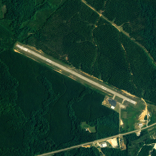 |
| NAIP aerial image, 23 June 2006 |
| IATA: none – ICAO: none – FAA LID: 09A |
| Summary |
| Airport type |
Public |
| Owner |
Choctaw County Airport Authority |
| Serves |
Butler, Alabama |
| Elevation AMSL |
134 ft / 40.8 m |
| Coordinates |
32°07′10″N 088°07′39″W / 32.11944°N 88.1275°W / 32.11944; -88.1275 |
| Runways |
| Direction |
Length |
Surface |
| ft |
m |
| 11/29 |
4,080 |
1,244 |
Asphalt |
| Statistics (2000) |
| Aircraft operations |
1,920 |
| Source: Federal Aviation Administration |
Butler-Choctaw County Airport (FAA LID: 09A) is a city-owned public-use airport located 5 nautical miles (9 km) northeast of the central business district of Butler, a city in Choctaw County, Alabama, United States. According to the FAA's National Plan of Integrated Airport Systems for 2009–2013, it is categorized as a general aviation facility.
Facilities and aircraft
Butler-Choctaw County Airport covers an area of 80 acres (0.12 sq mi; 0.32 km) which contains one runway designated 11/29 is 4,080 x 80 feet (1,244 x 24 meters) asphalt pavement. For the 12-month period ending March 27, 2000, the airport had 1,920 general aviation aircraft operations.
The above content comes from Wikipedia and is published under free licenses – click here to read more.
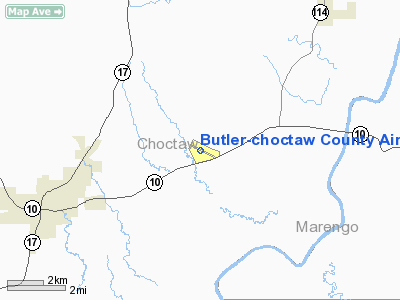
Location
& QuickFacts
|
FAA Information Effective: |
2005-10-27 |
| Airport Identifier: |
09A |
| Longitude/Latitude: |
088-07-38.8650W/32-07-09.5270N
-88.127462/32.119313 (Estimated) |
| Elevation: |
134
ft / 40.84 m (Surveyed) |
| Land: |
80
acres |
| From nearest city: |
5
nautical miles NE of Butler, AL |
| Location: |
Choctaw
County, AL |
| Magnetic Variation: |
01E
(1990) |
Owner
& Manager
|
Ownership: |
Publicly
owned |
| Owner: |
Choctaw
County Arpt Auth
FRANKLIN BONEY, CHRMN. |
| Address: |
602
Maureen Lane
Butler, AL 36904 |
| Phone number: |
205-459-3502 |
| Manager: |
Franklin
Boney |
| Address: |
602
Maureen Lane
Butler, AL 36904 |
| Phone number: |
205-459-3502 |
Airport
Operations and Facilities
|
Airport Use: |
Open
to public |
| Wind indicator: |
Yes
WIND INDICATOR OTS INDEFLY. |
| Segmented Circle: |
No |
| Control Tower: |
No |
| Attendance Schedule: |
UNATNDD |
| Lighting Schedule: |
DUSK-DAWN
ACTVT MIRL RY 11/29 - CTAF. |
| Beacon Color: |
Clear-Green
(lighted land airport) |
| Landing fee charge: |
No |
| Sectional chart: |
Memphis |
| Region: |
ASO
- Southern |
| Boundary ARTCC: |
ZTL
- Atlanta |
| Responsible ARTCC: |
ZME
- Memphis |
| Tie-in FSS: |
ANB
- Anniston |
| FSS on Airport: |
No |
| FSS Phone: |
256-832-2100 |
| FSS Toll Free: |
1-800-WX-BRIEF |
| NOTAMs Facility: |
ANB
(NOTAM-d service avaliable) |
| Federal Agreements: |
N |
Airport
Communications
|
CTAF: |
122.800 |
|
Unicom: |
122.800
|
Airport
Services
|
Airframe Repair: |
NONE |
|
Power Plant Repair: |
NONE |
| Bottled Oxygen: |
NONE |
| Bulk Oxygen: |
NONE |
Runway
Information
Runway
11/29
|
Dimension: |
4080
x 80 ft / 1243.6 x 24.4 m |
| Surface: |
ASPH,
Good Condition |
| Weight Limit: |
Single
wheel: 15000 lbs. |
| Edge Lights: |
Medium |
| |
Runway
11 |
Runway
29 |
| Longitude: |
088-08-00.2490W |
088-07-17.4900W |
| Latitude: |
32-07-18.2750N |
32-07-00.7910N |
| Elevation: |
116.00
ft |
134.00
ft |
| Alignment: |
116 |
127 |
| Traffic Pattern: |
Left |
Left |
| Markings: |
Non-precision
instrument, Good Condition |
Non-precision
instrument, Good Condition |
| Crossing Height: |
0.00
ft |
27.00
ft |
| VASI: |
|
2-box
on left side |
| Visual Glide Angle: |
0.00� |
3.00� |
| Obstruction: |
14
ft trees, 250.0 ft from runway, 70 ft left of
centerline, 3:1 slope to clear |
27
ft trees, 730.0 ft from runway, 10 ft left of
centerline, 19:1 slope to clear
RY 29 +5 FT BRUSH 100 FT FROM THLD & PERPENDICULAR
TO RY. |
|
Radio
Navigation Aids
| ID |
Type |
Name |
Ch |
Freq |
Var |
Dist |
| BCZ |
NDB |
Choctaw |
|
228.00 |
01E |
0.4
nm |
| RZO |
NDB |
Marengo |
|
391.00 |
01E |
18.6
nm |
| ME |
NDB |
Savoy |
|
356.00 |
01E |
33.7
nm |
| EOG |
NDB |
Greensboro |
|
417.00 |
01E |
37.4
nm |
| NMM |
TACAN |
Meridian |
056X |
|
01E |
34.8
nm |
| EWA |
VORTAC |
Kewanee |
085X |
113.80 |
04E |
22.5
nm |
| MEI |
VORTAC |
Meridian |
117X |
117.00 |
05E |
37.8
nm |
Remarks
Butler-choctaw County Airport
Localion: Choctaw
County, AL
Tel:
205-459-3502
Images and information placed above are from
http://www.airport-data.com/airport/09A/
We thank them for the data!
| General Info
|
| Country |
United States
|
| State |
ALABAMA
|
| FAA ID |
09A
|
| Latitude |
32-07-09.527N
|
| Longitude |
088-07-38.865W
|
| Elevation |
134 feet
|
| Near City |
BUTLER
|
We don't guarantee the information is fresh and accurate. The data may be wrong or outdated.
For more up-to-date information please refer to other sources.
|
|


