 |
|
Business Center Of Alabama Heliport |
|
|
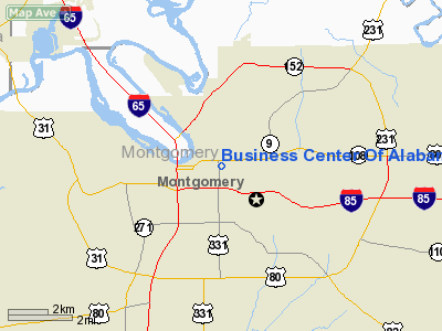
Location
& QuickFacts
| FAA Information Effective: |
2005-10-27 |
| Airport Identifier: |
1AL7 |
| Longitude/Latitude: |
086-17-54.0000W/32-22-39.0000N
-86.298333/32.377500 (Estimated) |
| Elevation: |
403
ft / 122.83 m (Estimated) |
| Land: |
0
acres |
| From nearest city: |
0
nautical miles SE of Montgomery, AL |
| Location: |
Montgomery
County, AL |
| Magnetic Variation: |
01W
(1990) |
Owner
& Manager
| Ownership: |
Privately
owned |
| Owner: |
Economic
Dev Partnership |
| Address: |
2
North Jackson Street
Montgomery, AL 36104-3809 |
| Phone number: |
334-223-5780 |
| Manager: |
Ann
Peagler |
| Address: |
2
North Jackson Street
Montgomery, AL 36104-3809 |
| Phone number: |
334-223-5780 |
Airport
Operations and Facilities
|
Airport Use: |
Private |
| Wind indicator: |
Yes |
| Segmented Circle: |
No |
| Control Tower: |
No |
| Attendance Schedule: |
UNATNDD |
| Lighting Schedule: |
RDO-CTL
ACTVT PERIMETER LGTS - 123.45. |
| Sectional chart: |
Atlanta |
| Region: |
ASO
- Southern |
| Boundary ARTCC: |
ZTL
- Atlanta |
| Tie-in FSS: |
ANB
- Anniston |
| FSS on Airport: |
No |
| FSS Phone: |
256-832-2100 |
| FSS Toll Free: |
1-800-WX-BRIEF |
Runway
Information
Helipad
H1
| Dimension: |
50
x 50 ft / 15.2 x 15.2 m |
| Surface: |
CONC,
|
| |
Runway
H1 |
Runway
|
| Traffic Pattern: |
Left |
Left |
|
Radio
Navigation Aids
| ID |
Type |
Name |
Ch |
Freq |
Var |
Dist |
| SE |
NDB |
Pollk |
|
344.00 |
01W |
32.6
nm |
| GGY |
NDB |
Gragg-wade |
|
338.00 |
01E |
32.7
nm |
| TO |
NDB |
Blood |
|
365.00 |
01W |
34.3
nm |
| DER |
NDB |
Alexander
City |
|
382.00 |
01W |
34.7
nm |
| PRN |
NDB |
Persimmon/dcmsnd |
|
359.00 |
00E |
35.5
nm |
| XNE |
NDB |
Spring
Hill |
|
281.00 |
00E |
44.8
nm |
| SCD |
NDB |
Sylacauga |
|
284.00 |
03W |
47.9
nm |
| XBR |
NDB |
Brantley |
|
410.00 |
00E |
49.0
nm |
| MXF |
TACAN |
Maxwell |
097X |
|
03E |
3.6
nm |
| TGE |
VOR/DME |
Tuskegee |
120X |
117.30 |
02E |
32.6
nm |
| JYU |
VOR/DME |
Junior |
083X |
113.60 |
01W |
35.2
nm |
| MGM |
VORTAC |
Montgomery |
058X |
112.10 |
03E |
9.4
nm |
Remarks
- PRVDD
PR USE; APCH/DEP RTE OPS FROM 350-010 DEG AND FROM 070-100
DEG; TKOF/LNDG AREA MKD; WIND INDICATOR IS MNTND.
Business Center Of Alabama Heliport
Localion: Montgomery
County, AL
Tel:
334-223-5780
Images and information placed above are from
http://www.airport-data.com/airport/1AL7/
We thank them for the data!
| General Info
|
| Country |
United States
|
| State |
ALABAMA
|
| FAA ID |
1AL7
|
| Latitude |
32-22-39.000N
|
| Longitude |
086-17-54.000W
|
| Elevation |
403 feet
|
| Near City |
MONTGOMERY
|
We don't guarantee the information is fresh and accurate. The data may be wrong or outdated.
For more up-to-date information please refer to other sources.
|
|


