|
 |
|
||||
|
|
|||||||||||||||||||||||||||||||||||||||||||||||||||||||||||||||||||||||||||||||||||||||||||||||||||||||||||||||||||||||||||||||||||||||||||||||||||||||||||||||||||||||||||||||||||||||||||||||||||||||||||||||||||||||||||||||||||||||||||||||||||||||||||||||||||||||||||||||||||||||||||||||||||||||||||||||||||||||||||||
| FAA Information Effective: |
2005-10-27 |
| Airport Identifier: |
06AL |
| Longitude/Latitude: |
085-58-20.7300W/31-23-18.3800N |
| Elevation: |
415 ft / 126.49 m (Estimated) |
| Land: |
0 acres |
| From nearest city: |
2 nautical miles W of Fort Rucker/new Brockton, AL |
| Location: |
Coffee County, AL |
| Magnetic Variation: |
02W (2000) |
| Ownership: |
Privately owned |
| Owner: |
Us Army Aviation Ctr & Fort Rucker |
| Address: |
Bldg
114 Novosel St |
| Phone number: |
334-255-9764 |
| Manager: |
Jack A Holmes |
| Address: |
Dptmsec
Airfield/airspace Branch, Bldg 114 Novosel St |
| Phone number: |
334-255-9764 |
Airport Operations and Facilities
|
| Dimension: |
1600 x 75 ft / 487.7 x 22.9 m |
||||||
| Surface: |
ASPH, |
||||||
|
|||||||
| Dimension: |
1600 x 75 ft / 487.7 x 22.9 m |
||||||
| Surface: |
ASPH, |
||||||
|
|||||||
| Dimension: |
1600 x 75 ft / 487.7 x 22.9 m |
||||||
| Surface: |
ASPH, |
||||||
|
|||||||
| Dimension: |
1600 x 75 ft / 487.7 x 22.9 m |
||||||
| Surface: |
ASPH, |
||||||
|
|||||||
| Dimension: |
1600 x 75 ft / 487.7 x 22.9 m |
||||||
| Surface: |
ASPH, |
||||||
|
|||||||
| Dimension: |
1600 x 75 ft / 487.7 x 22.9 m |
||||||
| Surface: |
ASPH, |
||||||
|
|||||||
| Dimension: |
1600 x 75 ft / 487.7 x 22.9 m |
||||||
| Surface: |
TURF, |
||||||
|
|||||||
| ID |
Type |
Name |
Ch |
Freq |
Var |
Dist |
| BVG |
NDB |
Boll Weevil |
352.00 |
03E |
3.2 nm |
|
| LOR |
NDB |
Lowe |
269.00 |
03W |
11.9 nm |
|
| OZ |
NDB |
Ruckr |
212.00 |
00E |
12.7 nm |
|
| HYE |
NDB |
Hanchey |
221.00 |
00E |
16.6 nm |
|
| XNE |
NDB |
Spring Hill |
281.00 |
00E |
17.8 nm |
|
| XBR |
NDB |
Brantley |
410.00 |
00E |
19.5 nm |
|
| JUY |
NDB |
Judd |
264.00 |
02W |
22.1 nm |
|
| TO |
NDB |
Blood |
365.00 |
01W |
27.4 nm |
|
| BKK |
NDB |
Tri County |
275.00 |
02W |
37.5 nm |
|
| PRN |
NDB |
Persimmon/dcmsnd |
359.00 |
00E |
43.0 nm |
|
| SMY |
NDB |
Soyya |
329.00 |
02W |
49.4 nm |
|
| EDN |
VOR |
Enterprise |
116.60 |
03W |
6.6 nm |
|
| HEY |
VOR |
Hanchey |
110.60 |
02E |
16.4 nm |
|
| UIA |
VOR |
Andalusia |
110.20 |
00E |
22.1 nm |
|
| FYL |
VOR |
Tri County |
108.40 |
08W |
37.8 nm |
|
| OZR |
VOR/DME |
Cairns |
049X |
111.20 |
02E |
14.5 nm |
| RRS |
VORTAC |
Wiregrass |
053X |
111.60 |
02E |
28.5 nm |
| CEW |
VORTAC |
Crestview |
106X |
115.90 |
03E |
49.6 nm |
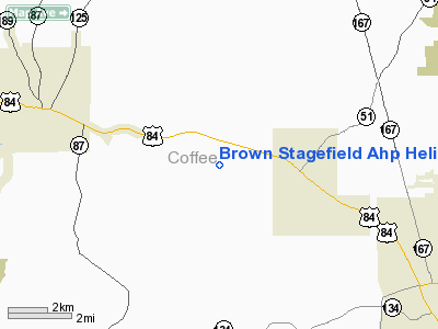
Brown Stagefield Ahp Heliport
Localion: Coffee County, AL
Tel: 334-255-9764
Images and information placed above are from
http://www.airport-data.com/airport/04AL/
We thank them for the data!
| General Info | |
|---|---|
| Country | United States |
| State | ALABAMA |
| FAA ID | 06AL |
| Latitude | 31-23-18.380N |
| Longitude | 085-58-20.730W |
| Elevation | 415 feet |
| Near City | FORT RUCKER/NEW BROCKTON |

 |
|
Copyright 2004-2026 © by Airports-Worldwide.com, Vyshenskoho st. 36, Lviv 79010, Ukraine Legal Disclaimer |