|
|
Brewton
Municipal Airport |
| Brewton Municipal Airport |
 |
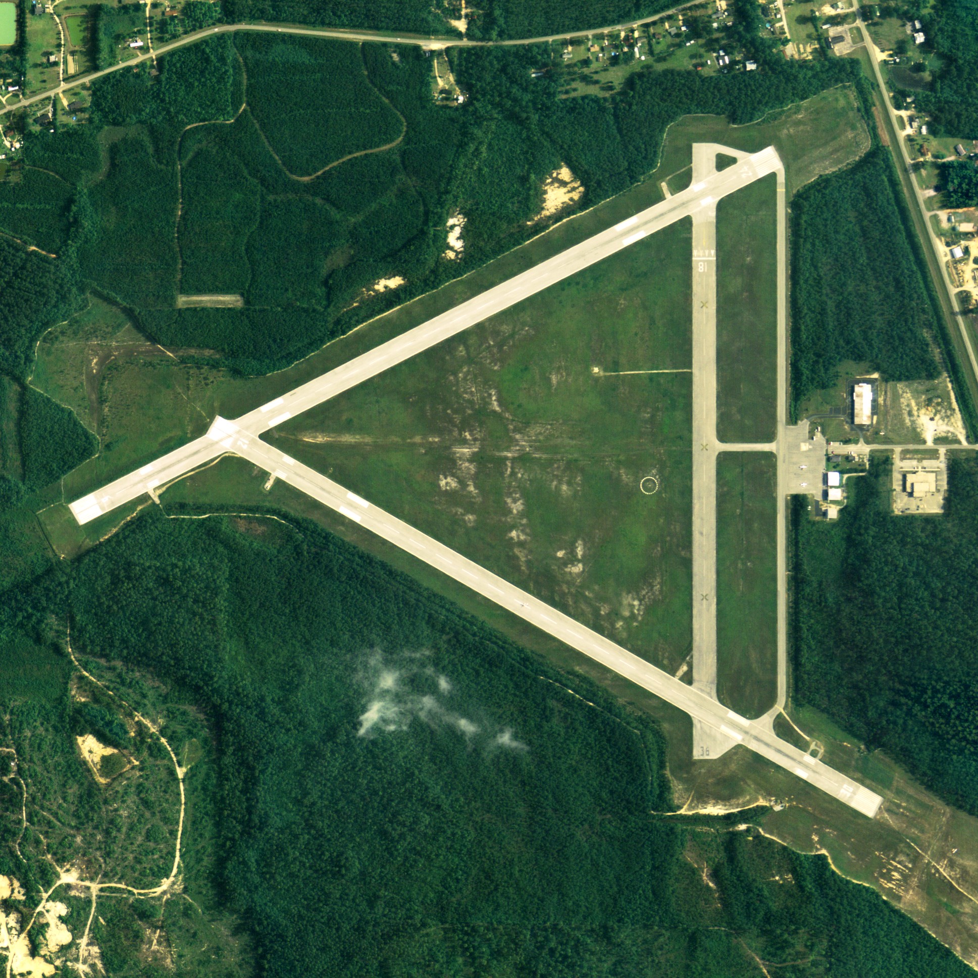
| NAIP aerial image, 30 June 2006 |
| IATA: none – ICAO: none – FAA LID: 12J |
| Summary |
| Airport type |
Public |
| Owner |
Brewton, Alabama |
| Serves |
Brewton, Alabama |
| Elevation AMSL |
99 ft / 30 m |
| Coordinates |
31°03′02″N 087°03′56″W / 31.05056°N 87.06556°W / 31.05056; -87.06556 |
| Runways |
| Direction |
Length |
Surface |
| ft |
m |
| 6/24 |
5,135 |
1,565 |
Asphalt |
| 12/30 |
5,066 |
1,544 |
Asphalt |
| 18/36 |
4,100 |
1,250 |
Asphalt |
| Statistics (2007) |
| Aircraft operations |
165,500 |
| Source: Federal Aviation Administration |
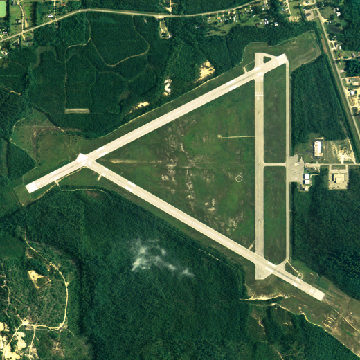
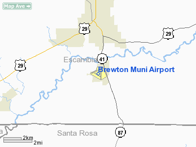
Brewton Municipal Airport (FAA LID: 12J) is a city-owned public-use airport located 3 nautical miles (6 km) south of the central business district of Brewton, a city in Escambia County, Alabama, United States. According to the FAA's National Plan of Integrated Airport Systems for 2009–2013, it is categorized as a general aviation facility.
Facilities and aircraft
Brewton Municipal Airport covers an area of 880 acres (1.37 sq mi; 3.56 km) which contains three asphalt paved runways: Runway 6/24 is 5,135 x 150 feet (1,565 x 46 meters); Runway 12/30 is 5,066 x 150 feet (1,544 x 46 meters) and Runway 18/36 is 4,100 x 150 feet (1,250 x 46 meters). For the 12-month period ending June 29, 2007 the airport had 165,500 general aviation/military aircraft operations.
The above content comes from Wikipedia and is published under free licenses – click here to read more.
Brewton Municipal Airport is situated 3 miles south of Brewton. Its runway
is 5,135 ft long.
Services:
- Airport management
- Aviation fuel
Aviation fuel services:
- Brand: Air BP
- Fueling hours: during regular FBO business hours; call FBO for hours
of operation
205 Airport Drive,
Brewton,
AL 36426-5019
Location
& QuickFacts
| FAA Information Effective: |
2005-10-27 |
| Airport Identifier: |
12J |
| Longitude/Latitude: |
087-03-56.2960W/31-03-02.1890N
-87.065638/31.050608 (Estimated) |
| Elevation: |
99
ft / 30.18 m (Estimated) |
| Land: |
880
acres |
| From nearest city: |
3
nautical miles S of Brewton, AL |
| Location: |
Escambia
County, AL |
| Magnetic Variation: |
01W
(2000) |
Owner
& Manager
| Ownership: |
Publicly
owned |
| Owner: |
City
Of Brewton |
| Address: |
Po
Box 368
Brewton, AL 36427 |
| Phone number: |
251-867-3281 |
| Manager: |
Earl
Lambert |
| Address: |
205
Airport Drive
Brewton, AL 36426 |
| Phone number: |
251-867-9997 |
Airport
Operations and Facilities
| Airport Use: |
Open
to public |
| Wind indicator: |
Yes |
| Segmented Circle: |
No |
| Control Tower: |
No |
| Attendance Schedule: |
ALL/MON-FRI/0800-1700,ALL/SAT/1430-1700
AFTER HRS CALL 334-867-2124. |
| Lighting Schedule: |
DUSK-DAWN
ACTVT MIRL RY 06/24, 12/30 & PAPI RY 12, 30 - CTAF |
| Beacon Color: |
Clear-Green
(lighted land airport) |
| Landing fee charge: |
No |
| Sectional chart: |
New
Orleans |
| Region: |
ASO
- Southern |
| Boundary ARTCC: |
ZJX
- Jacksonville |
| Tie-in FSS: |
ANB
- Anniston |
| FSS on Airport: |
No |
| FSS Phone: |
256-832-2100 |
| FSS Toll Free: |
1-800-WX-BRIEF |
| NOTAMs Facility: |
ANB
(NOTAM-d service avaliable) |
| Federal Agreements: |
NGY3 |
Airport
Communications
| CTAF: |
123.000 |
| Unicom: |
123.000
|
Airport
Services
| Fuel available: |
100LLA |
| Airframe Repair: |
MAJOR |
| Power Plant Repair: |
MAJOR |
| Bottled Oxygen: |
NONE |
| Bulk Oxygen: |
NONE |
Runway
Information
Runway 06/24
| Dimension: |
5135
x 150 ft / 1565.1 x 45.7 m |
| Surface: |
ASPH,
Good Condition |
| Weight Limit: |
Single
wheel: 40000 lbs.
Dual wheel: 60000 lbs. |
| Edge Lights: |
Medium |
| |
Runway
06 |
Runway
24 |
| Longitude: |
087-04-32.8200W |
087-03-40.2800W |
| Latitude: |
31-02-59.9400N |
31-03-23.0900N |
| Elevation: |
81.00
ft |
83.00
ft |
| Alignment: |
63 |
127 |
| Traffic Pattern: |
Left |
Left |
| Markings: |
Non-precision
instrument, Good Condition |
Non-precision
instrument, Good Condition |
| Obstruction: |
30
ft trees, 200.0 ft from runway, 250 ft right of centerline |
40
ft trees, 200.0 ft from runway, 245 ft right of centerline |
|
Runway 12/30
| Dimension: |
5066
x 150 ft / 1544.1 x 45.7 m |
| Surface: |
ASPH,
Good Condition |
| Weight Limit: |
Single
wheel: 40000 lbs.
Dual wheel: 60000 lbs. |
| Edge Lights: |
Medium |
| |
Runway
12 |
Runway
30 |
| Longitude: |
087-04-22.5700W |
087-03-32.5180W |
| Latitude: |
31-03-05.7300N |
31-02-40.1000N |
| Elevation: |
82.00
ft |
99.00
ft |
| Alignment: |
120 |
127 |
| Traffic Pattern: |
Left |
Left |
| Markings: |
Non-precision
instrument, Good Condition |
Non-precision
instrument, Good Condition |
| VASI: |
2-light
PAPI on left side |
2-light
PAPI on left side |
| Obstruction: |
30
ft trees, 1100.0 ft from runway, 30:1 slope to clear |
150
ft trees, 3020.0 ft from runway, 18:1 slope to clear |
|
Runway 18/36
| Dimension: |
4100
x 150 ft / 1249.7 x 45.7 m |
| Surface: |
ASPH,
Fair Condition |
| |
Runway
18 |
Runway
36 |
| Longitude: |
087-03-45.7820W |
087-03-45.7000W |
| Latitude: |
31-03-24.8580N |
31-02-44.2800N |
| Elevation: |
99.00
ft |
99.00
ft |
| Alignment: |
127 |
127 |
| Traffic Pattern: |
Left |
Left |
| Markings: |
Basic,
Poor Condition
RY 18/36 MARKINGS FADED. |
Nonstandard,
Poor Condition
NO NUMBERS; PARTIAL CNTRLN. |
| Displaced threshold: |
743.00
ft |
0.00
ft |
| Obstruction: |
20
ft trees, 212.0 ft from runway
RY 18 APCH RATIO 47:1 FROM DSPLCD THLD. |
20
ft trees, 480.0 ft from runway, 125 ft right of centerline,
14:1 slope to clear |
|
Radio
Navigation Aids
| ID |
Type |
Name |
Ch |
Freq |
Var |
Dist |
| PKZ |
NDB |
Pickens |
|
326.00 |
01E |
37.3
nm |
| JUY |
NDB |
Judd |
|
264.00 |
02W |
37.9
nm |
| ESU |
NDB |
Summerdale |
|
204.00 |
01E |
47.5
nm |
| DTS |
NDB |
Destin |
|
254.00 |
01W |
49.4
nm |
| NSE |
TACAN |
Whiting |
070X |
|
01E |
19.8
nm |
| NGS |
TACAN |
Santa
Rosa |
063X |
|
01E |
27.0
nm |
| HRT |
TACAN |
Hurlburt |
045X |
|
00E |
42.1
nm |
| NPA |
TACAN |
Pensacola |
119X |
|
01E |
43.6
nm |
| DWG |
TACAN |
Warrington |
002X |
|
00E |
44.4
nm |
| NUN |
VOR |
Saufley |
|
108.80 |
01E |
37.5
nm |
| UIA |
VOR |
Andalusia |
|
110.20 |
00E |
38.0
nm |
| CEW |
VORTAC |
Crestview |
106X |
115.90 |
03E |
24.1
nm |
| MVC |
VORTAC |
Monroeville |
115X |
116.80 |
04E |
28.7
nm |
Remarks
- MIL
TRAINING ACFT MONITOR UNICOM AND YIELD TO ALL CIVILIAN OPNS.
- RWY
06/24 & 12/30 DIST MARKERS EVERY 1000'; US NAVY EQUIP.
- PRIOR
TO FAA ACT
Brewton Municipal Airport
Escambia County, AL
Tel:
251-867-9997
Images and information placed above are from
http://www.airport-data.com/airport/12J/
http://www.cheapest-flights.gb.com/airports/us-airports/Alabama/Brewton-Municipal-Airport.shtml
We thank them for the data!
| General Info
|
| Country |
United States
|
| State |
ALABAMA
|
| FAA ID |
12J
|
| Latitude |
31-03-02.189N
|
| Longitude |
087-03-56.296W
|
| Elevation |
99 feet
|
| Near City |
BREWTON
|
We don't guarantee the information is fresh and accurate. The data may be wrong or outdated.
For more up-to-date information please refer to other sources.
|
|