 |
|
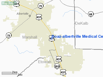
Boaz-albertville Medical Center Heliport |
Location
& QuickFacts
| FAA Information Effective: |
2005-10-27 |
| Airport Identifier: |
1AL0 |
| Longitude/Latitude: |
086-09-38.0000W/34-13-15.0000N
-86.160556/34.220833 (Estimated) |
| Elevation: |
1000
ft / 304.80 m (Estimated) |
| Land: |
0
acres |
| From nearest city: |
1
nautical miles N of Boaz, AL |
| Location: |
Marshall
County, AL |
| Magnetic Variation: |
01W
(1990) |
Owner
& Manager
| Ownership: |
Privately
owned |
| Owner: |
Boaz-albertville
Medical Ctr |
| Address: |
Hwy
431 S Po Drawer Z
Boaz, AL 35957 |
| Phone number: |
601-840-3550 |
| Manager: |
Milton
L. Craig |
| Address: |
Hwy
431 S Po Drawer Z
Boaz, AL 35957 |
| Phone number: |
601-840-3550 |
Airport
Operations and Facilities
| Airport Use: |
Private
MEDICAL USE. |
| Wind indicator: |
Yes |
| Segmented Circle: |
No |
| Control Tower: |
No |
| Attendance Schedule: |
UNATNDD |
| Lighting Schedule: |
PHONE
REQ
FOR PERIMETER LGTS CALL 601-840-3550. |
| Sectional chart: |
Atlanta |
| Region: |
ASO
- Southern |
| Boundary ARTCC: |
ZTL
- Atlanta |
| Tie-in FSS: |
ANB
- Anniston |
| FSS on Airport: |
No |
| FSS Phone: |
256-832-2100 |
| FSS Toll Free: |
1-800-WX-BRIEF |
Runway
Information
Helipad
H1
| Dimension: |
40
x 40 ft / 12.2 x 12.2 m |
| Surface: |
CONC,
|
| |
Runway
H1 |
Runway
|
| Traffic Pattern: |
Left |
Left |
|
Radio
Navigation Aids
| ID |
Type |
Name |
Ch |
Freq |
Var |
Dist |
| ARF |
NDB |
Saratoga |
|
296.00 |
02W |
3.7
nm |
| FTP |
NDB |
Fort
Payne |
|
426.00 |
01W |
30.2
nm |
| CPP |
NDB |
Cole
Spring |
|
230.00 |
01W |
34.1
nm |
| HUA |
NDB |
Redstone |
|
287.00 |
00W |
38.8
nm |
| PLR |
NDB |
Pell
City |
|
257.00 |
01E |
40.0
nm |
| CWH |
NDB |
Capshaw |
|
350.00 |
01W |
45.2
nm |
| OYD |
NDB |
Floyd |
|
388.00 |
02W |
49.7
nm |
| GAD |
VOR/DME |
Gadsden |
070X |
112.30 |
02E |
15.2
nm |
| TDG |
VOR/DME |
Talladega |
025X |
108.80 |
02E |
39.3
nm |
| DCU |
VOR/DME |
Decatur |
075X |
112.80 |
01W |
46.4
nm |
| RQZ |
VORTAC |
Rocket |
059X |
112.20 |
02E |
41.8
nm |
| VUZ |
VORTAC |
Vulcan |
091X |
114.40 |
02E |
49.5
nm |
| BHM |
VOT |
Birmingham
Muni |
|
110.00 |
|
49.4
nm |
Remarks
- PROVIDED
PR USE; APCH/DEP OPS TO/FM 270 DEG RADIAL; TKOF/LNDG AREA MKD; WIND
INDICATOR MNTND.
Boaz-albertville Medical Center Heliport
Marshall County, AL
Tel:
601-840-3550
Images and information placed above are from
http://www.airport-data.com/airport/1AL0/
We thank them for the data!
| General Info
|
| Country |
United States
|
| State |
ALABAMA
|
| FAA ID |
1AL0
|
| Latitude |
34-13-15.000N
|
| Longitude |
086-09-38.000W
|
| Elevation |
1000 feet
|
| Near City |
BOAZ
|
We don't guarantee the information is fresh and accurate. The data may be wrong or outdated.
For more up-to-date information please refer to other sources.
|
|


