 |
|
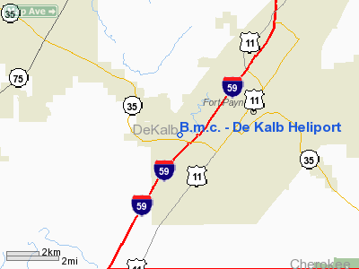
B.m.c. - De Kalb Heliport |
|
|
Location
& QuickFacts
| FAA Information Effective: |
2005-10-27 |
| Airport Identifier: |
0AL4 |
| Longitude/Latitude: |
085-45-23.0000W/34-26-27.0000N
-85.756389/34.440833 (Estimated) |
| Elevation: |
870
ft / 265.18 m (Estimated) |
| Land: |
0
acres |
| From nearest city: |
2
nautical miles SW of Fort Payne, AL |
| Location: |
De
Kalb County, AL |
| Magnetic Variation: |
01W
(1990) |
Owner
& Manager
| Ownership: |
Privately
owned |
| Owner: |
Baptist
Medical Ctr - De Kalb |
| Address: |
200
Medical Center Drive
Fort Payne, AL 35967 |
| Phone number: |
205-845-3150 |
| Manager: |
Don
E. O'diam |
| Address: |
B.m.c.-
De Kalb P.o. Box 778
Fort Payne, AL 35967 |
| Phone number: |
205-845-3150 |
Airport
Operations and Facilities
| Airport Use: |
Private
MEDICAL USE. |
| Segmented Circle: |
No |
| Control Tower: |
No |
| Attendance Schedule: |
UNATNDD |
| Lighting Schedule: |
PHONE
REQ
FOR PERIMETER LGTS CALL 205-845-3150. |
| Sectional chart: |
Atlanta |
| Region: |
ASO
- Southern |
| Boundary ARTCC: |
ZTL
- Atlanta |
| Tie-in FSS: |
ANB
- Anniston |
| FSS on Airport: |
No |
| FSS Phone: |
256-832-2100 |
| FSS Toll Free: |
1-800-WX-BRIEF |
Runway
Information
Helipad
H1
| Dimension: |
30
x 30 ft / 9.1 x 9.1 m |
| Surface: |
CONC,
|
| |
Runway
H1 |
Runway
|
| Traffic Pattern: |
Left |
Left |
|
Radio
Navigation Aids
| ID |
Type |
Name |
Ch |
Freq |
Var |
Dist |
| FTP |
NDB |
Fort
Payne |
|
426.00 |
01W |
6.3
nm |
| ARF |
NDB |
Saratoga |
|
296.00 |
02W |
25.8
nm |
| OYD |
NDB |
Floyd |
|
388.00 |
02W |
30.6
nm |
| APT |
NDB |
Jasper |
|
382.00 |
02W |
38.2
nm |
| OUK |
NDB |
Calhoun |
|
323.00 |
02W |
41.2
nm |
| UWI |
NDB |
Whitfield |
|
400.00 |
03W |
45.2
nm |
| UOS |
NDB |
Sewanee |
|
275.00 |
02E |
46.4
nm |
| BGF |
NDB |
Boiling
Fork |
|
263.00 |
02W |
46.9
nm |
| EVZ |
NDB |
Cartersville |
|
308.00 |
02W |
47.6
nm |
| HUA |
NDB |
Redstone |
|
287.00 |
00W |
48.6
nm |
| GAD |
VOR/DME |
Gadsden |
070X |
112.30 |
02E |
32.3
nm |
| RMG |
VORTAC |
Rome |
101X |
115.40 |
01E |
35.8
nm |
| GQO |
VORTAC |
Choo
Choo |
105X |
115.80 |
01E |
43.2
nm |
| RQZ |
VORTAC |
Rocket |
059X |
112.20 |
02E |
48.4
nm |
Remarks
- PRVDD
PR USE; APCH/DEP RTE OPS FROM 060-080 DEGS & FROM 240-260 DEGS;
TKOF/LNDG AREA MKD; WIND INDICATOR MNTND.
B.m.c. - De Kalb Heliport
De Kalb County, AL
Tel:
205-845-3150
Images and information placed above are from
http://www.airport-data.com/airport/0AL4/
We thank them for the data!
| General Info
|
| Country |
United States
|
| State |
ALABAMA
|
| FAA ID |
0AL4
|
| Latitude |
34-26-27.000N
|
| Longitude |
085-45-23.000W
|
| Elevation |
870 feet
|
| Near City |
FORT PAYNE
|
We don't guarantee the information is fresh and accurate. The data may be wrong or outdated.
For more up-to-date information please refer to other sources.
|
|


