|
|
| Blackwell Field |
 |
| IATA: none – ICAO: none – FAA LID: 71J |
| Summary |
| Airport type |
Public |
| Owner |
Ozark, Alabama |
| Serves |
Ozark, Alabama |
| Elevation AMSL |
356 ft / 108.5 m |
| Coordinates |
31°25′55″N 085°37′14″W / 31.43194°N 85.62056°W / 31.43194; -85.62056 |
| Runways |
| Direction |
Length |
Surface |
| ft |
m |
| 12/30 |
5,153 |
1,571 |
Asphalt |
| Statistics (2007) |
| Aircraft operations |
91,500 |
| Source: Federal Aviation Administration |
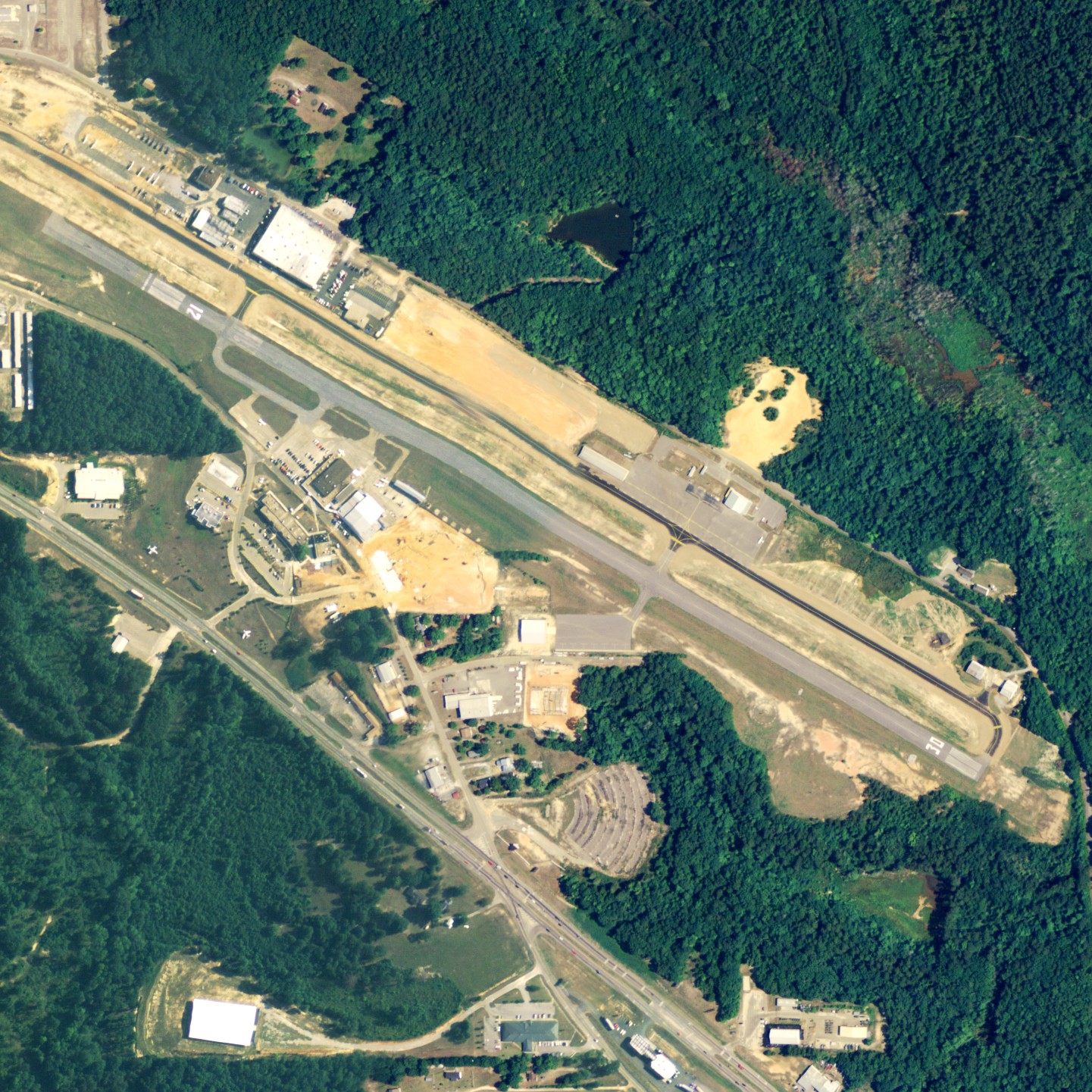
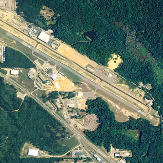
Blackwell Field (FAA LID: 71J) is a city-owned public-use airport located 2 nautical miles (4 km) southeast of the central business district of Ozark, a city in Dale County, Alabama, United States.
Facilities and aircraft
Blackwell Field covers an area of 114 acres (0.18 sq mi; 0.46 km), and contains one runway designated 12/30 that is 5,153 x 80 feet (1,571 x 24 meters) with asphalt pavement. For the 12-month period ending January 10, 2007, the airport had 91,500 general aviation aircraft operations.
The above content comes from Wikipedia and is published under free licenses – click here to read more.
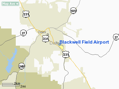
Location
& QuickFacts
| FAA Information Effective: |
2005-10-27 |
| Airport Identifier: |
71J |
| Longitude/Latitude: |
085-37-09.2000W/31-25-52.1000N
-85.619222/31.431139 (Estimated) |
| Elevation: |
356
ft / 108.51 m (Surveyed) |
| Land: |
114
acres |
| From nearest city: |
2
nautical miles SE of Ozark, AL |
| Location: |
Dale
County, AL |
| Magnetic Variation: |
01W
(1985) |
Owner
& Manager
| Ownership: |
Publicly
owned |
| Owner: |
Town
Of Ozark |
| Address: |
P.o.
Box 1987
Ozark, AL 36361 |
| Phone number: |
334-774-5393 |
| Manager: |
Roger
Buis |
| Address: |
American
Aviation Academy, 700 Valentine St
Ozark, AL 36360 |
| Phone number: |
334-774-3454 |
Airport
Operations and Facilities
| Airport Use: |
Open
to public |
| Wind indicator: |
Yes |
| Segmented Circle: |
Yes |
| Control Tower: |
No |
| Attendance Schedule: |
ALL/ALL/0700-1800 |
| Lighting Schedule: |
DUSK-DAWN
MIRL RY 12/30 PRESET MED INTST ONLY 1800-0700. ACTVT VASI RY 30
- CTAF. |
| Beacon Color: |
Clear-Green
(lighted land airport) |
| Landing fee charge: |
No |
| Sectional chart: |
New
Orleans |
| Region: |
ASO
- Southern |
| Boundary ARTCC: |
ZJX
- Jacksonville |
| Tie-in FSS: |
ANB
- Anniston |
| FSS on Airport: |
No |
| FSS Phone: |
256-832-2100 |
| FSS Toll Free: |
1-800-WX-BRIEF |
| NOTAMs Facility: |
ANB
(NOTAM-d service avaliable) |
| Federal Agreements: |
NGY |
Airport
Communications
| CTAF: |
122.700 |
| Unicom: |
122.700
|
Airport
Services
| Fuel available: |
100LLA |
| Airframe Repair: |
MAJOR |
| Power Plant Repair: |
MAJOR |
| Bottled Oxygen: |
NONE |
| Bulk Oxygen: |
NONE |
Runway
Information
Runway
12/30
| Dimension: |
4200
x 80 ft / 1280.2 x 24.4 m |
| Surface: |
ASPH,
Good Condition |
| Weight Limit: |
Single
wheel: 25000 lbs. |
| Edge Lights: |
Medium |
| |
Runway
12 |
Runway
30 |
| Longitude: |
085-37-29.9680W |
085-36-48.4930W |
| Latitude: |
31-26-02.8700N |
31-25-41.3140N |
| Elevation: |
356.00
ft |
344.00
ft |
| Alignment: |
121 |
127 |
| Traffic Pattern: |
Left |
Left |
| Markings: |
Non-precision
instrument, Good Condition |
Non-precision
instrument, Good Condition |
| Crossing Height: |
0.00
ft |
31.00
ft |
| VASI: |
|
4-box
on left side |
| Visual Glide Angle: |
0.00� |
3.00� |
| Runway End Identifier: |
Yes |
|
| Obstruction: |
79
ft trees, 1705.0 ft from runway, 15 ft left of centerline,
19:1 slope to clear |
68
ft trees, 1990.0 ft from runway, 120 ft right of centerline,
26:1 slope to clear |
|
Radio
Navigation Aids
| ID |
Type |
Name |
Ch |
Freq |
Var |
Dist |
| HYE |
NDB |
Hanchey |
|
221.00 |
00E |
4.2
nm |
| LOR |
NDB |
Lowe |
|
269.00 |
03W |
7.7
nm |
| OZ |
NDB |
Ruckr |
|
212.00 |
00E |
16.0
nm |
| BVG |
NDB |
Boll
Weevil |
|
352.00 |
03E |
19.5
nm |
| XNE |
NDB |
Spring
Hill |
|
281.00 |
00E |
23.7
nm |
| TO |
NDB |
Blood |
|
365.00 |
01W |
34.6
nm |
| BKK |
NDB |
Tri
County |
|
275.00 |
02W |
34.8
nm |
| XBR |
NDB |
Brantley |
|
410.00 |
00E |
35.4
nm |
| SMY |
NDB |
Soyya |
|
329.00 |
02W |
39.3
nm |
| JUY |
NDB |
Judd |
|
264.00 |
02W |
40.3
nm |
| HEY |
VOR |
Hanchey |
|
110.60 |
02E |
3.8
nm |
| EDN |
VOR |
Enterprise |
|
116.60 |
03W |
16.7
nm |
| FYL |
VOR |
Tri
County |
|
108.40 |
08W |
35.4
nm |
| UIA |
VOR |
Andalusia |
|
110.20 |
00E |
40.3
nm |
| OZR |
VOR/DME |
Cairns |
049X |
111.20 |
02E |
11.2
nm |
| RRS |
VORTAC |
Wiregrass |
053X |
111.60 |
02E |
13.1
nm |
| EUF |
VORTAC |
Eufaula |
029X |
109.20 |
02E |
40.0
nm |
| MAI |
VORTAC |
Marianna |
087X |
114.00 |
00E |
46.4
nm |
Remarks
- < TRAFFIC IN OPERATE HELICOPTERS FLYING>
- RY
& PARALLEL TWYS CNTRLN SEPARATION IS 150 FT.
- 500'
STOPWAY AT STOP END OF RWY 30. MARKED AND LIGHTED AS TAXIWAY.
- PILOTS
DEPARTING BLACKWELL VFR TO THE EAST OR NORTH REMAIN AT 1500 FT MSL
OR BLO TIL APRXLY 5 MI FM THE ARPT TO AVOID CONFLICT WITH TFC ON IFR
APCH TO THE DOTHAN ARPT.
Blackwell Field Airport
Dale County, AL
Tel:
334-774-3454
Images and information placed above are from
http://www.airport-data.com/airport/71J/
We thank them for the data!
| General Info
|
| Country |
United States
|
| State |
ALABAMA
|
| FAA ID |
71J
|
| Latitude |
31-25-52.100N
|
| Longitude |
085-37-09.200W
|
| Elevation |
356 feet
|
| Near City |
OZARK
|
We don't guarantee the information is fresh and accurate. The data may be wrong or outdated.
For more up-to-date information please refer to other sources.
|
|