 |
|
| Bibb County Airport |
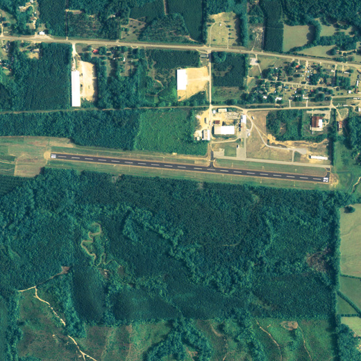 |
| NAIP aerial image, 29 June 2006 |
| IATA: none – ICAO: none – FAA LID: 0A8 |
| Summary |
| Airport type |
Public |
| Owner |
Bibb County |
| Serves |
Bibb County, Alabama |
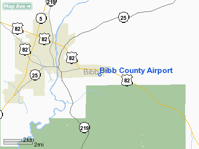
| Location |
Brent, Alabama |
| Elevation AMSL |
251 ft / 76.5 m |
| Coordinates |
32°56′13″N 087°05′26″W / 32.93694°N 87.09056°W / 32.93694; -87.09056 |
| Runways |
| Direction |
Length |
Surface |
| ft |
m |
| 10/28 |
4,200 |
1,280 |
Asphalt |
| Statistics (2006) |
| Aircraft operations |
3,542 |
| Source: Federal Aviation Administration |
Bibb County Airport (FAA LID: 0A8) is a county-owned public-use airport in Bibb County, Alabama, United States. It is located 3 nautical miles (6 km) east of the central business district of Brent, Alabama. According to the FAA's National Plan of Integrated Airport Systems for 2009–2013, it is categorized as a general aviation facility.
Facilities and aircraft
Bibb County Airport covers an area of 56 acres (0.09 sq mi; 0.23 km) which contains one runway designated 10/28 is 4,200 x 80 feet (1,280 x 24 meters) asphalt pavement. For the 12-month period ending May 30, 2006, the airport had 3,542 general aviation/military aircraft operations.
The above content comes from Wikipedia and is published under free licenses – click here to read more.
Location
& QuickFacts
| FAA Information Effective: |
2005-10-27 |
| Airport Identifier: |
0A8 |
| Longitude/Latitude: |
087-05-19.9790W/32-56-12.4460N
-87.088883/32.936791 (Estimated) |
| Elevation: |
251
ft / 76.50 m (Surveyed) |
| Land: |
56
acres |
| From nearest city: |
3
nautical miles E of Centreville, AL |
| Location: |
Bibb
County, AL |
| Magnetic Variation: |
00E
(1985) |
Owner
& Manager
| Ownership: |
Publicly
owned |
| Owner: |
Bibb
County |
| Address: |
103
Davidson Ave
Centreville, AL 35042 |
| Phone number: |
205-926-9717 |
| Manager: |
Don
Lee |
| Address: |
P.o.
Box 416
Centreville, AL 35042 |
| Phone number: |
205-926-5186
ALSO 205-926-4493. |
Airport
Operations and Facilities
| Airport Use: |
Open
to public |
| Wind indicator: |
Yes |
| Segmented Circle: |
No |
| Control Tower: |
No |
| Attendance Schedule: |
ALL/ALL/DAWN-DUSK
FOR SERVICE AFT HRS CALL 205-926-9076. |
| Lighting Schedule: |
DUSK-DAWN |
| Beacon Color: |
Clear-Green
(lighted land airport) |
| Landing fee charge: |
No |
| Sectional chart: |
Atlanta |
| Region: |
ASO
- Southern |
| Boundary ARTCC: |
ZTL
- Atlanta |
| Tie-in FSS: |
ANB
- Anniston |
| FSS on Airport: |
No |
| FSS Phone: |
256-832-2100 |
| FSS Toll Free: |
1-800-WX-BRIEF |
| NOTAMs Facility: |
ANB
(NOTAM-d service avaliable) |
| Federal Agreements: |
N |
Airport
Communications
| CTAF: |
122.800 |
| Unicom: |
122.800
|
Airport
Services
| Fuel available: |
100LLMOGAS |
| Airframe Repair: |
MAJOR |
| Power Plant Repair: |
MAJOR |
| Bottled Oxygen: |
NONE |
| Bulk Oxygen: |
NONE |
Runway
Information
Runway 10/28
| Dimension: |
4200
x 80 ft / 1280.2 x 24.4 m |
| Surface: |
ASPH,
Fair Condition |
| Weight Limit: |
Single
wheel: 18000 lbs. |
| Edge Lights: |
Medium
4110 FT OF RY AVBL FOR NIGHT OPNS. |
| |
Runway
10 |
Runway
28 |
| Traffic Pattern: |
Left |
Left |
| Displaced threshold: |
90.00
ft |
0.00
ft |
| VASI: |
pulsating/steady
burning on right side |
pulsating/steady
burning on right side |
| Obstruction: |
87
ft trees, 1080.0 ft from runway, 215 ft left of centerline,
10:1 slope to clear
OBSTN CLNC SLOPE 15:1 FROM DSPLCD THLD.
+3-+6 FT BRUSH 90 FT FM & PERPENDICULAR TO RY END. |
39
ft tree, 1400.0 ft from runway, 230 ft left of centerline,
30:1 slope to clear
+4 FT FENCE 70 FT FM RY END; +5 FT BERM PERPENDICULAR TO
EXTDD CNTRLN 150 FT FM RY END. |
|
Radio
Navigation Aids
| ID |
Type |
Name |
Ch |
Freq |
Var |
Dist |
| BEQ |
NDB |
Bessemer |
|
368.00 |
00E |
24.0
nm |
| GGY |
NDB |
Gragg-wade |
|
338.00 |
01E |
24.6
nm |
| EOG |
NDB |
Greensboro |
|
417.00 |
01E |
35.3
nm |
| BH |
NDB |
Mcden |
|
224.00 |
01W |
36.6
nm |
| SE |
NDB |
Pollk |
|
344.00 |
01W |
40.9
nm |
| SCD |
NDB |
Sylacauga |
|
284.00 |
03W |
41.4
nm |
| MXF |
TACAN |
Maxwell |
097X |
|
03E |
49.5
nm |
| JYU |
VOR/DME |
Junior |
083X |
113.60 |
01W |
35.9
nm |
| OKW |
VORTAC |
Brookwood |
047X |
111.00 |
00E |
19.9
nm |
| LDK |
VORTAC |
Crimson |
125X |
117.80 |
03E |
29.7
nm |
| VUZ |
VORTAC |
Vulcan |
091X |
114.40 |
02E |
45.1
nm |
| BHM |
VOT |
Birmingham
Muni |
|
110.00 |
|
41.2
nm |
Remarks
- FBO
- BIBB AVIATION.
- BEFORE
FAA ACT.
Bibb County Airport
Bibb County, AL
Tel:
205-926-5186
Images and information placed above are from
http://www.airport-data.com/airport/0A8/
We thank them for the data!
| General Info
|
| Country |
United States
|
| State |
ALABAMA
|
| FAA ID |
0A8
|
| Latitude |
32-56-12.446N
|
| Longitude |
087-05-19.979W
|
| Elevation |
251 feet
|
| Near City |
CENTREVILLE
|
We don't guarantee the information is fresh and accurate. The data may be wrong or outdated.
For more up-to-date information please refer to other sources.
|
|


