 |
|
| Bessemer Airport |
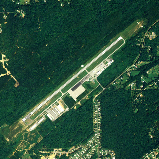 |
| NAIP aerial image, 2006 |
| IATA: none – ICAO: KEKY – FAA LID: EKY |
| Summary |
| Airport type |
Public |
| Owner |
City of Bessemer |
| Serves |
Bessemer, Alabama |
| Elevation AMSL |
700 ft / 213 m |
| Coordinates |
33°18′45″N 086°55′35″W / 33.3125°N 86.92639°W / 33.3125; -86.92639 |
| Runways |
| Direction |
Length |
Surface |
| ft |
m |
| 5/23 |
6,007 |
1,831 |
Asphalt |
| Statistics (2010) |
| Aircraft operations |
102,600 |
| Based aircraft |
99 |
| Source: Federal Aviation Administration |
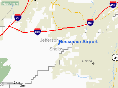
Bessemer Airport (ICAO: KEKY, FAA LID: EKY, formerly 2A3) is a city-owned public-use airport located three nautical miles (6 km) southeast of the central business district of Bessemer, a city in Jefferson County, Alabama, United States. According to the FAA's National Plan of Integrated Airport Systems for 2009–2013, it is categorized as a reliever airport for the Birmingham-Shuttlesworth International Airport.
Although many U.S. airports use the same three-letter location identifier for the FAA and IATA, this facility is assigned EKY by the FAA but has no designation from the IATA.
Facilities and Aircraft
Bessemer Airport covers an area of 380 acres (154 ha) at an elevation of 700 feet (213 m) above mean sea level. It has one runway designated 5/23 with an asphalt surface measuring 6,007 by 100 feet (1,831 x 30 m). An Instrument Landing System was installed in 2000. The airport received funding to expand the runway from 5,700 feet (1,737 m). Bessemer Airport also has a facility for aircraft restoration and maintenance run by Premier Aviation. A Civil Air Patrol squadron also operates from this airport.
For the 12-month period ending January 27, 2010, the airport had 102,600 general aviation aircraft operations, an average of 281 per day. At that time there were 99 aircraft based at this airport: 70% single-engine, 20% multi-engine, 7% jet and 3% helicopter.
The above content comes from Wikipedia and is published under free licenses – click here to read more.
Location
& QuickFacts
| FAA Information Effective: |
2005-10-27 |
| Airport Identifier: |
EKY |
| Longitude/Latitude: |
086-55-33.3080W/33-18-46.3840N
-86.925919/33.312884 (Estimated) |
| Elevation: |
699
ft / 213.06 m (Surveyed) |
| Land: |
380
acres |
| From nearest city: |
3
nautical miles SE of Bessemer, AL |
| Location: |
Jefferson
County, AL |
| Magnetic Variation: |
00E
(1990) |
Owner
& Manager
| Ownership: |
Publicly
owned |
| Owner: |
City
Of Bessemer |
| Address: |
1800
N Third Ave
Bessemer, AL 35020 |
| Phone number: |
205-424-4060 |
| Manager: |
Tommy
Morrow |
| Address: |
900
Mitchell Field Rd
Bessemer, AL 35022 |
| Phone number: |
205-425-9500 |
Airport
Operations and Facilities
| Airport Use: |
Open
to public |
| Wind indicator: |
Yes |
| Segmented Circle: |
Yes |
| Control Tower: |
No |
| Attendance Schedule: |
ALL/ALL/0730-2000 |
| Lighting Schedule: |
DUSK-DAWN
ACTVT MIRL RY 05/23 - CTAF. |
| Beacon Color: |
Clear-Green
(lighted land airport) |
| Landing fee charge: |
No |
| Sectional chart: |
Atlanta |
| Region: |
ASO
- Southern |
| Boundary ARTCC: |
ZTL
- Atlanta |
| Tie-in FSS: |
ANB
- Anniston |
| FSS on Airport: |
No |
| FSS Phone: |
256-832-2100 |
| FSS Toll Free: |
1-800-WX-BRIEF |
| NOTAMs Facility: |
ANB
(NOTAM-d service avaliable) |
| Federal Agreements: |
NGY |
Airport
Communications
| CTAF: |
123.000 |
| Unicom: |
123.000
|
Airport
Services
| Fuel available: |
100LLA
FOR FUEL AFTER HRS CALL 205-425-9500. |
| Airframe Repair: |
MAJOR |
| Power Plant Repair: |
MAJOR |
| Bottled Oxygen: |
NONE |
| Bulk Oxygen: |
NONE |
Runway
Information
Runway
05/23
| Dimension: |
5700
x 100 ft / 1737.4 x 30.5 m |
| Surface: |
ASPH,
Good Condition |
| Weight Limit: |
Single
wheel: 60000 lbs.
Dual wheel: 60000 lbs. |
| Edge Lights: |
Medium |
| |
Runway
05 |
Runway
23 |
| Longitude: |
086-55-58.9620W |
086-55-07.6520W |
| Latitude: |
33-18-28.1870N |
33-19-04.5790N |
| Elevation: |
699.00
ft |
700.00
ft |
| Alignment: |
50 |
127 |
| ILS Type: |
ILS/DME |
|
| Traffic Pattern: |
Left |
Left |
| Markings: |
Non-precision
instrument, Poor Condition
/23 MARKINGS FADED. |
Non-precision
instrument, Poor Condition |
| VASI: |
2-box
on left side |
2-box
on left side |
| Runway End Identifier: |
Yes |
Yes |
| Obstruction: |
,
50:1 slope to clear |
33
ft trees, 1250.0 ft from runway, 31:1 slope to clear |
|
Radio
Navigation Aids
| ID |
Type |
Name |
Ch |
Freq |
Var |
Dist |
| BEQ |
NDB |
Bessemer |
|
368.00 |
00E |
0.1
nm |
| BH |
NDB |
Mcden |
|
224.00 |
01W |
12.6
nm |
| SCD |
NDB |
Sylacauga |
|
284.00 |
03W |
31.7
nm |
| GGY |
NDB |
Gragg-wade |
|
338.00 |
01E |
31.9
nm |
| PLR |
NDB |
Pell
City |
|
257.00 |
01E |
37.0
nm |
| TDG |
VOR/DME |
Talladega |
025X |
108.80 |
02E |
47.0
nm |
| OKW |
VORTAC |
Brookwood |
047X |
111.00 |
00E |
16.9
nm |
| VUZ |
VORTAC |
Vulcan |
091X |
114.40 |
02E |
21.5
nm |
| LDK |
VORTAC |
Crimson |
125X |
117.80 |
03E |
30.9
nm |
| BHM |
VOT |
Birmingham
Muni |
|
110.00 |
|
17.3
nm |
Bessemer Airport
Jefferson County, AL
Tel:
205-425-9500
Images and information placed above are from
http://www.airport-data.com/airport/EKY/
We thank them for the data!
| General Info
|
| Country |
United States
|
| State |
ALABAMA
|
| FAA ID |
EKY
|
| Latitude |
33-18-46.384N
|
| Longitude |
086-55-33.308W
|
| Elevation |
700 feet
|
| Near City |
BESSEMER
|
We don't guarantee the information is fresh and accurate. The data may be wrong or outdated.
For more up-to-date information please refer to other sources.
|
|


