 |
|
| Atmore Municipal Airport |
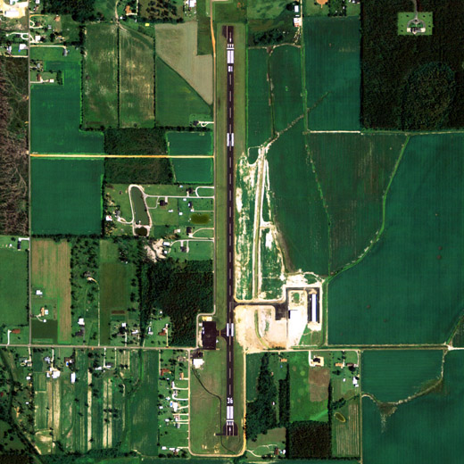 |
| NAIP aerial image, 30 June 2006 |
| IATA: none – ICAO: none – FAA LID: 0R1 |
| Summary |
| Airport type |
Public |
| Owner |
Atmore, Alabama |
| Serves |
Atmore, Alabama |
| Elevation AMSL |
287 ft / 88 m |
| Coordinates |
31°00′58″N 087°26′48″W / 31.01611°N 87.44667°W / 31.01611; -87.44667 |
| Runways |
| Direction |
Length |
Surface |
| ft |
m |
| 18/36 |
4,952 |
1,509 |
Asphalt |
| Statistics (2007) |
| Aircraft operations |
3,870 |
| Source: Federal Aviation Administration |
Atmore Municipal Airport (FAA LID: 0R1) is a city-owned public-use airport located 3 nautical miles (6 km) east of the central business district of Atmore, a city in Escambia County, Alabama, United States. According to the FAA's National Plan of Integrated Airport Systems for 2009–2013, it is categorized as a general aviation facility.
Facilities and aircraft
Atmore Municipal Airport covers an area of 43 acres (0.07 sq mi; 0.17 km) which contains one runway designated 18/36 is 4,952 x 80 feet (1,509 x 24 meters) asphalt pavement. For the 12-month period ending February 26, 2007, the airport had 3,870 general aviation aircraft operations.
The above content comes from Wikipedia and is published under free licenses – click here to read more.
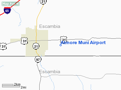
Location
& QuickFacts
| FAA Information Effective: |
2005-10-27 |
| Airport Identifier: |
0R1 |
| Longitude/Latitude: |
087-26-48.3350W/31-00-58.3750N
-87.446760/31.016215 (Estimated) |
| Elevation: |
287
ft / 87.48 m (Surveyed) |
| Land: |
43
acres |
| From nearest city: |
3
nautical miles E of Atmore, AL |
| Location: |
Escambia
County, AL |
| Magnetic Variation: |
01E
(1985) |
Owner
& Manager
| Ownership: |
Publicly
owned |
| Owner: |
Town
Of Atmore |
| Address: |
Po
Drawer 1297
Atmore, AL 36504 |
| Phone number: |
334-368-2253 |
| Manager: |
R.
E. Godwin |
| Address: |
15
Beacon Rd
Atmore, AL 36502 |
| Phone number: |
334-368-8171
ALSO 334-368-8033 OR 850-327-6430. |
Airport
Operations and Facilities
| Airport Use: |
Open
to public |
| Wind indicator: |
Yes |
| Segmented Circle: |
No |
| Control Tower: |
No |
| Attendance Schedule: |
ALL/MON-SAT/DAWN-DUSK |
| Lighting Schedule: |
DUSK-DAWN
ACTVT MIRL RY 18/36 AND PAPI RYS 18 & 36 - CTAF. |
| Beacon Color: |
Clear-Green
(lighted land airport)
ROTG BCN OTS INDEFLY. |
| Landing fee charge: |
No |
| Sectional chart: |
New
Orleans |
| Region: |
ASO
- Southern |
| Boundary ARTCC: |
ZJX
- Jacksonville |
| Tie-in FSS: |
ANB
- Anniston |
| FSS on Airport: |
No |
| FSS Phone: |
256-832-2100 |
| FSS Toll Free: |
1-800-WX-BRIEF |
| NOTAMs Facility: |
ANB
(NOTAM-d service avaliable) |
| Federal Agreements: |
N |
Airport
Communications
| CTAF: |
122.800 |
| Unicom: |
122.800
|
Airport
Services
| Fuel available: |
100LL |
| Bottled Oxygen: |
NONE |
| Bulk Oxygen: |
NONE |
Runway
Information
Runway 18/36
| Dimension: |
4952
x 80 ft / 1509.4 x 24.4 m |
| Surface: |
ASPH,
Good Condition |
| Weight Limit: |
Single
wheel: 16000 lbs. |
| Edge Lights: |
Non-standard
lighting system
NSTD MIRL; NO RY END LGTS; RY 36 FIRST 178 FT UNLIGHTED. |
| |
Runway
18 |
Runway
36 |
| Longitude: |
087-26-48.3900W |
087-26-48.2800W |
| Latitude: |
31-01-22.8800N |
31-00-33.8700N |
| Elevation: |
282.00
ft |
276.00
ft |
| Alignment: |
127 |
127 |
| Traffic Pattern: |
Left |
Left |
| Markings: |
Basic,
Poor Condition
RY 18/36 MARKINGS FADED. |
Nonstandard,
Poor Condition
NSTD DSPLCD THLD MARKINGS 1 FT WIDE WHITE BAR ONLY. |
| Displaced threshold: |
0.00
ft |
176.00
ft |
| VASI: |
2-light
PAPI on left side |
2-light
PAPI on left side |
| Obstruction: |
25
ft tree, 285.0 ft from runway, 110 ft right of centerline,
3:1 slope to clear
5 FT BERM 50 FT FM THLD; +20 FT BRUSH 50 FT FROM THLD 100
FT L. |
15
ft road, 250.0 ft from runway, 3:1 slope to clear
RY 36 APCH RATIO 28:1 TO DSPLCD THLD.
+15 FT ROAD AT THR 200 FT R. |
|
Radio
Navigation Aids
| ID |
Type |
Name |
Ch |
Freq |
Var |
Dist |
| ESU |
NDB |
Summerdale |
|
204.00 |
01E |
34.2
nm |
| PKZ |
NDB |
Pickens |
|
326.00 |
01E |
37.5
nm |
| MO |
NDB |
Wisle |
|
248.00 |
02E |
46.8
nm |
| NSE |
TACAN |
Whiting |
070X |
|
01E |
28.2
nm |
| NGS |
TACAN |
Santa
Rosa |
063X |
|
01E |
35.7
nm |
| NPA |
TACAN |
Pensacola |
119X |
|
01E |
40.1
nm |
| NUN |
VOR |
Saufley |
|
108.80 |
01E |
33.2
nm |
| MVC |
VORTAC |
Monroeville |
115X |
116.80 |
04E |
27.1
nm |
| BFM |
VORTAC |
Brookley |
075X |
112.80 |
04E |
39.7
nm |
| CEW |
VORTAC |
Crestview |
106X |
115.90 |
03E |
41.2
nm |
Remarks
Atmore Municipal Airport Escambia County, AL
Tel:
334-368-8171
Images and information placed above are from
http://www.airport-data.com/airport/0R1/
We thank them for the data!
| General Info
|
| Country |
United States
|
| State |
ALABAMA
|
| FAA ID |
0R1
|
| Latitude |
31-00-58.375N
|
| Longitude |
087-26-48.335W
|
| Elevation |
287 feet
|
| Near City |
ATMORE
|
We don't guarantee the information is fresh and accurate. The data may be wrong or outdated.
For more up-to-date information please refer to other sources.
|
|


