|
|
| Ardmore Airport |
 |
| IATA: none – ICAO: none – FAA LID: 1M3 |
| Summary |
| Airport type |
Private |
| Owner |
Richard C. Trulson |
| Serves |
Ardmore, Alabama |
| Elevation AMSL |
920 ft / 280 m |
| Coordinates |
34°58′40″N 086°53′05″W / 34.97778°N 86.88472°W / 34.97778; -86.88472 |
| Runways |
| Direction |
Length |
Surface |
| ft |
m |
| 1/19 |
2,700 |
823 |
Turf |
| Statistics (1996) |
| Aircraft operations |
2,260 |
| Source: Federal Aviation Administration |
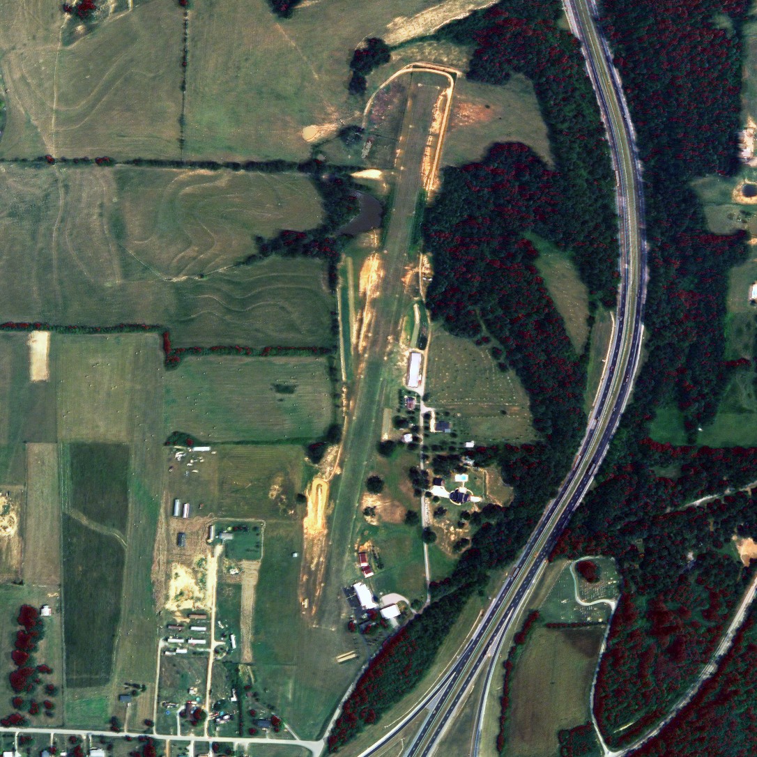
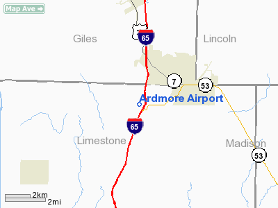
Ardmore Airport (FAA LID: 1M3) is a privately-owned airport located 2 miles (3.2 km) southwest of the central business district of Ardmore, a city in Limestone County, Alabama, United States.
Facilities and aircraft
Ardmore Airport covers an area of 46 acres (0.072 sq mi; 0.186 km), and contains one runway designated 1/19 that is 2,700 x 100 feet (823 x 30 meters) with a turf surface. For the 12-month period ending April 2, 1996, the airport had 2,260 general aviation/military aircraft operations.
The above content comes from Wikipedia and is published under free licenses – click here to read more.
Location
& QuickFacts
|
FAA Information Effective: |
2005-10-27 |
| Airport Identifier: |
1M3 |
| Longitude/Latitude: |
086-53-05.0140W/34-58-40.3050N
-86.884726/34.977863 (Estimated) |
| Elevation: |
920
ft / 280.42 m (Estimated) |
| Land: |
46
acres |
| From nearest city: |
2
nautical miles SW of Ardmore, AL |
| Location: |
Limestone
County, AL |
| Magnetic Variation: |
00W
(1985) |
Owner
& Manager
|
Ownership: |
Privately
owned |
| Owner: |
Richard
C. Trulson |
| Address: |
28825
Airport Lane
Ardmore, AL 35739 |
| Phone number: |
205-423-2736 |
| Manager: |
Richard
C Trulson/ardmore Avn |
| Address: |
28825
Arpt Lane
Ardmore, AL 35739 |
| Phone number: |
205-423-2736 |
Airport
Operations and Facilities
|
Airport Use: |
Private |
| Wind indicator: |
Yes |
| Segmented Circle: |
No |
| Control Tower: |
No |
| Attendance Schedule: |
ALL/MON-FRI/DALGT |
| Landing fee charge: |
No |
| Sectional chart: |
Atlanta |
| Region: |
ASO
- Southern |
| Boundary ARTCC: |
ZME
- Memphis |
| Tie-in FSS: |
ANB
- Anniston |
| FSS on Airport: |
No |
| FSS Phone: |
256-832-2100 |
| FSS Toll Free: |
1-800-WX-BRIEF |
| NOTAMs Facility: |
ANB
(NOTAM-d service avaliable) |
Airport
Communications
Airport
Services
|
Airframe Repair: |
MAJOR |
|
Power Plant Repair: |
MAJOR |
Runway
Information
Runway 01/19
|
Dimension: |
2700
x 100 ft / 823.0 x 30.5 m |
| Surface: |
TURF,
Fair Condition |
| |
Runway
01 |
Runway
19 |
| Traffic Pattern: |
Left |
Left |
| Obstruction: |
44
ft tree, 486.0 ft from runway, 124 ft left of
centerline, 11:1 slope to clear |
20
ft tree, 228.0 ft from runway, 148 ft left of
centerline, 11:1 slope to clear |
|
Radio
Navigation Aids
| ID |
Type |
Name |
Ch |
Freq |
Var |
Dist |
| SYI |
FAN
MARKER |
Bomar |
|
|
01W |
36.7
nm |
| CWH |
NDB |
Capshaw |
|
350.00 |
01W |
13.3
nm |
| GZS |
NDB |
Giles/dcmsnd |
|
375.00 |
00E |
13.5
nm |
| TNY |
NDB |
Kelso |
|
358.00 |
01W |
19.3
nm |
| HUA |
NDB |
Redstone |
|
287.00 |
00W |
19.4
nm |
| LRT |
NDB |
Lawrenceburg |
|
269.00 |
00E |
24.1
nm |
| LUG |
NDB |
Verona |
|
251.00 |
00W |
31.6
nm |
| CPP |
NDB |
Cole
Spring |
|
230.00 |
01W |
36.8
nm |
| PBC |
NDB |
Maury
County |
|
365.00 |
01W |
39.2
nm |
| BGF |
NDB |
Boiling
Fork |
|
263.00 |
02W |
41.9
nm |
| ULH |
NDB |
Burwi |
|
332.00 |
03W |
42.9
nm |
| JHG |
NDB |
Hohenwald |
|
257.00 |
01W |
46.8
nm |
| UXM |
VOR |
Tullahoma
Regional |
|
109.65 |
03W |
39.6
nm |
| DCU |
VOR/DME |
Decatur |
075X |
112.80 |
01W |
20.0
nm |
| SYI |
VOR/DME |
Shelbyville |
027X |
109.00 |
01W |
41.4
nm |
| RQZ |
VORTAC |
Rocket |
059X |
112.20 |
02E |
16.5
nm |
| MSL |
VORTAC |
Muscle
Shoals |
112X |
116.50 |
01E |
34.1
nm |
| HSV |
VOT |
Huntsville |
|
111.00 |
|
5.5
nm |
Remarks
- ESTABLISHED
BEFORE FAA ACT.
Ardmore Airport
Limestone
County, AL
Tel:
205-423-2736
Images and information placed above are from
http://www.airport-data.com/airport/1M3/
We thank them for the data!
| General Info
|
| Country |
United States
|
| State |
ALABAMA
|
| FAA ID |
1M3
|
| Latitude |
34-58-40.305N
|
| Longitude |
086-53-05.014W
|
| Elevation |
920 feet
|
| Near City |
ARDMORE
|
We don't guarantee the information is fresh and accurate. The data may be wrong or outdated.
For more up-to-date information please refer to other sources.
|
|