|
|
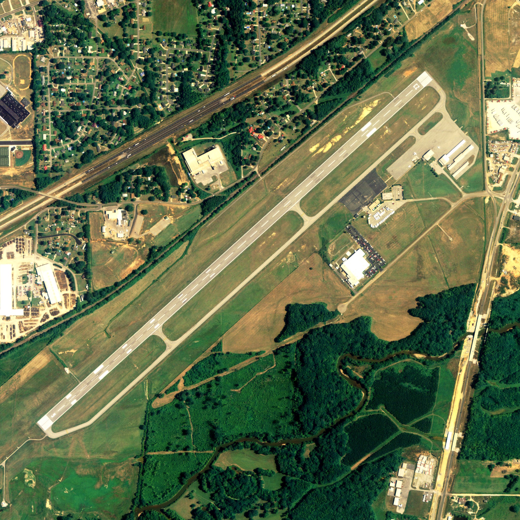
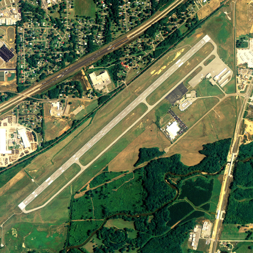
Anniston Metropolitan Airport |
| Anniston Metropolitan Airport |
 |
| IATA: ANB – ICAO: KANB – FAA LID: ANB |
| Summary |
| Airport type |
Public |
| Owner |
City of Anniston |
| Serves |
Anniston, Alabama |
| Elevation AMSL |
612 ft / 187 m |
| Coordinates |
33°35′17″N 085°51′29″W / 33.58806°N 85.85806°W / 33.58806; -85.85806 |
| Runways |
| Direction |
Length |
Surface |
| ft |
m |
| 5/23 |
7,000 |
2,134 |
Asphalt |
| Statistics (2006) |
| Aircraft operations |
34,164 |
| Based aircraft |
74 |
| Source: Federal Aviation Administration |
Anniston Metropolitan Airport (IATA: ANB, ICAO: KANB, FAA LID: ANB) is a public airport located five miles (8 km) southwest of the central business district of Anniston, a city in Calhoun County, Alabama, United States. It is owned by the City of Anniston. Facilities and aircraft
Anniston Metropolitan Airport covers an area of 627 acres (254 ha) which contains one asphalt paved runway (5/23) measuring 7,000 x 150 ft (2,134 x 46 m).
For the 12-month period ending January 31, 2006, the airport had 34,164 aircraft operations, an average of 93 per day: 72% general aviation, 14% military, 14% air taxi and <1% scheduled commercial. There are 74 aircraft based at this airport: 65% single engine, 24% multi-engine, 8% jet aircraft and 3% helicopters.
Incidents and accidents
Anniston Metropolitan Airport was the intended destination of GP Express Flight 861 which crashed about 7.5 miles northeast of the airport on June 8, 1992.
The above content comes from Wikipedia and is published under free licenses – click here to read more.
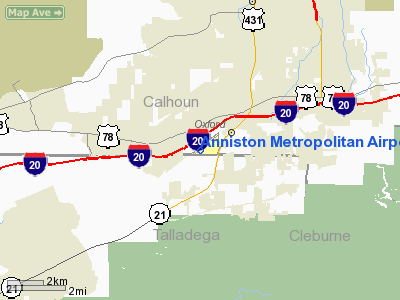
Location
& QuickFacts
| FAA Information Effective: |
2005-10-27 |
| Airport Identifier: |
ANB |
| Longitude/Latitude: |
085-51-29.2000W/33-35-17.4000N
-85.858111/33.588167 (Estimated) |
| Elevation: |
612
ft / 186.54 m (Surveyed) |
| Land: |
627
acres |
| From nearest city: |
5
nautical miles SW of Anniston, AL |
| Location: |
Calhoun
County, AL |
| Magnetic Variation: |
01W
(1985) |
Owner
& Manager
| Ownership: |
Publicly
owned |
| Owner: |
City
Of Anniston |
| Address: |
P.o.
Box 2185
Anniston, AL 36202 |
| Phone number: |
256-831-4410 |
| Manager: |
Nathan
C. Denton, Iii |
| Address: |
Box
2185
Anniston, AL 36202 |
| Phone number: |
256-831-4410 |
Airport
Operations and Facilities
|
Airport Use: |
Open
to public |
| Wind indicator: |
Yes |
| Segmented Circle: |
Yes |
| Control Tower: |
No |
| Attendance Schedule: |
ALL/ALL/0730-1800 |
| Lighting Schedule: |
DUSK-DAWN
FOR MALSR RY 05, HIRL RY 05/23, PAPI RYS 05 & 23,
AND REIL RY 23 CTC ANNISTON AFSS. |
| Beacon Color: |
Clear-Green
(lighted land airport) |
| Landing fee charge: |
No |
| Sectional chart: |
Atlanta |
| Region: |
ASO
- Southern |
| Boundary ARTCC: |
ZTL
- Atlanta |
| Tie-in FSS: |
ANB
- Anniston |
| FSS on Airport: |
Yes |
| FSS Phone: |
256-832-2100 |
| FSS Toll Free: |
1-800-WX-BRIEF |
| NOTAMs Facility: |
ANB
(NOTAM-d service avaliable) |
| Certification type/date: |
AS
5/1973
CLSD TO ACR OPNS WITH MORE THAN 30 PSGR SEATSEXCP PPR
CALL (256) 831-4410. INDEX B ARFF EQUIPMENT AVAILABLE
ALL HOURS. |
| Federal Agreements: |
NGY |
Airport
Communications
|
CTAF: |
123.600 |
| Unicom: |
123.000
|
Airport
Services
|
Fuel available: |
100LLA
FOR FUEL AFT HRS CALL 256-835-6003. SVC FEE 1900-0730. |
| Airframe Repair: |
MAJOR |
|
Power Plant Repair: |
MAJOR |
| Bottled Oxygen: |
NONE |
| Bulk Oxygen: |
LOW |
Runway
Information
Runway 05/23
| Dimension: |
7000
x 150 ft / 2133.6 x 45.7 m |
| Surface: |
ASPH,
Good Condition |
| Surface Treatment: |
Saw-cut
or plastic Grooved |
| Weight Limit: |
Single
wheel: 90000 lbs.
Dual wheel: 160000 lbs.
Dual tandem wheel: 260000 lbs.
Dual dual tandem wheel: 620000 lbs. |
| Edge Lights: |
High |
| |
Runway
05 |
Runway
23 |
| Longitude: |
085-52-00.1784W |
085-50-58.2428W |
| Latitude: |
33-34-54.4447N |
33-35-40.3669N |
| Elevation: |
595.00
ft |
612.00
ft |
| Alignment: |
48 |
127 |
| ILS Type: |
ILS |
|
| Traffic Pattern: |
Right |
Left |
| Markings: |
Non-precision
instrument, Poor Condition
MARKINGS BADLY FADED |
Non-precision
instrument, Poor Condition
MARKINGS BADLY FADED |
| VASI: |
4-light
PAPI on left side |
4-light
PAPI on left side |
| Approach lights: |
MALSR |
|
| Runway End Identifier: |
|
Yes |
| Obstruction: |
,
50:1 slope to clear |
40
ft trees, 2180.0 ft from runway, 75 ft left of centerline,
25:1 slope to clear |
|
Radio
Navigation Aids
| ID |
Type |
Name |
Ch |
Freq |
Var |
Dist |
| PLR |
NDB |
Pell
City |
|
257.00 |
01E |
19.7
nm |
| SCD |
NDB |
Sylacauga |
|
284.00 |
03W |
33.9
nm |
| GPQ |
NDB |
Carrollton |
|
278.00 |
02W |
36.4
nm |
| DER |
NDB |
Alexander
City |
|
382.00 |
01W |
42.9
nm |
| ARF |
NDB |
Saratoga |
|
296.00 |
02W |
43.9
nm |
| BH |
NDB |
Mcden |
|
224.00 |
01W |
49.7
nm |
| TDG |
VOR/DME |
Talladega |
025X |
108.80 |
02E |
9.3
nm |
| GAD |
VOR/DME |
Gadsden |
070X |
112.30 |
02E |
25.9
nm |
| LGC |
VORTAC |
Lagrange |
103X |
115.60 |
01E |
46.1
nm |
| BHM |
VOT |
Birmingham
Muni |
|
110.00 |
|
45.0
nm |
Remarks
- FOR
FBO SVCS DURG ARPT ATTENDANCE HRS CALL 256-847-8417.
Anniston Metropolitan Airport
Calhoun
County, AL
Tel:
256-831-4410
Images and information placed above are from
http://www.airport-data.com/airport/ANB/
We thank them for the data!
| General Info
|
| Country |
United States
|
| State |
ALABAMA
|
| FAA ID |
ANB
|
| Latitude |
33-35-17.400N
|
| Longitude |
085-51-29.200W
|
| Elevation |
612 feet
|
| Near City |
ANNISTON
|
We don't guarantee the information is fresh and accurate. The data may be wrong or outdated.
For more up-to-date information please refer to other sources.
|
|