 |
|
South Alabama Regional Airport
Bill Benton Field |
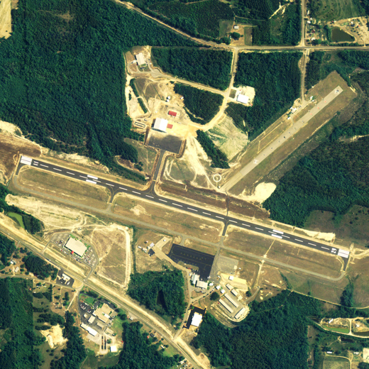 |
| NAIP aerial image, 29 June 2006 |
| IATA: none – ICAO: none – FAA LID: 79J |
| Summary |
| Airport type |
Public |
| Owner |
Andalusia-Opp Airport Authority |
| Serves |
Andalusia & Opp, Alabama |
| Elevation AMSL |
310 ft / 94 m |
| Coordinates |
31°18′32″N 086°23′38″W / 31.30889°N 86.39389°W / 31.30889; -86.39389 |
| Runways |
| Direction |
Length |
Surface |
| ft |
m |
| 11/29 |
5,000 |
1,524 |
Asphalt |
| Statistics (2006) |
| Aircraft operations |
62,750 |
| Based aircraft |
24 |
| Source: Federal Aviation Administration |
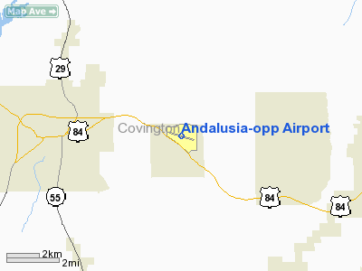
South Alabama Regional Airport at Bill Benton Field (FAA LID: 79J), formerly known as Andalusia-Opp Airport, is a public airport located four miles (6 km) east of the central business district of Andalusia and approx. 9 miles (14 km) west of Opp, both cities in Covington County, Alabama, United States. According to the FAA's National Plan of Integrated Airport Systems for 2009–2013, it is categorized as a general aviation facility.
The Andalusia-Opp Airport Authority voted in May 2007 to change the name of the airport to South Alabama Regional Airport. It was also announced the same month that the airport had received a grant from the U.S. Department of Transportation to extend the runway from 5,000 to 6,000 feet (1,800 m).
Facilities and aircraft
South Alabama Regional Airport covers an area of 550 acres (223 ha) which contains one asphalt paved runway (11/29) measuring 5,001 x 100 ft (1,524 x 30 m).
For the 12-month period ending June 16, 2006, the airport had 62,750 aircraft operations, an average of 171 per day: 81% military and 19% general aviation. There are 24 aircraft based at this airport: 75% single engine, 8% multi-engine and 17% helicopters.
The above content comes from Wikipedia and is published under free licenses – click here to read more.
Location
& QuickFacts
| FAA Information Effective: |
2005-10-27 |
| Airport Identifier: |
79J |
| Longitude/Latitude: |
086-23-37.6000W/31-18-31.5000N
-86.393778/31.308750 (Estimated) |
| Elevation: |
310
ft / 94.49 m (Surveyed) |
| Land: |
550
acres |
| From nearest city: |
4
nautical miles E of Andalusia/opp, AL |
| Location: |
Covington
County, AL |
| Magnetic Variation: |
02W
(2005) |
Owner
& Manager
| Ownership: |
Publicly
owned |
| Owner: |
Andalusia
Arpt Auth |
| Address: |
Route
3 Box 58
Andalusia, AL 36420 |
| Phone number: |
334-222-6598 |
| Manager: |
Bill
Benton |
| Address: |
Route
3 Box 58
Andalusia, AL 36420 |
| Phone number: |
334-222-6598 |
Airport
Operations and Facilities
| Airport Use: |
Open
to public |
| Wind indicator: |
Yes |
| Segmented Circle: |
Yes |
| Control Tower: |
Yes |
| Attendance Schedule: |
ALL/MON-FRI/0730-1900,ALL/SAT-SUN/0900-1700
LATER HRS AVBL; CALL 334-222-6234/1294. |
| Lighting Schedule: |
DUSK-DAWN
WHEN TWR CLSD ACTVT MIRL RY 11/29 & VASI RYS 11 &
29 - 119.55. |
| Beacon Color: |
Clear-Green
(lighted land airport) |
| Landing fee charge: |
No |
| Sectional chart: |
New
Orleans |
| Region: |
ASO
- Southern |
| Boundary ARTCC: |
ZJX
- Jacksonville |
| Tie-in FSS: |
ANB
- Anniston |
| FSS on Airport: |
No |
| FSS Phone: |
256-832-2100 |
| FSS Toll Free: |
1-800-WX-BRIEF |
| NOTAMs Facility: |
79J
(NOTAM-d service avaliable) |
| Federal Agreements: |
NGY |
Airport
Communications
| CTAF: |
119.550 |
| Unicom: |
122.800
|
Airport
Services
| Fuel available: |
100LLA
MILITARY CONTRACT FUEL AVBL MON-FRI 0700-0000, SAT & SUN
0800-1800, OTHER TIMES CALL (334) 222-0638. |
| Bottled Oxygen: |
NONE |
| Bulk Oxygen: |
NONE |
Runway
Information
Runway 11/29
| Dimension: |
5001
x 100 ft / 1524.3 x 30.5 m |
| Surface: |
ASPH,
Good Condition |
| Weight Limit: |
Single
wheel: 30000 lbs. |
| Edge Lights: |
Medium |
| |
Runway
11 |
Runway
29 |
| Longitude: |
086-24-05.1583W |
086-23-09.9337W |
| Latitude: |
31-18-38.5271N |
31-18-24.3969N |
| Elevation: |
309.00
ft |
305.00
ft |
| Alignment: |
107 |
127 |
| Traffic Pattern: |
Left |
Left |
| Markings: |
Non-precision
instrument, Good Condition |
Non-precision
instrument, Good Condition |
| Crossing Height: |
0.00
ft |
40.00
ft |
| VASI: |
4-box
on left side |
4-box
on left side |
| Visual Glide Angle: |
0.00� |
3.00� |
| Obstruction: |
32
ft tree, 1050.0 ft from runway, 26:1 slope to clear |
43
ft trees, 1150.0 ft from runway, 65 ft right of centerline,
22:1 slope to clear |
|
Radio
Navigation Aids
| ID |
Type |
Name |
Ch |
Freq |
Var |
Dist |
| JUY |
NDB |
Judd |
|
264.00 |
02W |
0.3
nm |
| XBR |
NDB |
Brantley |
|
410.00 |
00E |
16.1
nm |
| BVG |
NDB |
Boll
Weevil |
|
352.00 |
03E |
21.1
nm |
| OZ |
NDB |
Ruckr |
|
212.00 |
00E |
30.1
nm |
| XNE |
NDB |
Spring
Hill |
|
281.00 |
00E |
31.2
nm |
| LOR |
NDB |
Lowe |
|
269.00 |
03W |
33.5
nm |
| PRN |
NDB |
Persimmon/dcmsnd |
|
359.00 |
00E |
34.5
nm |
| TO |
NDB |
Blood |
|
365.00 |
01W |
34.7
nm |
| HYE |
NDB |
Hanchey |
|
221.00 |
00E |
38.3
nm |
| BKK |
NDB |
Tri
County |
|
275.00 |
02W |
49.2
nm |
| NSE |
TACAN |
Whiting |
070X |
|
01E |
47.6
nm |
| EDN |
VOR |
Enterprise |
|
116.60 |
03W |
25.2
nm |
| HEY |
VOR |
Hanchey |
|
110.60 |
02E |
38.2
nm |
| FYL |
VOR |
Tri
County |
|
108.40 |
08W |
49.2
nm |
| OZR |
VOR/DME |
Cairns |
049X |
111.20 |
02E |
34.4
nm |
| CEW |
VORTAC |
Crestview |
106X |
115.90 |
03E |
32.5
nm |
| RRS |
VORTAC |
Wiregrass |
053X |
111.60 |
02E |
49.5
nm |
Remarks
- WX
OBSERVER AVBL 1430-2230Z++, MON-FRI, EXC HOL. CTC CAIRNS AAF FOR
FCST SVC 0600Z++ MON-0700Z++ SAT, EXC HOL. WX OBSN VIS RSTD E-NW.
REMOTE BRIEFING SVC AVBL 28 OWS, SHAW AFB, DSN 965-0939/43, C877-297-4129
(TOLL FREE) OR HTTP://OWS.SHAW.AF.MIL
Andalusia-opp Airport
Address:
Covington County, AL
Tel: 334-222-6598
Images and information placed above are from
http://www.airport-data.com/airport/79J/
We thank them for the data!
| General Info
|
| Country |
United States
|
| State |
ALABAMA
|
| FAA ID |
79J
|
| Latitude |
31-18-31.510N
|
| Longitude |
086-23-37.539W
|
| Elevation |
309 feet
|
| Near City |
ANDALUSIA/OPP
|
We don't guarantee the information is fresh and accurate. The data may be wrong or outdated.
For more up-to-date information please refer to other sources.
|
|


