|
|
| Abbeville Municipal Airport |
 |
| IATA: none – ICAO: none – FAA LID: 0J0 |
| Summary |
| Airport type |
Public |
| Owner |
City of Abbeville |
| Serves |
Abbeville, Alabama |
| Elevation AMSL |
468 ft / 143 m |
| Coordinates |
31°36′01″N 085°14′17″W / 31.60028°N 85.23806°W / 31.60028; -85.23806 |
| Runways |
| Direction |
Length |
Surface |
| ft |
m |
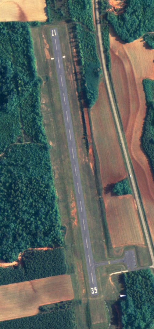
| 17/35 |
2,915 |
888 |
Asphalt |
| Statistics (2009) |
| Aircraft operations |
1,600 |
| Source: Federal Aviation Administration |
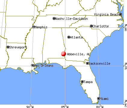
Abbeville Municipal Airport (FAA LID: 0J0) is a city-owned, public-use airport located three nautical miles (6 km) north of the central business district of Abbeville, a city in Henry County, Alabama, United States. It is the only airport that serves the city of Abbeville. As per the FAA's National Plan of Integrated Airport Systems for 2009-2013, it is classified as a general aviation airport. History
Abbeville Municipal Airport was officially activated by the FAA on August 1959.
Facilities and aircraft
Abbeville Municipal Airport covers an area of 36 acres (15 ha) at an elevation of 468 feet (143 m) above mean sea level. It has one runway designated 17/35 with an asphalt surface measuring 2,915 by 80 feet (888 x 24 m). For the 12-month period ending November 11, 2009, the airport had 1,600 aircraft operations, an average of 133 per month: 75% military and 25% general aviation.
The above content comes from Wikipedia and is published under free licenses – click here to read more.
Location
& QuickFacts
| FAA Information Effective: |
2005-10-27 |
| Airport Identifier: |
0J0 |
| Longitude/Latitude: |
085-14-19.7600W/31-36-00.6040N
-85.238822/31.600168 (Estimated) |
| Elevation: |
468 ft / 142.65 m (Surveyed) |
| Land: |
36 acres |
| From nearest city: |
3 nautical miles N of Abbeville, AL |
| Location: |
Henry County, AL |
| Magnetic Variation: |
01W (1985) |
Owner & Manager
| Ownership: |
Publicly owned |
| Owner: |
City Of Abbeville |
| Address: |
Po Box 427
Abbeville, AL 36310 |
| Phone number: |
334-585-6444 |
| Manager: |
Jim Giganti |
| Address: |
Po Box 427
Abbeville, AL 36310 |
| Phone number: |
334-585-6444 |
Airport Operations and Facilities
| Airport Use: |
Open to public |
| Wind indicator: |
Yes |
| Segmented Circle: |
No |
| Control Tower: |
No |
| Attendance Schedule: |
UNATNDD |
| Lighting Schedule: |
DUSK-DAWN |
| Landing fee charge: |
No |
| Sectional chart: |
New Orleans |
| Region: |
ASO - Southern |
| Boundary ARTCC: |
ZJX - Jacksonville |
| Tie-in FSS: |
ANB - Anniston |
| FSS on Airport: |
No |
| FSS Phone: |
256-832-2100 |
| FSS Toll Free: |
1-800-WX-BRIEF |
| NOTAMs Facility: |
ANB (NOTAM-d service avaliable) |
| Federal Agreements: |
N |
Airport Communications
| CTAF: |
122.800 |
| Unicom: |
122.800
UNICOM IS LCTD AT POLICE STATION. |
Airport Services
| Airframe Repair: |
NONE |
| Power Plant Repair: |
NONE |
Radio Navigation Aids
| ID |
Type |
Name |
Ch |
Freq |
Var |
Dist |
| HYE |
NDB |
Hanchey |
|
221.00 |
00E |
25.3 nm |
| LOR |
NDB |
Lowe |
|
269.00 |
03W |
29.6 nm |
| OZ |
NDB |
Ruckr |
|
212.00 |
00E |
37.2 nm |
| XNE |
NDB |
Spring Hill |
|
281.00 |
00E |
38.0 nm |
| BVG |
NDB |
Boll Weevil |
|
352.00 |
03E |
41.3 nm |
| AWS |
NDB |
Lawson |
|
335.00 |
02W |
43.1 nm |
| SMY |
NDB |
Soyya |
|
329.00 |
02W |
43.8 nm |
| TO |
NDB |
Blood |
|
365.00 |
01W |
46.4 nm |
| BKK |
NDB |
Tri County |
|
275.00 |
02W |
48.7 nm |
| HEY |
VOR |
Hanchey |
|
110.60 |
02E |
25.2 nm |
| EDN |
VOR |
Enterprise |
|
116.60 |
03W |
38.7 nm |
| FYL |
VOR |
Tri County |
|
108.40 |
08W |
49.4 nm |
| OZR |
VOR/DME |
Cairns |
049X |
111.20 |
02E |
32.0 nm |
| LSF |
VOR/DME |
Lawson |
051X |
111.40 |
02W |
45.8 nm |
| RRS |
VORTAC |
Wiregrass |
053X |
111.60 |
02E |
21.4 nm |
| EUF |
VORTAC |
Eufaula |
029X |
109.20 |
02E |
21.8 nm |
| PZD |
VORTAC |
Pecan |
108X |
116.10 |
02W |
48.5 nm |
| MAI |
VORTAC |
Marianna |
087X |
114.00 |
00E |
49.3 nm |
Remarks
- EXISTED PRIOR TO MAY 15, 1959.
Abbeville City Airport
Abbeville City Airport
RR 1
Abbeville, AL 36310-9801
Tel: (334) 585-5888
Images and information placed above are from
http://national.citysearch.com/profile/1464512/?brand=smx_yp-nc
http://www.city-data.com/city/Abbeville-Alabama.html
http://www.airport-data.com/airport/0J0/
We thank them for the data!
| General Info
|
| Country |
United States
|
| State |
ALABAMA
|
| FAA ID |
0J0
|
| Latitude |
31-36-00.604N
|
| Longitude |
085-14-19.760W
|
| Elevation |
468 feet
|
| Near City |
ABBEVILLE
|
We don't guarantee the information is fresh and accurate. The data may be wrong or outdated.
For more up-to-date information please refer to other sources.
|
|