 |
 |
|
||||
|
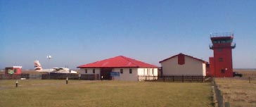
Tiree Airport is located on the south east coast of the island, which regularly records the highest annual levels of sunshine in the UK. The island�s coastal waters are also famed as a top location for surfing events. Aircraft operations are supported by a Flight Information Service. An Airport Fire Service is provided on the basis of a Rescue and Fire Fighting Service category 3 airport, as detailed in Civil Aviation Publication 168. Airport Information Facilities for the Disabled There are ramp facilities at the terminal entrance and staff are always available to assist. An Ambulift is provided to transfer non-walking passengers onto/off the scheduled aircraft. Located on the southeast coast of the island famed for its surf and sunshine, this small airport offers one scheduled flight to and from Glasgow by Logan Air along with regular charter flights. The single terminal building is open from 10:00-15:00 Monday - Friday and 09:30-11:00 on Saturdays, while it normally remains closed on Sundays. The terminal contains a small cafe serving snacks and refreshments and a convenience store stocking basic needs and reading material. There are no financial or business facilities. Facilities for disabled passengers include ramps, wide doorways, dedicated parking, and specially designed toilets. The postal bus stops at the airport once a day and will transport passengers to Scarinish. Taxis are available from outside the terminal, call J Gorman +44 (0) 1879 220344 or A MacKechnie +44 (0) 1879 220419. Car hire is also available, call MacLennans +44 (0) 1879 220555 or Tiree Motor Co +44 (0) 1879 220469. The airport is situated on the B8066, two miles north of Crossapol. Both short- and long-stay parking is available.
Images and information placed above are from http://www.machairhouse.homestead.com/tiree.html http://www.users.zetnet.co.uk/mbriscoe/ToC.htm http://www.worldparking.co.uk/uk-airports/tiree.php We thank them for the data!
Runway 05/234600 x 98 feet
|
||||||||||||||||||||||||||||||||||||||||||||||||||||||||||||||||||||||||||||||||||||||||||||||||||||||||||||||||||||||||||||||||||||||||||||||||||||||||||||||||||||||||||||||||||||||||||||||||||||||||||||||||||||||||||||||||||||||||||||||||||||||||||||||
| Runway 05 | |
|---|---|
| Surface | ASPHALT |
| True Heading | 047.0 |
| Latitude | 56.495039 56° 29' 42.14" N |
| Longitude | -6.877192 006° 52' 37.89" W |
| Elevation | 30.0 feet 9 meters |
| Slope | -0.2° |
| Landing Distance | 4600 feet 1402 meters |
| Takeoff Distance | 4600 feet 1402 meters |
| Lighting System | PAPI
PORTABLE |
| Runway 23 | |
|---|---|
| Surface | ASPHALT |
| True Heading | 227.0 |
| Latitude | 56.503611 56° 30' 13.00" N |
| Longitude | -6.860519 006° 51' 37.87" W |
| Elevation | 20.0 feet 6 meters |
| Slope | 0.2° |
| Landing Distance | 4429 feet 1350 meters |
| Takeoff Distance | 4830 feet 1472 meters |
| Displaced Threshold Length | 171 feet 52 meters |
| Overrun Length | 230 feet 70 meters |
| Overrun Surface | ASPHALT |
| Lighting System | PAPI
PORTABLE |
| Runway 11 | |
|---|---|
| Surface | ASPHALT |
| True Heading | 110.0 |
| Latitude | 56.502778 56° 30' 10.00" N |
| Longitude | -6.879444 006° 52' 46.00" W |
| Elevation | 38.0 feet 12 meters |
| Slope | -0.5° |
| Landing Distance | 2690 feet 820 meters |
| Takeoff Distance | 2690 feet 820 meters |
| Lighting System | PORTABLE |
| Runway 29 | |
|---|---|
| Surface | ASPHALT |
| True Heading | 290.0 |
| Latitude | 56.500278 56° 30' 01.00" N |
| Longitude | -6.866667 006° 52' 00.00" W |
| Elevation | 24.0 feet 7 meters |
| Slope | 0.5° |
| Landing Distance | 2690 feet 820 meters |
| Takeoff Distance | 2690 feet 820 meters |
| Lighting System | PORTABLE |
| Runway 17 | |
|---|---|
| Surface | CONCRETE. |
| True Heading | 168.0 |
| Latitude | 56.507500 56° 30' 27.00" N |
| Longitude | -6.877500 006° 52' 39.00" W |
| Elevation | 33.0 feet 10 meters |
| Slope | 0.2° |
| Landing Distance | 1968 feet 600 meters |
| Takeoff Distance | 1968 feet 600 meters |
| Runway 35 | |
|---|---|
| Surface | CONCRETE. |
| True Heading | 348.0 |
| Latitude | 56.502222 56° 30' 08.00" N |
| Longitude | -6.875556 006° 52' 32.00" W |
| Elevation | 36.0 feet 11 meters |
| Slope | -0.2° |
| Landing Distance | 1968 feet 600 meters |
| Takeoff Distance | 1968 feet 600 meters |
| TIREE | |||||
|---|---|---|---|---|---|
| Type | ID | Channel | Freq | Country | State |
| VOR-DME | TIR | 124X | 117.7 | United Kingdom | - |
| Latitude | Longitude | Airport |
| 56.493167 56° 29' 35.40" N |
-6.875556 006° 52' 32.00" W |
EGPU |
The content above was published at Airports-Worldwide.com in 2005.
We don't guarantee the information is fresh and accurate. The data may be wrong or outdated.
For more up-to-date information please refer to other sources.

 |
|
Copyright 2004-2026 © by Airports-Worldwide.com, Vyshenskoho st. 36, Lviv 79010, Ukraine Legal Disclaimer |
 Aircraft and Helicopter Charter