 |
 |
|
||||
|
With its friendly stress-free atmosphere, Shoreham Airport offers all the requirements for modern aviation including, executive and business aviation, flight instruction, pleasure flights, as well as provides excellent Conference and Meeting facilities. Hire our 10acre site! Go further into our web site to find out more. There are two licensed restaurants, Terminal 2 at Wingfield House and the Fly-In Bar and Restaurant within the main Terminal Building. Shoreham being the oldest licensed airfield in the UK, has a beautiful Grade II listed art deco style Terminal Building, the outside viewing areas offer an exciting opportunity to enjoy aviation in a pleasant environment, with the Airport�s Visitor Centre a must for a family outing. The Centre can organise Guided tours for anyone wishing to see and hear the history of the airfield. HISTORY:
During 1935 the Croydon based company Olley Air Services Ltd., was appointed to manage the aerodrome and a service, Croydon-Shoreham-Deauville was started on the l3th July. On the 13th June 1936 this exquisite art-deco Terminal Building was officially opened by the Mayors of Brighton, Hove and Worthing. The building remains today very much in its original shape and as always, is still very much open to the public. The opening day at Shoreham hosted an air-show and companies such as Channel Air Ferries, Railway Air Services and Jersey Airways soon started to use the airport. Within the Terminal Building's long history, it has seen international and domestic departures and arrivals including some of the world's largest airlines. With the outbreak of war in 1939 international airline operators were removed from London (Croydon) Airport to Shoreham. These include names like Sabena, DDL, KLM and the predecessor of British Airways, Imperial Airways. Some of the destinations flown to by the above airlines included Copenhagen, Amsterdam, Malmo and Brussels. Shoreham Airport is still at the forefront of general aviation in this country. The Terminal Building is now a Grade II listed building and is still in every day use by business, training and pleasure fliers alike including many visitors from Europe. Many of the fixtures are original including the Whispering Gallery on the first floor and the main window design above the main entrance.
Images and information placed above are from http://news.bbc.co.uk/ We thank them for the data!
Runway 02/203399 x 59 feet
|
||||||||||||||||||||||||||||||||||||||||||||||||||||||||||||||||||||||||||||||||||||||||||||||||||||||||||||||||||||||||||||||||||||||||||||||||||||||||||||||||||||||||||||||||||||||||||||||||||||||||||||||||||||||||||
| Runway 02 | |
|---|---|
| Surface | ASPHALT |
| True Heading | 022.0 |
| Latitude | 50.831992 50° 49' 55.17" N |
| Longitude | -0.299531 000° 17' 58.31" W |
| Elevation | 7.0 feet 2 meters |
| Landing Distance | 3106 feet 947 meters |
| Takeoff Distance | 3399 feet 1036 meters |
| Displaced Threshold Length | 293 feet 89 meters |
| Lighting System | LIRL
PAPI |
| Runway 20 | |
|---|---|
| Surface | ASPHALT |
| True Heading | 202.0 |
| Latitude | 50.839883 50° 50' 23.58" N |
| Longitude | -0.294594 000° 17' 40.54" W |
| Elevation | 7.0 feet 2 meters |
| Landing Distance | 3086 feet 941 meters |
| Takeoff Distance | 3399 feet 1036 meters |
| Displaced Threshold Length | 313 feet 95 meters |
| Lighting System | LIRL
PAPI |
| Runway 07 | |
|---|---|
| Surface | GRADED OR ROLLED EARTH, GRASS ON GRADED EARTH. |
| True Heading | 064.0 |
| Latitude | 50.832578 50° 49' 57.28" N |
| Longitude | -0.300292 000° 18' 01.05" W |
| Elevation | 6.0 feet 2 meters |
| Slope | 0.0° |
| Landing Distance | 2877 feet 877 meters |
| Takeoff Distance | 2877 feet 877 meters |
| Runway 25 | |
|---|---|
| Surface | GRADED OR ROLLED EARTH, GRASS ON GRADED EARTH. |
| True Heading | 244.0 |
| Latitude | 50.836161 50° 50' 10.18" N |
| Longitude | -0.288933 000° 17' 20.16" W |
| Elevation | 6.0 feet 2 meters |
| Slope | 0.0° |
| Landing Distance | 2877 feet 877 meters |
| Takeoff Distance | 2877 feet 877 meters |
| Runway 13 | |
|---|---|
| Surface | GRADED OR ROLLED EARTH, GRASS ON GRADED EARTH. |
| True Heading | 124.0 |
| Latitude | 50.838333 50° 50' 18.00" N |
| Longitude | -0.295000 000° 17' 42.00" W |
| Elevation | 7.0 feet 2 meters |
| Slope | -0.1° |
| Landing Distance | 1312 feet 400 meters |
| Takeoff Distance | 1312 feet 400 meters |
| Runway 31 | |
|---|---|
| Surface | GRADED OR ROLLED EARTH, GRASS ON GRADED EARTH. |
| True Heading | 304.0 |
| Latitude | 50.836342 50° 50' 10.83" N |
| Longitude | -0.290272 000° 17' 24.98" W |
| Elevation | 6.0 feet 2 meters |
| Slope | 0.1° |
| Landing Distance | 1312 feet 400 meters |
| Takeoff Distance | 1312 feet 400 meters |
The content above was published at Airports-Worldwide.com in 2005.
We don't guarantee the information is fresh and accurate. The data may be wrong or outdated.
For more up-to-date information please refer to other sources.

 |
|
Copyright 2004-2026 © by Airports-Worldwide.com, Vyshenskoho st. 36, Lviv 79010, Ukraine Legal Disclaimer |
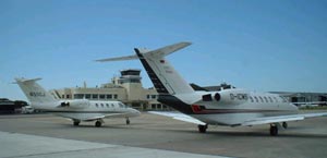 Shoreham Airport at the forefront of general aviation in the UK, and a major base for flying activities on the South Coast. Serving the South Coast, the City of Brighton & Hove and the town of Worthing are both within a short drive of the Airport. The airport benefits from direct access from the main A27, and a main line rail station is within easy reach.
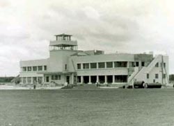 In 1930 the municipal authorities of Brighton, Hove and Worthing formed a joint committee to establish Shoreham as the municipal airport for three towns. Construction on the Terminal Building began in November 1934.
 Shoreham Airport: