 |
 |
|
||||
|
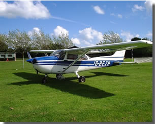
The aircraft used is a Cessna 172. Ideally suited for this type of operation, it has a high wing, offering a relatively unobstructed view of the ground, suitable for not only pleasure flights, but aerial survey and photographic duties. Although a small airport, Sandown has excellent facilities for visiting pilots. The Island has many attractions within a short distance from the airfield making it an interesting cross country destination. For those flying onto the Continent or Channel Islands the aerodrome is an ideal start destination. Assistance is available for flight planning, weather, customs, police, immigration clearance, and fuel drawback (currently 27.34 pence per litre on all fuel loaded before departure). The Reach for the Pie cafe at Sandown is open during airfield operational hours, offering quality beverages and light snacks.
Images and information placed above are from http://www.bigginhill.co.uk/airport.htm We thank them for the data! Aerodrome Information Operating Hours: 23 all distances 884 metres 05 as 23 except LDA 775 metres Black and white wingbars emphasise the position of landing thresholds Geographical position: Elevation 60 feet AMSL C.A.A. Licensed Category 2D Prior Permission Only (Telephone or Radio call). Fire service Cat. 1. Aerodrome Code EGHN Sampton VOR (SAM) 113.35 MHz bearing to field 167� M Bembridge NDB (IW) 426 MHz bearing outbound to field 249� M Mast 1299 ft AMSL 6NM bearing 275� M from field. Mast 950 ft AMSL 7NM bearing 290� M from field. Note: Gliding may take place from this field. Goodwood 20 NM NE Radio 122.45 Southampton 19 NM Solent Radar 120.225 The content above was published at Airports-Worldwide.com in 2005. |

 |
|
Copyright 2004-2026 © by Airports-Worldwide.com, Vyshenskoho st. 36, Lviv 79010, Ukraine Legal Disclaimer |
 Birnie Air Services was formed in 1992, and has been offering aerial tours of the Isle of Wight, daily throughout the summer months.