 |
 |
|
||||
|
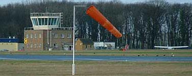
Kemble will be strictly PPR on the day of the airshow and arrival slots will be limited; your slot needs to be booked and paid for in advance. Please see here for airfield details. Note that runway 31 hard will NOT be available on the weekend of the airshow. Kemble Air Day The Kemble Air Day brings you the very best examples of vintage jets and warbirds together at one airfield to display for you along with modern RAF types, including the Red Arrows. One of this year's themes will be a celebration of the Royal Air Force Jaguar, which will be retired in early 2006. 2005 will therefore see the final public displays of the type and Kemble is privileged enough to have been allocated a Jaguar display. With a three and a half hour long flying display including warbirds, vintage jets, modern jets and of course the RAF Red Arrows, the Kemble Air Day will thrill and entertain young and old alike. Ground attractions will include static aircraft, trade stands and exhibitions, a vintage and military vehicle display, refreshments and a fun fair. Kemble Air Services Ltd The Control Tower, Kemble Airfield, Kemble Ind Park, Kemble, Cirencester Gloucestershire England GL7 6BA Tel: 01285 771076 Fax: 01285 771414 E-mail: ops at kemble com WWW: Kemble Airfield
Images and information placed above are from http://airline-tickets.co.uk/kemble-air-services-ltd.htm http://www.controltowers.co.uk/H-K/Kemble.htm We thank them for the data!
Runway 03/211148 x 66 feet
|
|||||||||||||||||||||||||||||||||||||||||||||||||||||||||||||||||||||||||||||||||||||||||||||||||||||||||||||||||||||||||||||||||||||||||||||||||||||||||||||||||||||||||||||||||||||||||||||||||||||||||||||||||||||||||||||||||||||||||||
| Runway 03 | |
|---|---|
| Surface | GRASS OR EARTH NOT GRADED OR ROLLED. |
| True Heading | 036.0 |
| Latitude | 0.000000 - |
| Longitude | 0.000000 - |
| Landing Distance | 1148 feet 350 meters |
| Takeoff Distance | 1148 feet 350 meters |
| Runway 21 | |
|---|---|
| Surface | GRASS OR EARTH NOT GRADED OR ROLLED. |
| True Heading | 216.0 |
| Latitude | 0.000000 - |
| Longitude | 0.000000 - |
| Landing Distance | 1148 feet 350 meters |
| Takeoff Distance | 1148 feet 350 meters |
| Runway 08 | |
|---|---|
| Surface | ASPHALT |
| True Heading | 080.0 |
| Latitude | 51.666583 51° 39' 59.70" N |
| Longitude | -2.071081 002° 04' 15.89" W |
| Landing Distance | 6030 feet 1838 meters |
| Takeoff Distance | 6591 feet 2009 meters |
| Displaced Threshold Length | 561 feet 171 meters |
| Lighting System | LIRL
PAPI |
| Runway 26 | |
|---|---|
| Surface | ASPHALT |
| True Heading | 260.0 |
| Latitude | 51.669594 51° 40' 10.54" N |
| Longitude | -2.042431 002° 02' 32.75" W |
| Landing Distance | 5722 feet 1744 meters |
| Takeoff Distance | 6591 feet 2009 meters |
| Displaced Threshold Length | 869 feet 265 meters |
| Lighting System | LIRL |
| Runway 09L | |
|---|---|
| Surface | GRASS OR EARTH NOT GRADED OR ROLLED. |
| True Heading | 086.3 |
| Latitude | 0.000000 - |
| Longitude | 0.000000 - |
| Landing Distance | 1476 feet 450 meters |
| Takeoff Distance | 1476 feet 450 meters |
| Runway 27R | |
|---|---|
| Surface | GRASS OR EARTH NOT GRADED OR ROLLED. |
| True Heading | 266.3 |
| Latitude | 0.000000 - |
| Longitude | 0.000000 - |
| Landing Distance | 1476 feet 450 meters |
| Takeoff Distance | 1476 feet 450 meters |
| Runway 13 | |
|---|---|
| Surface | ASPHALT |
| True Heading | 123.0 |
| Latitude | 0.000000 - |
| Longitude | 0.000000 - |
| Elevation | 433.0 feet 132 meters |
| Slope | -0.6° |
| Landing Distance | 3087 feet 941 meters |
| Takeoff Distance | 3087 feet 941 meters |
| Runway 31 | |
|---|---|
| Surface | ASPHALT |
| True Heading | 303.0 |
| Latitude | 0.000000 - |
| Longitude | 0.000000 - |
| Elevation | 413.0 feet 126 meters |
| Slope | 0.6° |
| Landing Distance | 3087 feet 941 meters |
| Takeoff Distance | 3900 feet 1189 meters |
| Overrun Length | 813 feet 248 meters |
| Overrun Surface | ASPHALT |
The content above was published at Airports-Worldwide.com in 2005.
We don't guarantee the information is fresh and accurate. The data may be wrong or outdated.
For more up-to-date information please refer to other sources.

 |
|
Copyright 2004-2026 © by Airports-Worldwide.com, Vyshenskoho st. 36, Lviv 79010, Ukraine Legal Disclaimer |
 Kemble airfield is located in Gloucestershire just South-West of Kemble village which can be found on the A429 4 miles South-West of Cirencester, 16 miles South-East of Gloucester and 12 miles North-West of Swindon.