|
 |
|
||||
|
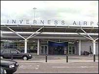
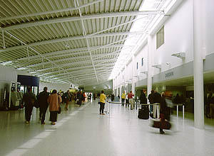
Inverness Airport is the principal air hub for the Highlands and Islands of Scotland. Located 10 miles east of the City of Inverness it offers excellent facilities to the travelling public in a modern terminal building. Daily air services between Inverness and London Gatwick, Heathrow and Luton, Manchester, Birmingham, Edinburgh, Glasgow, Kirkwall and Stornoway offer the business and leisure traveller connections throughout the UK and beyond. Inverness, capital of the Highlands, is one of the fastest growing business and social centres in the UK. The high quality of life and unrivalled natural environment in the region are major factors in the city�s success. Inverness Airport services daily scheduled links within the UK and holiday charters. It also supports a strong executive charter and freight business with aircraft from elsewhere in the UK, Europe, America and Scandinavia. Inverness Airport handled close to 500,000 passengers in 2003. Routes operated by British Airways, easyJet, Loganair, Eastern Airways, bmi and Highland Airways are offering travellers within the region better access to UK and international markets. London, Manchester and Birmingham by air are now little over an hour away. Tourism is a key market for the region and the airport offers visitors unrivalled access to the stunning scenery and unique culture of the Highlands and Islands. Onward connections from Inverness to the Orkney and Shetland Isles in the North and the Outer Hebrides in the West open up opportunities to experience these areas of outstanding beauty. Air freight movements in and out of the airport are also increasing and plans to develop a major freight and business park next to the airport are progressing. As a result of its customer focused approach to business Inverness was the first UK airport to achieve Hospitality Assured accreditation. The airport boasts a main runway measuring 1,900 metres, capable of handling B757 aircraft. An Instrument Landing System which facilitates aircraft operations in poorer weather conditions came into operation in 2004. A shorter cross�runway is used by light aircraft. Two aprons located on the west side of the airport accommodate scheduled and private aircraft. The airport has an Air Traffic Control Service and is licensed for public use. The Inverness Airport Service Promise is: "To provide a clean, safe and welcoming environment by being polite and courteous at all times and communicate relevant information clearly and swiftly."
Inverness Airport
Images and information placed above are from www.inverness-scotland.com http://www.airport-maps.co.uk/Scotland/Inverness/ http://www.loganair.co.uk/inverness_airport.htm http://www.scotsindependent.net/2003/031114 We thank them for the data!
Runway 05/236191 x 151 feet
|
|||||||||||||||||||||||||||||||||||||||||||||||||||||||||||||||||||||||||||||||||||||||||||||||||||||||||||||||||||||||||||||||||||||||||||||||||||||||||||||||||||||||||||||||||||||||||||||||||||||||||||||||||||||||||||||||||||||||||||||||||||||||||||||||||||||||
| Runway 05 | |
|---|---|
| Surface | ASPHALT |
| True Heading | 049.0 |
| Latitude | 57.536989 57° 32' 13.16" N |
| Longitude | -4.059514 004° 03' 34.25" W |
| Elevation | 29.0 feet 9 meters |
| Slope | -0.1° |
| Landing Distance | 5952 feet 1814 meters |
| Takeoff Distance | 6191 feet 1887 meters |
| Displaced Threshold Length | 239 feet 73 meters |
| Lighting System | HIRL
J PAPI |
| Runway 23 | |
|---|---|
| Surface | ASPHALT |
| True Heading | 229.0 |
| Latitude | 57.548003 57° 32' 52.81" N |
| Longitude | -4.035569 004° 02' 08.05" W |
| Elevation | 21.0 feet 6 meters |
| Slope | 0.1° |
| Landing Distance | 6191 feet 1887 meters |
| Takeoff Distance | 6191 feet 1887 meters |
| Lighting System | HIRL
J PAPI |
| Runway 12 | |
|---|---|
| Surface | ASPHALT |
| True Heading | 110.0 |
| Latitude | 57.544642 57° 32' 40.71" N |
| Longitude | -4.059869 004° 03' 35.53" W |
| Elevation | 31.0 feet 9 meters |
| Slope | -0.3° |
| Landing Distance | 2297 feet 700 meters |
| Takeoff Distance | 2297 feet 700 meters |
| Runway 30 | |
|---|---|
| Surface | ASPHALT |
| True Heading | 290.0 |
| Latitude | 57.542525 57° 32' 33.09" N |
| Longitude | -4.048811 004° 02' 55.72" W |
| Elevation | 25.0 feet 8 meters |
| Slope | 0.3° |
| Landing Distance | 2297 feet 700 meters |
| Takeoff Distance | 2297 feet 700 meters |
| INVERNESS | |||||
|---|---|---|---|---|---|
| Type | ID | Channel | Freq | Country | State |
| VOR-DME | INS | 029X | 109.2 | United Kingdom | - |
| Latitude | Longitude | Airport |
| 57.542625 57° 32' 33.45" N |
-4.041542 004° 02' 29.55" W |
EGPE |
| INVERNESS | |||||
|---|---|---|---|---|---|
| Type | ID | Channel | Freq | Country | State |
| NDB | IVR | - | 328 | United Kingdom | - |
| Latitude | Longitude | Airport |
| 57.541508 57° 32' 29.43" N |
-4.045967 004° 02' 45.48" W |
EGPE |
The content above was published at Airports-Worldwide.com in 2005.
We don't guarantee the information is fresh and accurate. The data may be wrong or outdated.
For more up-to-date information please refer to other sources.

 |
|
Copyright 2004-2026 © by Airports-Worldwide.com, Vyshenskoho st. 36, Lviv 79010, Ukraine Legal Disclaimer |