|
|
Esenboğa International Airport
Esenboğa Uluslararası Havalimanı |
 |
| IATA: ESB – ICAO: LTAC |
| Summary |
| Airport type |
Public |
| Operator |
TAV. Airport Management |
| Location |
Ankara |
| Elevation AMSL |
3,125 ft / 953 m |
| Coordinates |
40°07′41″N 032°59′42″E / 40.12806°N 32.995°E / 40.12806; 32.995 (Esenboğa International Airport)Coordinates: 40°07′41″N 032°59′42″E / 40.12806°N 32.995°E / 40.12806; 32.995 (Esenboğa International Airport) |
| Runways |
| Direction |
Length |
Surface |
| m |
ft |
| 03R/21L |
3,750 |
12,303 |
Asphalt |
| 03L/21R |
3,750 |
12,303 |
Asphalt |
| Source: Turkish AIP at EUROCONTROL |
Esenboğa International Airport (IATA: ESB, ICAO: LTAC) (Turkish: 'Ankara Esenboğa Havalimanı or Esenboğa Uluslararası Havalimanı'), is an airport located 28 km (17 mi) northeast of Ankara, the capital city of Turkey. It has been operating since 1955. The name of the airport comes from the village of Esenboğa (the g is silent), which literally means "healthy bull".
In 2009, ESB served 6,085,126 passengers, 4,987,983 of which were domestic passengers. It ranked 5th in terms of total passenger traffic, 2nd in terms of domestic traffic and 7th in terms of international traffic among airports in Turkey.
Esenboğa International Airport was awarded as the best airport in Europe by ACI Europe (Airport Council International) and the award presented to airport officials on 17 June 2009 in Manchester. The award is given in 4 categories every year and Esenboğa was in 5–10 million per annum category. It is the first time an ACI award was granted to a Turkish Airport. According to ACI-Europe, "As with number of the top candidates in this category, the airport excels in all the keys areas of operations, however the judges singled it out for its work in the area of environmental innovation, securing an incredible 25% energy savings stemming from its recycling of exhaust gases to power its air conditioning plants." LocationThe airport is located northeast of Ankara, 28 km (17 mi) from the center. The airport is connected with Kızılay (the city center) and Ankara Intercity Bus Terminal (Turkish: Ankara Şehirlerarası Terminal İşletmesi, AŞTİ) by EGO city bus number 442 (from 6 am to 11pm). Transportation to the city center is also by taxi (around TRY 45 one way, metered) and through the Havaş bus line (approximately TRY 12,5 one way). The road between Esenboğa airport and the Ankara ring road was expanded during the summer of 2006, decreasing the driving time between the city center and the airport by several minutes.
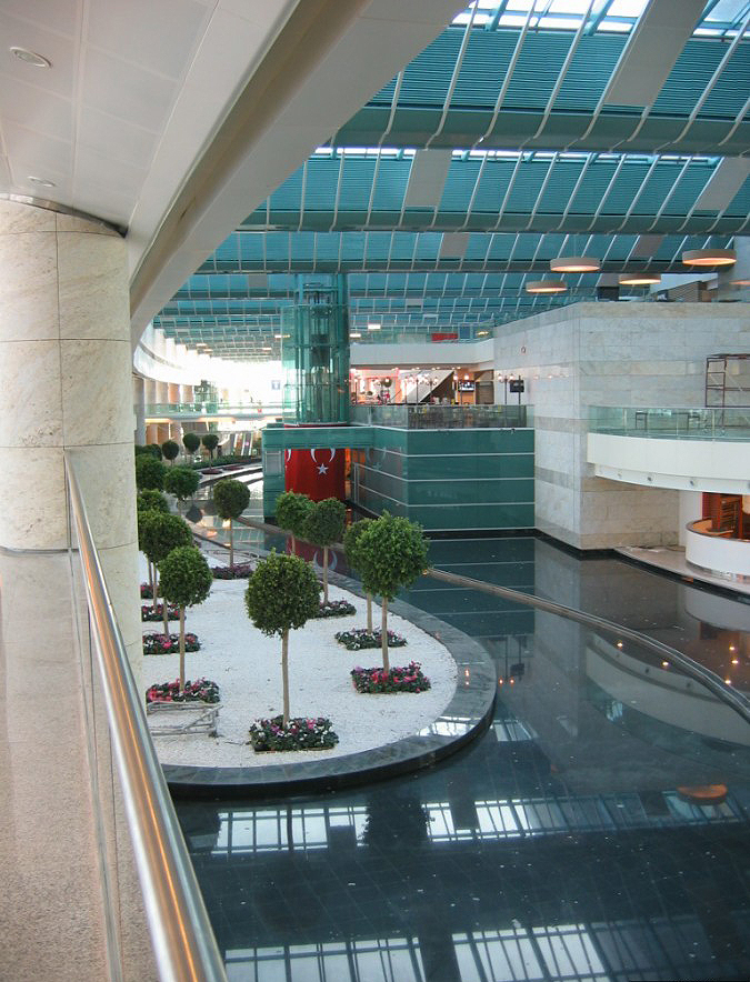
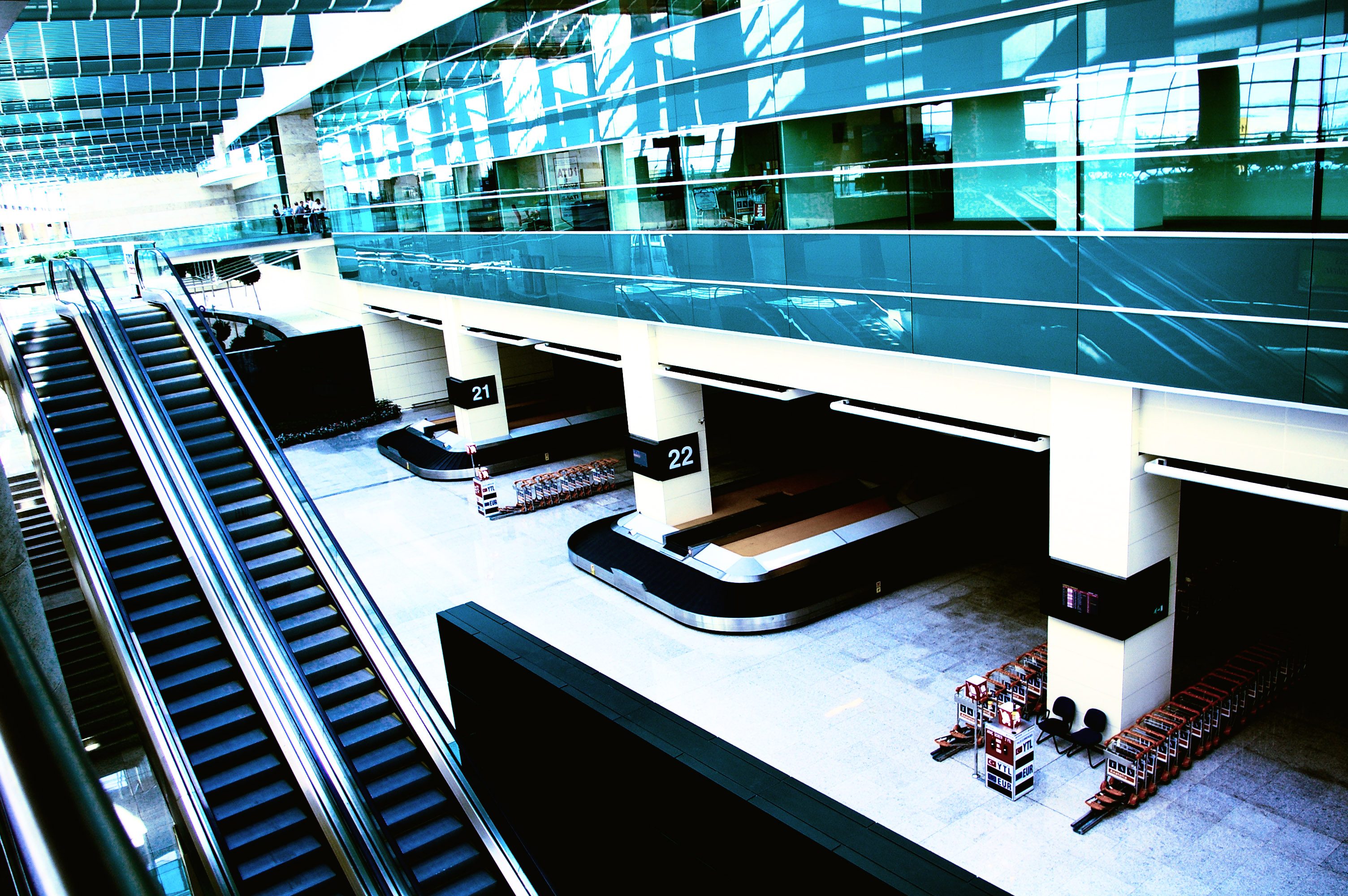
Terminals
A combined domestic and international terminal has recently opened, on October 2006, following two years of construction works.
The New Domestic and International Terminals have the properties as set below:
- 168,000 m (1,808,337 sq ft) area,
- 10,000,000 passenger/year capacity,
- 18 ea. passenger bridge,
- 105 check-in counters,
- 34 passport counters,
- Parking Facility with 123,000 m (1,323,961 sq ft) area and 4,000 vehicle capacity
Esenboga Airport New TerminalAlternate space shuttle landing site
Esenboğa Airport has been designated as one of the emergency landing sites for NASA's Space Shuttle.
Airlines and destinations
| Airlines |
Destinations |
| Amsterdam Airlines |
Amsterdam, Maastricht |
| Anadolujet |
Domestic: Adana, Adıyaman, Ağrı, Antalya, Balıkesir-Körfez, Batman, Bodrum, Bursa-Yenisehir, Dalaman, Diyarbakır, Elazığ, Erzincan, Erzurum, Gaziantep, Hatay, İstanbul-Sabiha Gökçen, İzmir, Kahramanmaraş, Kars, Malatya, Mardin, Muş, Samsun, Şanlıurfa, Trabzon, Van
İnternational: Amsterdam, Brussels, Cologne/Bonn, Copenhagen, Dusseldorf, Ercan, Frankfurt, Moscow-Domodedovo [begins 31 October], Stockholm-Arlanda, Tehran-İmam Khomeini, Vienna |
| Ariana Afghan Airlines |
Kandahar, Kabul |
| Atlasjet |
Ercan, London-Stansted |
| Azerbaijan Airlines |
Baku |
| Borajet |
İstanbul-Sabiha Gökçen, Siirt, Van, Antalya-Gazipaşa, Balıkesir-Körfez, Bursa-Yenişehir, Denizli |
| Corendon Airlines |
Amsterdam, Billund, Brussels, Copenhagen |
| Germania |
Berlin-Tegel, Hamburg, Hannover |
| Germanwings |
Cologne/Bonn, Stuttgart [all seasonal] |
| Hamburg International |
Munich, Stuttgart |
| Iran Air |
Tehran-Imam Khomeini |
| Libyan Airlines |
Tripoli |
| Lufthansa |
Munich |
| Pegasus Airlines |
Domestic: Diyarbakır, Erzurum, İstanbul-Sabiha Gökçen, Trabzon, Van,
İnternational: Berlin-Schönefeld, Cologne/Bonn, Düsseldorf, Ercan, Stuttgrat, Vienna |
| Pegasus operated by IZair |
İzmir, Bodrum |
| Qatar Airways |
Doha |
| Sky Airlines |
Antalya, Geneva, Hamburg |
| Turkish Airlines |
Domestic: İstanbul-Atatürk, İstanbul-Sabiha Gökçen
İnternational: Munich, Paris-Charles de Gaulle |
| Turkuaz Airlines |
Domestic : Antalya, Batman, Diyarbakır, Erzurum, Gaziantep, Izmir, Trabzon, Van |
| XL Airways Germany |
Frankfurt |
Traffic Statistics
 | |
The new Ankara International Airport |
(*) Preliminary data. Source: DHMI.gov.tr
Aviation accidents and incidents at or near the airport
- 1961 Turkish Airlines Ankara crash
- 1964 Turkish Airlines Ankara crash
- 1979 Turkish Airlines Ankara crash
- Turkish Airlines Flight 158
Other airports in Ankara
There are three military airports in Ankara as follows:
- Akıncı Air Base
- Etimesgut Air Base
- Güvercinlik Army Air Base
The above content comes from Wikipedia and is published under free licenses – click here to read more.
| General Info
|
| Country |
Turkey
|
| ICAO ID |
LTAC
|
| Time |
UTC+2(+3DT)
|
| Latitude |
40.128082
40° 07' 41.10" N
|
| Longitude |
32.995083
032° 59' 42.30" E
|
| Elevation |
3125 feet
953 meters
|
| Type |
Civil
|
| Magnetic Variation |
004° E (01/06)
|
| Beacon |
Yes
|
| Operating Agency |
CIVIL GOVERNMENT, (LANDING FEES AND DIPLOMATIC CLEARANCE MAY BE REQUIRED)
|
| Near City |
Ankara
|
| Operating Hours |
24 HOUR OPERATIONS
|
| International Clearance Status |
Airport of Entry
|
| Daylight Saving Time |
Dates notified by NOTAM
|
| Communications
|
| TWR |
118.1
257.8
|
| GND |
121.9
|
| ATIS |
123.6
|
| APP |
119.1
119.6
120.6
122.1
362.3
|
| Runways
|
| ID |
Dimensions |
Surface |
PCN |
ILS
|
| 03R/21L |
12303 x 197 feet
3750 x 60 meters |
ASPHALT |
058FAXT |
YES
|
| 03L/21R |
12303 x 148 feet
3750 x 45 meters |
ASPHALT |
080FCWT |
YES
|
| Navaids
|
| Type |
ID |
Name |
Channel |
Freq |
Distance From Field |
Bearing From Navaid
|
| VOR-DME |
BUK |
CUBUK |
090X |
114.3 |
8.5 NM |
212.2
|
| NDB-DME |
ANK |
ANKARA |
096X |
356 |
9.9 NM |
036.2
|
| Supplies/Equipment
|
| Fuel |
Jet A1, without icing nhibitor.
115/145 octane gasoline, leaded, MIL-L-5572F (PURPLE)
100/130 MIL Spec, low lead, aviation gasoline (BLUE)
Unknown fuel type or whether there is any fuel.
|
| Remarks
|
| CAUTION |
Acft on visual apch fr W avoid ldg at Murted AB lctd 15 NM W of Esenboga.
|
| FUEL |
(NC-100LL, A1)
|
| JASU |
(C-26)
|
| LGT |
Rwy lgt 12.5' fr edge of ldg sfc. Rwy 03L first 180 M of apch lgt and flg lgt O/S UFN.
|
The content above was published at Airports-Worldwide.com in 2010.
We don't guarantee the information is fresh and accurate. The data may be wrong or outdated.
For more up-to-date information please refer to other sources.
|
|