|
|
Tunis - Carthage International Airport
Aéroport international de Tunis-Carthage
مطار تونس قرطاج الدولي |
 |
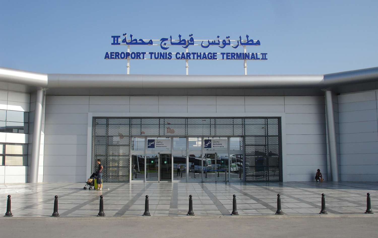
| Terminal 2 |
| IATA: TUN – ICAO: DTTA |
| Summary |
| Airport type |
Public |
| Operator |
Tunisian Civil Aviation & Airports Authority |
| Location |
Tunis, Tunisia |
| Elevation AMSL |
22 ft / 7 m |
| Coordinates |
36°51′04″N 10°13′38″E / 36.85111°N 10.22722°E / 36.85111; 10.22722 |
| Runways |
| Direction |
Length |
Surface |
| m |
ft |
| 01/19 |
3,200 |
10,499 |
Asphalt |
| 11/29 |
2,840 |
9,318 |
Asphalt |
| Source: DAFIF |
Tunis - Carthage International Airport (French: Aéroport international de Tunis-Carthage, Arabic: مطار تونس قرطاج الدولي) (IATA: TUN, ICAO: DTTA) is the international airport serving Tunis in Tunisia.
The airport is named for the historic city of Carthage, located just north of the airport. It is the base of operations for four airlines: Tunisair, Nouvelair Tunisia, Sevenair and Tunisavia. In 2007, it served 3,930,661 passengers.
All ground handling is provided by Tunisair Handling, a 100% subsidiary of Tunisair, and security services are provided by the Police and the Customs.
The airport is served by bus, taxi, but not by railway. Airlines and destinations
The following scheduled passenger airlines use Tunis-Carthage International Airport (as of June 2010):
| Airlines |
Destinations |
| Air Algérie |
Algiers |
| Air Berlin |
Cologne/Bonn |
| Air Europa |
Barcelona, Madrid |
| Air France |
Lyon, Marseille, Nice, Paris-Charles de Gaulle |
| Air Malta |
Malta |
| Alitalia |
Rome-Fiumicino |
| Alitalia operated by Air One |
Milan-Malpensa |
| British Airways |
London-Gatwick |
| Buraq Air |
Benghazi, Tripoli |
| EgyptAir |
Cairo |
| Emirates |
Dubai |
| easyJet |
Geneva, London-Gatwick |
| Jat Airways |
Belgrade |
| Karthago Airlines |
Copenhagen, Stockholm-Arlanda, Tripoli |
| Libyan Airlines |
Benghazi, Misurata, Sebha, Tripoli |
| Lufthansa |
Frankfurt |
| Mauritania Airways |
Nouakchott |
| Qatar Airways |
Doha |
| Royal Air Maroc |
Casablanca |
| Royal Air Maroc Express |
Casablanca |
| Royal Jordanian |
Amman-Queen Alia |
| Saudi Arabian Airlines |
Jeddah |
| Sevenair |
Djerba, Gabès, Gafsa, Malta, Monastir, Naples, Palermo, Tabarka, Tozeur, Tripoli |
| Tunisair |
Abidjan, Algiers, Amman-Queen Alia, Amsterdam, Athens, Bahrain, Bamako, Barcelona, Beirut, Belgrade, Benghazi, Berlin-Schönefeld, Bordeaux, Brussels, Cairo, Casablanca, Dakar, Damascus, Dubai, Düsseldorf, Frankfurt, Geneva, Hamburg, Istanbul-Atatürk, Jeddah, Kuwait, Lisbon, London-Heathrow, Luxembourg, Lyon, Madrid, Malaga, Marseille, Milan-Malpensa, Munich, Nantes, Nice, Nouakchott, Oran, Paris-Orly, Rome-Fiumicino, Strasbourg, Toulouse, Tripoli, Venice-Marco Polo [begins 31 October], Vienna, Zurich |
| Turkish Airlines |
Istanbul-Atatürk |
World War II
 | |
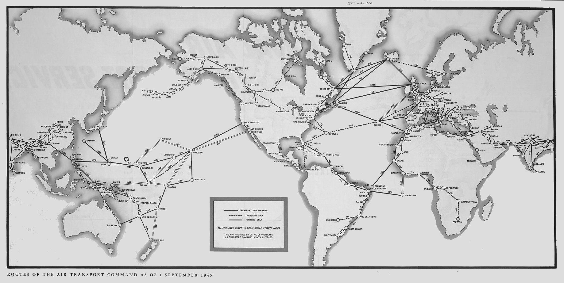
Air Transport Command Routes |
During World War II, the airport was used by the United States Army Air Force Twelfth Air Force during the Italian Campaign in 1943 as a headquarters and command control base. The following known units were assigned:
- HQ, 87th Fighter Group, 22 November-14 December 1943
- 3d Reconnaissance Group, 13 June-8 December 1943, F-4/F-5 Lightning
- 5th Reconnaissance Group, 8 September-8 December 1943, F-4/F-5 Lightning
Once the combat units moved to Italy, Air Transport Command used the airport as a major transshipment hub for cargo, transiting aircraft and personnel. It functioned as a stopover en-route to Algiers airport or to Mellaha Field near Tripoli on the North African Cairo-Dakar transport route, Later, as the Allied forces advanced, it also flew personnel and cargo to Naples, Italy.
Notable incidents
On May 7, 2002, EgyptAir Flight 843, a Boeing 737 from Cairo crashed 4 miles from Tunis-Carthage International Airport. 14 of the 62 people on board were killed.
The above content comes from Wikipedia and is published under free licenses – click here to read more.
| General Info
|
| Country |
Tunisia
|
| ICAO ID |
DTTA
|
| Time |
UTC+1(+2DT)
|
| Latitude |
36.851033
36° 51' 03.72" N
|
| Longitude |
10.227217
010° 13' 37.98" E
|
| Elevation |
22 feet
7 meters
|
| Type |
Civil
|
| Magnetic Variation |
001° E (01/06)
|
| Operating Agency |
CIVIL GOVERNMENT, (LANDING FEES AND DIPLOMATIC CLEARANCE MAY BE REQUIRED)
|
| Near City |
Tunis
|
| Operating Hours |
SEE REMARKS FOR OPERATING HOURS OR COMMUNICATIONS FOR POSSIBLE HOURS
|
| International Clearance Status |
Airport of Entry
|
| Daylight Saving Time |
Dates notified by NOTAM
|
| Communications
|
| TUNIS TWR |
118.1
|
| TUNIS GND |
121.9
|
| TUNIS ATIS |
118.675
|
| TUNIS APP |
121.2
119.5
|
| Runways
|
| ID |
Dimensions |
Surface |
PCN |
ILS
|
| 01/19 |
10480 x 148 feet
3194 x 45 meters |
ASPHALT |
060FBWT |
YES
|
| 11/29 |
9318 x 148 feet
2840 x 45 meters |
ASPHALT |
045FBYU |
YES
|
| Navaids
|
| Type |
ID |
Name |
Channel |
Freq |
Distance From Field |
Bearing From Navaid
|
| VOR-DME |
TUC |
TUNIS |
112X |
116.5 |
At Field |
-
|
| NDB |
TS |
TUNIS |
- |
325 |
5.4 NM |
191.3
|
| Supplies/Equipment
|
| Fuel |
Jet A1, without icing nhibitor.
100/130 MIL Spec, low lead, aviation gasoline (BLUE)
|
| Remarks
|
| CAUTION |
Est WIP til 30 Jun 07. Crane 105' near arpt.
|
| FUEL |
Avbl 0700-1700Z++ A1 (Total Tunisie South Africa (216-171) 8677/9053, fax (216-171)7689). 48 hr PN rqr for aft hr svc. (NC-100LL)
|
| OPR HOURS |
Opr 0700-1600Z Mon-Fri; (0600-1200Z Mon-Fri DT; 0700-1300Z Mon-Fri Ramadan.)
|
The content above was published at Airports-Worldwide.com in 2010.
We don't guarantee the information is fresh and accurate. The data may be wrong or outdated.
For more up-to-date information please refer to other sources.
|
|