 |
|
| Dushanbe Airport |
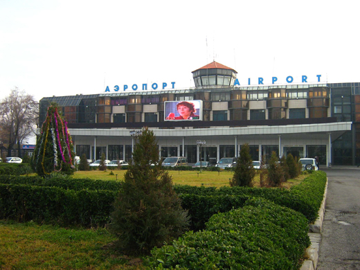 |
| Dushanbe airport in 2007 |
| IATA: DYU – ICAO: UTDD |
| Summary |
| Airport type |
Joint (Civil and Military) |
| Location |
Dushanbe |
| Elevation AMSL |
2,575 ft / 785 m |
| Coordinates |
38°32′36″N 068°49′30″E / 38.54333°N 68.825°E / 38.54333; 68.825Coordinates: 38°32′36″N 068°49′30″E / 38.54333°N 68.825°E / 38.54333; 68.825 |
| Runways |
| Direction |
Length |
Surface |
| ft |
m |
| 09/27 |
10,170 |
3,100 |
Asphalt |
Dushanbe Airport (IATA: DYU, ICAO: UTDD) is an airport located in Dushanbe, the capital of Tajikistan. Work has begun on upgrading facilities at the airport. Funds made available from unnamed sources will finance enhancements to the runway and apron and the upgrade of the terminal buildings (originally built in 1964) to handle modern western aircraft.
Airlines and destinations
| Airlines |
Destinations |
| airBaltic |
Riga |
| Atlant-Soyuz Airlines |
Krasnoyarsk, Moscow-Vnukovo, Samara |
| Avia Traffic Company |
Bishkek |
| China Southern Airlines |
Ürümqi |
| Kam Air |
Kabul |
| Kyrgyzstan Airlines |
Bishkek |
| Iran Aseman Airlines |
Mashhad, Tehran-Imam Khomeini |
| Pamir Airways |
Kabul |
| Rossiya |
St Petersburg |
| S7 Airlines |
Chelyabinsk, Novosibirsk, Perm, St Petersburg |
| SCAT |
Almaty |
| Somon Air |
Dubai, Frankfurt, Istanbul-Atatürk, Khujand, Krasnoyarsk, Moscow-Domodedovo, Orenburg, St Petersburg |
| Tajik Air |
Almaty, Bishkek, Irkutsk, Khorog, Khujand, Moscow-Domodedovo, Nizhnevartovsk, Novosibirsk, St Petersburg, Samara, Sharjah, Sochi, Surgut, Tehran-Imam Khomeini, Yekaterinburg |
| Tatarstan Airlines |
Kazan |
| Turkish Airlines |
Istanbul-Atatürk |
The above content comes from Wikipedia and is published under free licenses – click here to read more.
| General Info
|
| Country |
Tajikistan
|
| ICAO ID |
UTDD
|
| Time |
UTC+5
|
| Latitude |
38.543333
38° 32' 36.00" N
|
| Longitude |
68.825000
068° 49' 30.00" E
|
| Elevation |
2575 feet
785 meters
|
| Type |
Joint (Civil and Military)
|
| Magnetic Variation |
004° E (01/06)
|
| Operating Agency |
MILITARY - CIVIL JOINT USE AIRPORT
|
| Operating Hours |
24 HOUR OPERATIONS
|
| International Clearance Status |
Airport of Entry
|
| Communications
|
| TWR |
119.2
|
| GND |
121.7
|
| ATIS |
126.2
|
| APP |
127.1
|
| Communications Remarks |
|
| ATIS |
(Russian - English)
|
| GND |
(CS Taxiing)
|
| Runways
|
| ID |
Dimensions |
Surface |
PCN |
ILS
|
| 09/27 |
10170 x 147 feet
3100 x 45 meters |
ASPHALT |
072FCWT |
NO
|
| Navaids
|
| Type |
ID |
Name |
Channel |
Freq |
Distance From Field |
Bearing From Navaid
|
| VOR-DME |
DNB |
DUSHANBE |
083X |
113.6 |
At Field |
-
|
| NDB |
WG |
DUSHANBE |
- |
420 |
2.8 NM |
266.2
|
| Supplies/Equipment
|
| Fuel |
Jet A1, without icing nhibitor.
|
| Oil |
O-133, 1010, jet Engine Oil (MIL l 6081)
|
| Other Fluids |
OX, Indicates oxygen servicing when type of servicing is unknown
|
| Remarks
|
| CAUTION |
PAR O/S til 31 Dec 05 est. Rwy 27 ALS O/S til 31 Dec 05 est. Twy 4 clsd for cl 1and 2 acft til 31 Dec 05 est.
|
| FLUID |
OX
|
| FUEL |
Fuel Stock Low - Call Aerocontrol C+42 060 5943176 (TS-1)
|
| OIL |
O-MK8
|
| RSTD |
The first 328' (100m) of Rwy 09-27 unuse for tkof.
|
The content above was published at Airports-Worldwide.com in 2010.
We don't guarantee the information is fresh and accurate. The data may be wrong or outdated.
For more up-to-date information please refer to other sources.
|
|


