|
 |
|
||||
|
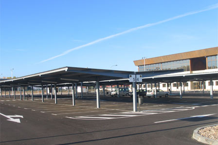
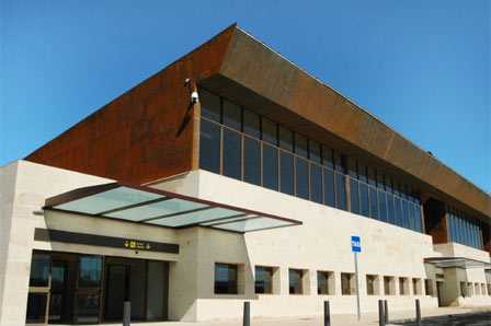
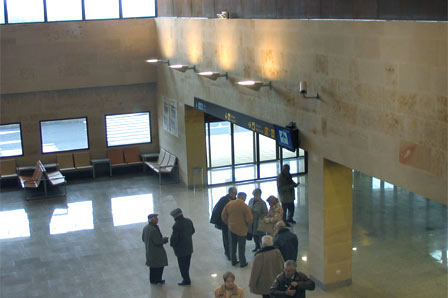
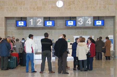
The passenger terminal, inaugurated in 2005, is a two-storey building. The ground floor has a departures area, a check-in area with four desks, a cafeteria and a boarding area, as well as an arrivals area and a baggage reclaim carousel. The second floor houses the secretariat, management and administration offices and the operations room. Salamanca Airport mainly handles domestic flights, although international traffic is expected to increase in coming years. In 2005, the airport handled 23,456 passengers, 8,930 flight operations
and 2.4 tonnes of cargo History The origins of the airport date back to the Civil War, when a new airdrome had to be built in Salamanca. Thus, on 15 October 1936, lieutenant colonel Lecea accompanied the soldier Luis Hernández to visit land located at the spot known as Mata-can, in the town of Encinas de Abajo. The land was considered to be ideal as an airfield. In the summer of 1937, the airline Iberia was reactivated and fixed its base at Salamanca, at the request of General Kindelán. The first route was inaugurated on 16 August with the Tetuán-Vitoria service, using Junkers Ju-52 on loan from Lufthansa. On 1 May 1939, Iberia's equipment and facilities were transferred to Madrid-Barajas. On 16 July 1940, the plenary of Salamanca City Hall ceded the land of Matacán to the Air Force, on the condition that it could also be used for civil air traffic. Six years later, in July 1946, the airport officially opened to domestic and international tourist traffic and technical stopovers for commercial traffic. At the start of 1953, it was decided that a runway be built in the 04/22 direction with a taxiway. On 24 May 1974, the National Aeronautics School (ENA) was set up, with a base in Salamanca. The aim of the centre was to train commercial pilots. In the seventies, the little commercial air traffic Salamanca received was dealt with in the military buildings. In 1990, a new high-precision experimental landing system via MLS microwaves was incorporated. Finally, in october 2005 the new terminal building begins
to work with the arrivals and departures areas, the passengers services
zona and all the airport's facilities. Salamanca Airport - AENA airport Address: URL: http://www.aena.es/salamanca AENA accepts no responsibility for the information posted at this site neither for the possible damages caused for the use of this information. Images and information placed above are from http://www.aena.es/salamanca We thank them for the data!
Runway 03/218202 x 197 feet
|
|||||||||||||||||||||||||||||||||||||||||||||||||||||||||||||||||||||||||||||||||||||||||||||||||||||||||||||||||||||||||||||||||||||||||||||||||||||||||||||||||||||||||||||||||||||||||||||||||||||||||||||||||||||||||||||||||||||||||||||||||||||||||||||||||||||||||||||||||||||||||||||||||||||||||||||||
| Runway 03 | |
|---|---|
| Surface | ASPHALT |
| True Heading | 028.0 |
| Latitude | 40.942025 40° 56' 31.29" N |
| Longitude | -5.509036 005° 30' 32.53" W |
| Elevation | 2595.0
feet 791 meters |
| Slope | -0.1° |
| Landing Distance | 8202
feet 2500 meters |
| Takeoff Distance | 9104
feet 2775 meters |
| Overrun Length | 902
feet 275 meters |
| Overrun Surface | ASPHALT |
| Lighting System | MIRL
REIL A4 PAPI |
| Runway 21 | |
|---|---|
| Surface | ASPHALT |
| True Heading | 208.0 |
| Latitude | 40.962025 40° 57' 43.29" N |
| Longitude | -5.495064 005° 29' 42.23" W |
| Elevation | 2586.0
feet 788 meters |
| Slope | 0.1° |
| Landing Distance | 8202
feet 2500 meters |
| Takeoff Distance | 9104
feet 2775 meters |
| Overrun Length | 902
feet 275 meters |
| Overrun Surface | ASPHALT |
| Lighting System | MIRL
REIL A4 PAPI |
| Runway 08 | |
|---|---|
| Surface | GRADED OR ROLLED EARTH, GRASS ON GRADED EARTH. |
| True Heading | 074.0 |
| Latitude | 40.949794 40° 56' 59.26" N |
| Longitude | -5.512756 005° 30' 45.92" W |
| Elevation | 2587.0
feet 789 meters |
| Slope | 0.0° |
| Landing Distance | 6594
feet 2010 meters |
| Takeoff Distance | 6594
feet 2010 meters |
| Runway 26 | |
|---|---|
| Surface | GRADED OR ROLLED EARTH, GRASS ON GRADED EARTH. |
| True Heading | 254.0 |
| Latitude | 40.954756 40° 57' 17.12" N |
| Longitude | -5.489722 005° 29' 23.00" W |
| Elevation | 2588.0
feet 789 meters |
| Slope | 0.0° |
| Landing Distance | 6594
feet 2010 meters |
| Takeoff Distance | 6594
feet 2010 meters |
| SALAMANCA | |||||
|---|---|---|---|---|---|
| Type | ID | Channel | Freq | Country | State |
| TACAN | TSC | 080X | - | Spain | - |
| Latitude | Longitude | Airport |
| 40.955222 40° 57' 18.80" N |
-5.502481 005° 30' 08.93" W |
LESA |
| SALAMANCA | |||||
|---|---|---|---|---|---|
| Type | ID | Channel | Freq | Country | State |
| VOR-DME | BBI | 059X | 112.2 | Spain | - |
| Latitude | Longitude | Airport |
| 41.016808 41° 01' 00.51" N |
-5.456444 005° 27' 23.20" W |
LESA |
| SALAMANCA | |||||
|---|---|---|---|---|---|
| Type | ID | Channel | Freq | Country | State |
| NDB | SCA | - | 423 | Spain | - |
| Latitude | Longitude | Airport |
| 40.927239 40° 55' 38.06" N |
-5.616594 005° 36' 59.74" W |
LESA |
Salamanca Airport - AENA airport
The content above was published at Airports-Worldwide.com in 2006.
We don't guarantee the information is fresh and accurate. The data may be wrong or outdated.
For more up-to-date information please refer to other sources.

 |
|
Copyright 2004-2026 © by Airports-Worldwide.com, Vyshenskoho st. 36, Lviv 79010, Ukraine Legal Disclaimer |
 Salamanca airport forms part of the Matacan public civilian
air station. It is situated fifteen kilometres to the east of the city,
falling within the municipal districts of Machacon, Calvarrasa de Abajo
and Villagonzalo de Tormes.
Salamanca airport forms part of the Matacan public civilian
air station. It is situated fifteen kilometres to the east of the city,
falling within the municipal districts of Machacon, Calvarrasa de Abajo
and Villagonzalo de Tormes.