|
 |
|
||||
|
To meet the growing passenger demand, the extension of the runway, the extension of the aircraft parking apron and the installation of an ILS/I to improve operability under adverse weather conditions were inaugurated in October 2005. In 2005, the airport handled 80,894 passengers, 5,279 operations and 0,3 tonnes of cargo. History The aerodrome was located one kilometre north of the village of Virgen del Carmen and seven kilometres south of the city of Leon, an area of hard flat land dedicated to pasture, and its navigation aids comprised a marking in the middle of the airfield and a windsock. It had four hangars to house and repair aircraft, as well as fuel, oil, water and telephone services. At that time the station was the headquarters of Number One Squadron's 21st Inspection Unit, within the Northwest Regional Fleet. During the Spanish Civil War, the Leon aerodrome was the headquarters of numerous airborne units and at the end of the conflict it was listed as class A. At that time it had radio and telephone facilities, a radiogoniometer and night lighting. In the 1940s an aviation school was installed in the facilities, where the first pilots graduated at the General Aviation School. When this was closed it was replaced by the Apprentices School and later by the Airforce Specialists School. In 1964 Leon Airport was opened to commercial traffic. It now had an airfield with facilities for landing in two directions. The aeronautical limitations were published in 1967 and remained unmodified until 1988. In 1990, the local and regional governments decided to sponsor an airport infrastructure project that would encourage aeronautical activity in the province. For this purpose, Leon's Provincial Council requested authorisation from the Spanish Ministry of Defence to install civil facilities on the land of the military air station, with permission being granted in 1991. In 1994 the first stage of Leon's civil airport project was drawn up and a runway, a link road and an aircraft parking area were built and inaugurated in 1995. The plans for the second stage of the project were drawn up in 1997 and a terminal and service building were built, the works finishing in January 1999. On 2 June 1999, Leon's civil airport was officially inaugurated, following which Iberia established scheduled flight routes to Madrid and Barcelona. In 2003 a new Rescue and Fire Fighting Services Building
was built, with its corresponding developed and landscaped area, as well
as a technical block and an elevated water tank. In October 2005, the
runway and aircraft parking apron extensions were put into service and
an instrument landing system (ILS/I) was installed. León Airport - AENA airport Address: Ctra. de la Ermita, s/n La Virgen del Camino 24198 León Telephone: 987 877 700 , 987 877 703 AENA accepts no responsibility for the information posted at this site neither for the possible damages caused for the use of this information. Images and information placed above are from http://www.aena.es/leon We thank them for the data!
Runway 05/236890 x 148 feet
|
|||||||||||||||||||||||||||||||||||||||||||||||||||||||||||||||||||||||||||||||||||||||||||||||||||||||||||||||||||||||||||||||||||||||||||||||||||||||||||||||||||||||||||||||||||||||||||||||||||||||||||||||||||||||||||||||||||||||||||||||||||||||
| Runway 05 | |
|---|---|
| Surface | ASPHALT |
| True Heading | 045.0 |
| Latitude | 42.581950 42° 34' 55.02" N |
| Longitude | -5.665275 005° 39' 54.99" W |
| Elevation | 2994.0
feet 913 meters |
| Slope | 0.1° |
| Landing Distance | 6890
feet 2100 meters |
| Takeoff Distance | 6890
feet 2100 meters |
| Lighting System | CL
MIRL REIL PAPI |
| Runway 23 | |
|---|---|
| Surface | ASPHALT |
| True Heading | 225.0 |
| Latitude | 42.595236 42° 35' 42.85" N |
| Longitude | -5.647081 005° 38' 49.49" W |
| Elevation | 3001.0
feet 915 meters |
| Slope | -0.1° |
| Landing Distance | 6890
feet 2100 meters |
| Takeoff Distance | 6890
feet 2100 meters |
| Lighting System | CL
MIRL REIL S PAPI |
| Runway 06 | |
|---|---|
| Surface | GRADED OR ROLLED EARTH, GRASS ON GRADED EARTH. |
| True Heading | 060.0 |
| Latitude | 42.589944 42° 35' 23.80" N |
| Longitude | -5.661889 005° 39' 42.80" W |
| Landing Distance | 3609
feet 1100 meters |
| Takeoff Distance | 3609
feet 1100 meters |
| Runway 24 | |
|---|---|
| Surface | GRADED OR ROLLED EARTH, GRASS ON GRADED EARTH. |
| True Heading | 240.0 |
| Latitude | 42.594917 42° 35' 41.70" N |
| Longitude | -5.650306 005° 39' 01.10" W |
| Landing Distance | 3609
feet 1100 meters |
| Takeoff Distance | 3609
feet 1100 meters |
| LEON | |||||
|---|---|---|---|---|---|
| Type | ID | Channel | Freq | Country | State |
| VOR-DME | EON | 057X | 112 | Spain | - |
| Latitude | Longitude | Airport |
| 42.593769 42° 35' 37.57" N |
-5.646144 005° 38' 46.12" W |
LELN |
| LEON | |||||
|---|---|---|---|---|---|
| Type | ID | Channel | Freq | Country | State |
| NDB | LEN | - | 330 | Spain | - |
| Latitude | Longitude | Airport |
| 42.586611 42° 35' 11.80" N |
-5.648056 005° 38' 53.00" W |
LELN |
León Airport - AENA airport
The content above was published at Airports-Worldwide.com in 2006.
We don't guarantee the information is fresh and accurate. The data may be wrong or outdated.
For more up-to-date information please refer to other sources.

 |
|
Copyright 2004-2026 © by Airports-Worldwide.com, Vyshenskoho st. 36, Lviv 79010, Ukraine Legal Disclaimer |
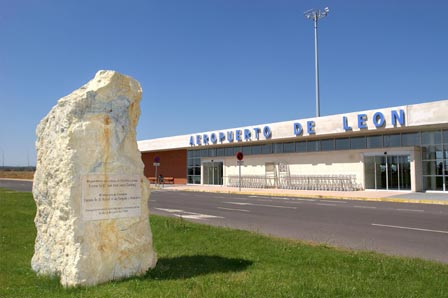
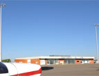 León
Airport opened in June 1999. It is located on the Virgen del
Camino air station, six kilometres from the provincial capital. Currently,
it is an aerodrome used jointly as a military base and an airport open
to civil traffic.
León
Airport opened in June 1999. It is located on the Virgen del
Camino air station, six kilometres from the provincial capital. Currently,
it is an aerodrome used jointly as a military base and an airport open
to civil traffic.