 |
 |
|
||||
|
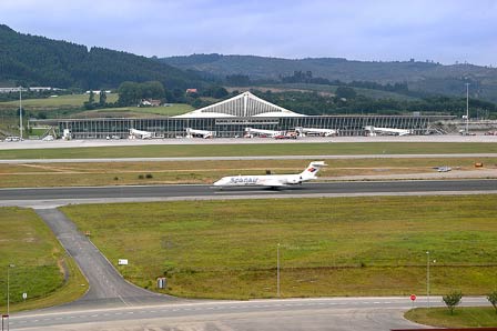
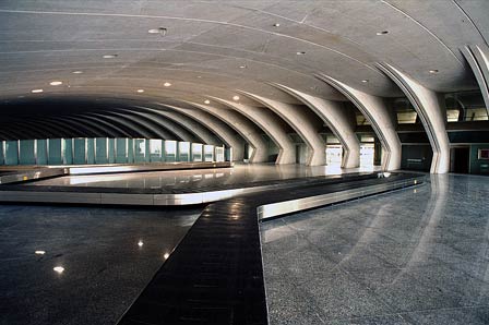
The Airport can be found just 12 kms outside the City of Bilbao and in the last 10 years the passenger traffic has more than doubled from 1.6 million passengers in 1995 to just under 3.4 million passengers in 2004. In Spanish it is known as Aeropuerto de Bilbao. The baggage area at Bilbao Airport is in a bright room on the ground floor of the terminal. After collecting your luggage head for the main Bilbao Airport arrivals hall where you will find directions for the buses and taxis. You will also find a selection of Car Hire companies and tourist information offices within the hall. On the top floor of the terminal you will find the Bilbao Airport departures hall which has 36 check in desks and is accessed by crossing a five lane (38m) bridge. After checking in the departures lounge has a Duty Free shop and a couple of other gift shops and cafes. Leave plenty of time for the walk to your aircraft as you will pass along a 300m glass sided corrider that gives you a fantastic view of the entire airport terminal. Iberia have a VIP lounge on the 1st Floor of the departure hall and you can call them on 0034 944 869 836. Spanair also have a VIP lounge but on the second floor, 0034 944 869 777. The Bilbao Airport buses start the service into the City Center at 0615 each morning and run every 30 minutes until midnight. The fares for the 15 minute journey are €1.15. Bilbao Airport taxis can be found outside the main arrivals hall and the fare for the journey into Bilbao City center is around €20. History The construction works commenced during the Civil War but during this time and until June 1937 the airport was only used as a base for military activities. In 1938, the second stage of the airport's development began. The council resumed procedures with the government to modify the primitive project of 1936 and the drafting of a new project was authorised and later approved by the General Management of Infrastructure. The airport opens to traffic In 1940, it was decided by common agreement with the local organisations affected to build a civilian airport in Sondika. The construction works progressed slowly and on the 19th September 1948, the airport was at last opened to daytime traffic with the establishment of an air path to Madrid by Aviación y Comercio, SA. Two years later, the terminal, named Carlos Haya after the well-known pilot from Bilbao, began to give service. At this time, the airport had an asphalt runway, the 11-29 (measuring 1,440 by 45 metres), another earth runway (measuring 1,500 by 150 metres), a taxiway, a passenger terminal, a tower control, a radio beacon, a direction finder as well as police, post office, weather, health, fuel and telephone services. In 1955, a taxiway was built to link the runway with the parking stands and terminal. An apron measuring 124 by 60 metres, a hangar for the Royal Flying Club of Vizcaya and permanent facilities for Campsa were also built. Between 1964 and 1965, an instrumental ILS landing system and a meteorological radio for storm detection were installed; the runway was extended to 2,000 metres and the apron to 12,000 square metres. In 1975, the runway was surfaced and its orientation became 10-28 due to the change in magnetic declination. In 1977, the parking stand was extended, a link road was built and an ILS system was installed. The runway 12-30, measuring 2,600 metres long, was opened the same year and the airport was classified as first category the following year. During the eighties, the ILS landing system entered into service for runway 10/30; the communication centre, passenger terminal and parking facilities were enlarged; and a fire service building and cargo terminal were constructed. In 1996, a new taxiway with two rapid exits and a new
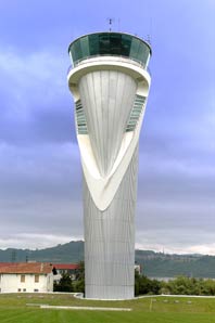
aircraft parking apron were built. In May 1999, the new tower control
was put into service, which allowed for a more centred vision of the airfield
and at the same time facilitated airport operations. On the 19th November
2000, a new terminal area was opened in the north zone. This was comprised
of a new terminal building, with a surface area of 32,000 square metres,
a car park with 3,000 parking spaces measuring 95,000 square metres and
a north apron for aircraft parking to serve the new terminal area Address: Airport Code: BIO Telephone: 0034 944 869 664 E-mail: infobio at aena es URL: http://www.aena.es/bilbao
AENA accepts no responsibility for the information posted at this site neither for the possible damages caused for the use of this information. Images and information placed above are from Text from Wikipedia is available under the Creative Commons Attribution/Share-Alike License; additional terms may apply.
Runway 10/286562 x
148 feet
|
|||||||||||||||||||||||||||||||||||||||||||||||||||||||||||||||||||||||||||||||||||||||||||||||||||||||||||||||||||||||||||||||||||||||||||||||||||||||||||||||||||||||||||||||||||||||||||||||||||||||||||||||||||||||||||||||||||||||||
| Runway 10 | |
|---|---|
| Surface | ASPHALT |
| True Heading | 097.0 |
| Latitude | 43.303347 43° 18' 12.05" N |
| Longitude | -2.937025 002° 56' 13.29" W |
| Elevation | 116.0
feet 35 meters |
| Slope | 0.2° |
| Landing Distance | 6562
feet 2000 meters |
| Takeoff Distance | 6562
feet 2000 meters |
| Lighting System | HIRL
S PAPI |
| Runway 28 | |
|---|---|
| Surface | ASPHALT |
| True Heading | 277.0 |
| Latitude | 43.301264 43° 18' 04.55" N |
| Longitude | -2.912539 002° 54' 45.14" W |
| Elevation | 129.0
feet 39 meters |
| Slope | -0.2° |
| Landing Distance | 6562
feet 2000 meters |
| Takeoff Distance | 6562
feet 2000 meters |
| Lighting System | HIRL
PAPI |
| Runway 12 | |
|---|---|
| Surface | ASPHALT |
| True Heading | 117.0 |
| Latitude | 43.306347 43° 18' 22.85" N |
| Longitude | -2.924936 002° 55' 29.77" W |
| Elevation | 119.0
feet 36 meters |
| Slope | 0.0° |
| Landing Distance | 8530
feet 2600 meters |
| Takeoff Distance | 8530
feet 2600 meters |
| Lighting System | CL
HIRL A2 PAPI |
| Runway 30 | |
|---|---|
| Surface | ASPHALT |
| True Heading | 297.0 |
| Latitude | 43.295850 43° 17' 45.06" N |
| Longitude | -2.896297 002° 53' 46.67" W |
| Elevation | 120.0
feet 37 meters |
| Slope | 0.0° |
| Landing Distance | 7021
feet 2140 meters |
| Takeoff Distance | 8530
feet 2600 meters |
| Displaced Threshold Length | 1509
feet 460 meters |
| Lighting System | TDZL
CL HIRL BS PAPI |
| BILBAO | |||||
|---|---|---|---|---|---|
| Type | ID | Channel | Freq | Country | State |
| VOR-DME | BLV | 106X | 115.9 | Spain | - |
| Latitude | Longitude | Airport |
| 43.304381 43° 18' 15.77" N |
-2.935878 002° 56' 09.16" W |
LEBB |
Bilbao Airport - AENA airport
The content above was published at Airports-Worldwide.com in 2006.
We don't guarantee the information is fresh and accurate. The data may be wrong or outdated.
For more up-to-date information please refer to other sources.

 |
|
Copyright 2004-2026 © by Airports-Worldwide.com, Vyshenskoho st. 36, Lviv 79010, Ukraine Legal Disclaimer |
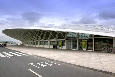
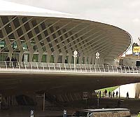 The Airport at Bilbao was designed by
the famous Architect Santiago Calatrava and is a reflection of the modernization
of this buzzing, Spanish City that is also home to the Guggenhaim Museum.
The Airport at Bilbao was designed by
the famous Architect Santiago Calatrava and is a reflection of the modernization
of this buzzing, Spanish City that is also home to the Guggenhaim Museum.
 Bilbao Airport - AENA airport