|
Trstenik Airport (ICAO: LYTR) (Serbian: Аеродром Трстеник, Latin: Aerodrom Trstenik) also known as “Ozai” is an airport inSerbia, 2.5 km from the town of Trstenik and 12 km from the spa of Vrnjačka Banja. The airport is within the closest vicinity (60 kilometers-about 50 minutes by Bus, instead 2 hours 45 mins from Niš Constantine the Great Airport transfer) to the famous Kopaonikmountain ski resort, and is also 20 kilometers from the Goč mountain.
The Grass runway is 80 meters (262 feet) wide with Concrete runway beginnings on both thresholds are 30 meters (98 feet) in width and 300 meters (985 feet) in length.
In 1990, construction work came to a finish on the building of both a new control tower and underground fuel tanks.
Trstenik Airport
Аеродром Трстеник
Aerodrom Trstenik |
| IATA: none – ICAO: LYTR
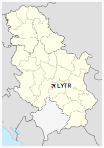
Location of the airport in Serbia |
| Summary |
| Airport type |
Public |
| Operator |
Civil Government |
| Location |
Trstenik |
| Elevation AMSL |
525 ft / 160 m |
| Coordinates |
43°36′51.08″N
021°01′48.78″E |
| Runways |
| Direction |
Length |
Surface |
| ft |
m |
| 11/29 |
6,234 |
1,900 |
Concrete/Grass |
History
On July 4, 1965, the Jat Airways, then known as JAT Yugoslav Airlines, opened line between Belgrade and spa resort Vrnjačka Banjawith a Convair CV-440 Metropolitan airliner.
In 2007 the Vrnjačka Banja resort and the Trstenik airport requested approval for opening the airport to the public. The government will most likely accept the proposal.
The above content comes from Wikipedia and is published under free licenses – click here to read more.
The content above was published at Airports-Worldwide.com in 2014.
We don't guarantee the information is fresh and accurate. The data may be wrong or outdated.
For more up-to-date information please refer to other sources.
|