|
|
Mirny Airport
Аэропорт Мирный |
 |
| IATA: MJZ – ICAO: UERR |
| Summary |
| Airport type |
Public |
| Operator |
Alrosa Mirny Air Enterprise |
| Serves |
Mirny, Russia |
| Location |
Yakutia, Russia |
| Elevation AMSL |
1155 ft / 352 m |
| Coordinates |
62°32′04″N 114°02′20″E / 62.53444°N 114.03889°E / 62.53444; 114.03889Coordinates: 62°32′04″N 114°02′20″E / 62.53444°N 114.03889°E / 62.53444; 114.03889 |
| Runways |
| Direction |
Length |
Surface |
| ft |
m |
| 06/24 |
9,187 |
2,800 |
Concrete |
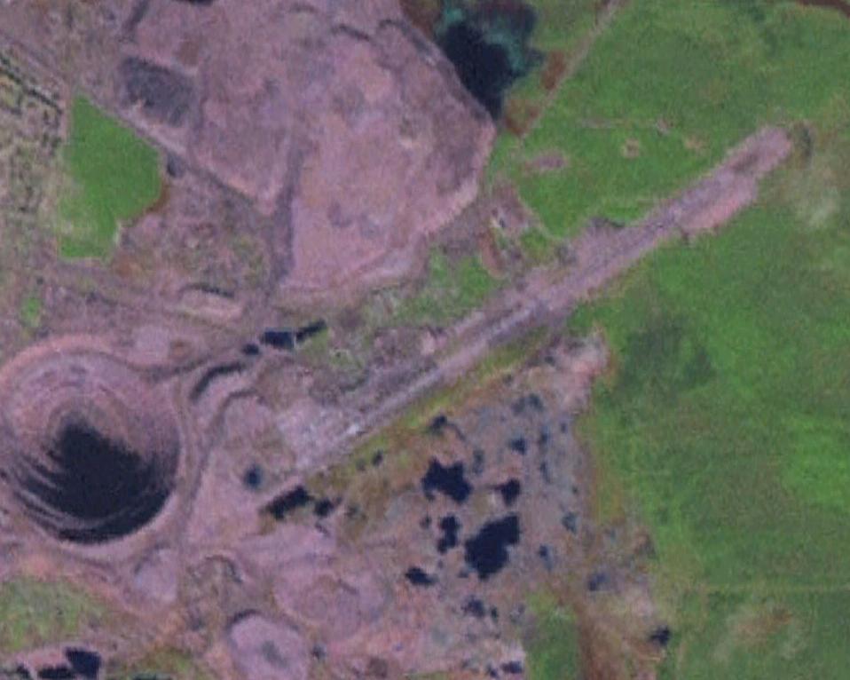
Mirny Airport (Russian: Аэропорт Мирный) (IATA: MJZ, ICAO: UERR) is an airport in Yakutia, Russia, located 4 km east of the mining town of Mirny. It handles medium-sized airliners and supports 24-hour flight operations. Mirny is a designated emergency airfield for the polar route between North America and Asia. The airport is home base for Alrosa Mirny Air Enterprise. Airlines and destinations
| Airlines |
Destinations |
| Alrosa Mirny Air Enterprise |
Aykhal, Irkutsk, Krasnodar, Krasnoyarsk, Lensk, Moscow-Domodedovo, Moscow-Vnukovo, Novosibirsk, Olenyok, Polyarny, Saskylakh, Yakutsk |
| Yakutia Airlines |
Yakutsk |
Incidents and accidents
- On November 1, 2009, an Ilyushin Il-76 of the Russian Ministry of Internal Affairs crashed soon after take-off from Mirny airport killing all 11 people on board. The plane was not carrying any cargo loads, as it was a repositioning flight to Irkutsk Airport. The Il-76 banked to the right and crashed into the ground near an old diamond mine.
The above content comes from Wikipedia and is published under free licenses – click here to read more.
| General Info
|
| Country |
Russia
|
| ICAO ID |
UERR
|
| Time |
UTC+9(+10DT)
|
| Latitude |
62.534689
62° 32' 04.88" N
|
| Longitude |
114.038928
114° 02' 20.14" E
|
| Elevation |
1156 feet
352 meters
|
| Type |
Civil
|
| Magnetic Variation |
010° W (01/06)
|
| Operating Agency |
CIVIL GOVERNMENT, (LANDING FEES AND DIPLOMATIC CLEARANCE MAY BE REQUIRED)
|
| Operating Hours |
24 HOUR OPERATIONS
|
| Daylight Saving Time |
Last Sunday in March to last Sunday in October
|
| Communications
|
LANDING
Call START.
|
120.8
|
| ATIS |
126.6
|
APP
Also svc as KRUG and TAXIING.
|
125.9
|
| Runways
|
| ID |
Dimensions |
Surface |
PCN |
ILS
|
| 06/24 |
9187 x 148 feet
2800 x 45 meters |
CONCRETE. |
045RAWT |
YES
|
| Navaids
|
| Type |
ID |
Name |
Channel |
Freq |
Distance From Field |
Bearing From Navaid
|
| VOR-DME |
DEM |
MIRNY |
085X |
113.8 |
At Field |
-
|
| NDB |
SG |
MIRNY |
- |
385 |
2.8 NM |
234.8
|
| Remarks
|
| MISC |
Arpt for emerg ldg of flt opr along the cros-polar rte.
|
| RSTD |
First 328' of Rwy 06-24 unuse for tkof.
|
The content above was published at Airports-Worldwide.com in 2010.
We don't guarantee the information is fresh and accurate. The data may be wrong or outdated.
For more up-to-date information please refer to other sources.
|
|