 |
|
Koltsovo Airport
Аэропорт Кольцово |
 |
| IATA: SVX – ICAO: USSS |
| Summary |
| Airport type |
Public |
| Operator |
Koltsovo International Airport |
| Location |
Yekaterinburg |
| Elevation AMSL |
764 ft / 233 m |
| Coordinates |
56°44′29″N 60°48′13″E / 56.74139°N 60.80361°E / 56.74139; 60.80361Coordinates: 56°44′29″N 60°48′13″E / 56.74139°N 60.80361°E / 56.74139; 60.80361 |
| Website |
http://www.koltsovo.ru/ |
| Runways |
| Direction |
Length |
Surface |
| ft |
m |
| 08R/26L |
9,925 |
3,025 |
Concrete |
| 08L/26R |
8,192 |
2,497 |
Asphalt |
Koltsovo Airport (Russian: Аэропорт Кольцово) (IATA: SVX, ICAO: USSS) is an international airport located 16 km (10 mi) southeast of Yekaterinburg, Russia. The airport is a hub for Ural Airlines and Aviacon Zitotrans.
The airport was opened in 1928 as a military airbase and became a civilian airport on July 10, 1943. In October 1993 it acquired international status.
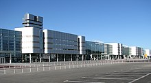 | |
Terminals A and B |
As of 2005, Koltsovo is the fifth largest airport in Russia and a member of Airports Council International (ACI). In 2006, it handled 1,764,948 passengers and 15,519 metric tonnes of cargo. In 2007, it handled 2,345,097 passengers, representing a 32.9% increase compared to the previous year. The airport has sixty aircraft stands and serves more than 50 destinations worldwide including a dozen in Europe.
The new international terminal opened in December 2005, and the new domestic terminal in October 2007[1]. A new logistics center and a large cargo terminal are currently under construction. A third runway has been constructed in June 2009, enabling the airport to handle all types of heavy aircraft, including the Boeing 747 and Airbus A380. Koltsovo Airport is also officially able to handle Airbus A320, Boeing 737, Boeing 747, and Airbus A330. The new air traffic control tower was also completed in June.
Airlines and destinations
| Airlines |
Destinations |
| Aeroflot |
Moscow-Sheremetyevo |
| Air China |
Beijing-Capital [ends 29 October] |
| Air Volga |
Novyi Urengoy, Nadym, Salekhard, Surgut, Tomsk, Volgograd |
| Alrosa Mirny Air Enterprise |
Mirny, Novosibirsk |
| Armavia |
Yerevan |
| Avianova |
Moscow-Sheremetyevo |
| Belavia |
Minsk |
| Czech Airlines |
Prague |
| Donavia |
Rostov-on-Don |
| Finnair |
Helsinki |
| Flydubai |
Dubai [begins 16 October] |
| Izhavia |
Izhevsk |
| Lufthansa |
Frankfurt |
| Nordavia |
Moscow-Sheremetyevo |
| Rossiya |
St Petersburg |
| S7 Airlines |
Moscow-Domodedovo |
| Sky Express |
Moscow-Vnukovo |
| Tajik Air |
Dushanbe, Khudzand, Kurgan-Tube |
| Transaero Airlines |
Bangkok-Suvarnbabhumi [seasonal], Hurghada [seasonal], Moscow-Domodedovo, Phuket [seasonal], Sharm el-Sheikh [seasonal] |
| Turan Air |
Baku |
| Turkish Airlines |
Istanbul-Atatürk, Antalya [seasonal] |
| UTair Aviation |
Beloyarkyi, Khanty-Mansiysk, Irkutsk, Makhachkala, Nizhnevartovsk, Nizhny Novgorod, Novosibirsk, Surgut |
| Ural Airlines |
Almaty, Antalya, Bangkok-Suvarnbabhumi [seasonal], Baku, Barcelona, Beijing-Capital, Bourgas [seasonal], Dubai, Ganja, Heraklion [seasonal], Irkutsk, Larnaca [seasonal], Khabarovsk, Krasnodar, Krasnoyarsk, Moscow-Domodedovo, Moscow-Sheremetyevo, Namangan, Novosibirsk, Prague, Pula [seasonal], Rome-Fiumicino, St Petersburg, Salekhard, Samara, Simferopol, Sochi, Sofia, Tel Aviv, Thessaloniki [seasonal], Tivat [seasonal], Varna [seasonal], Vienna, Vladivostok, Yerevan |
| Uzbekistan Airways |
Taskhent |
| Vladivostok Air |
Khabarovsk, Krasnodar, Krasnoyarsk, Moscow-Vnukovo, Tianjin [charter], Vladivostok |
| Yamal Airlines |
Salekhard |
The above content comes from Wikipedia and is published under free licenses – click here to read more.
| General Info
|
| Country |
Russia
|
| ICAO ID |
USSS
|
| Time |
UTC+5(+6DT)
|
| Latitude |
56.743108
56° 44' 35.19" N
|
| Longitude |
60.802728
060° 48' 09.82" E
|
| Elevation |
764 feet
233 meters
|
| Type |
Civil
|
| Magnetic Variation |
014° E (01/06)
|
| Operating Agency |
CIVIL GOVERNMENT, (LANDING FEES AND DIPLOMATIC CLEARANCE MAY BE REQUIRED)
|
| Near City |
Yekaterinburg
|
| Operating Hours |
24 HOUR OPERATIONS
|
| Daylight Saving Time |
Last Sunday in March to last Sunday in October
|
| Communications
|
| TWR |
120.0
|
| GND |
119.0
|
| ATIS |
127.8
|
| RADAR |
118.7
|
| APP |
125.9
|
| Runways
|
| ID |
Dimensions |
Surface |
PCN |
ILS
|
| 08R/26L |
9925 x 174 feet
3025 x 53 meters |
CONCRETE. |
046RBWT |
YES
|
| 08L/26R |
8192 x 148 feet
2497 x 45 meters |
ASPHALT |
062FDWT |
YES
|
| Navaids
|
| Type |
ID |
Name |
Channel |
Freq |
Distance From Field |
Bearing From Navaid
|
| NDB |
KU |
YEKATERINBURG |
- |
370 |
2.9 NM |
267.8
|
| Remarks
|
| RSTD |
Rwy 08L-26R avbl daylt only. First 246' of Rwy 08R unuse for tkof.
|
The content above was published at Airports-Worldwide.com in 2010.
We don't guarantee the information is fresh and accurate. The data may be wrong or outdated.
For more up-to-date information please refer to other sources.
|
|


