|
|
Volgograd International Airport
Международный Аэропорт Волгоград |
 |
| IATA: VOG – ICAO: URWW |
| Summary |
| Airport type |
Public |
| Operator |
JSC "Volgograd International Airport" |
| Location |
Volgograd |
| Elevation AMSL |
482 ft / 147 m |
| Coordinates |
48°46′54″N 044°20′48″E / 48.78167°N 44.34667°E / 48.78167; 44.34667Coordinates: 48°46′54″N 044°20′48″E / 48.78167°N 44.34667°E / 48.78167; 44.34667 |
| Runways |
| Direction |
Length |
Surface |
| ft |
m |
| 11/29 |
8,202 |
2,500 |
Asphalt |
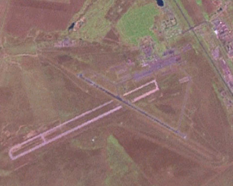
Volgograd International Airport (Russian: Международный Аэропорт Волгоград) (IATA: VOG, ICAO: URWW) is an airport in Russia located 15 km northwest of Volgograd. It comprises a civilian airport built on top of an older military runway (3300 m), now demolished. The terminal area parks 42 medium/large aircraft and 91 small aircraft.
A military training unit was present at Gumrak as late as 1994, the 706 UAP (706th Aviation Training Regiment), using Aero L-39 aircraft. Today, the airport is the home base of Air Volga. Battle of Stalingrad
The airport, then named Gumrak Airport, was used by the German 6th Army as fuel and supply depot (alongside with Pitomnik Airfield) during the Battle of Stalingrad in 1942/43. After the fall of Pitomnik on 17 January 1943, Gumrak was the only one of seven airfields around Stalingrad still in German hands. On 22 January, a last He 111 aircraft left the airfield with 19 wounded soldiers, the last flight out of Stalingrad for the 6th Army. Gumrak eventually fell on 23 January, leaving the 6th Army without any means of direct support.
Airlines and destinations
| Airlines |
Destinations |
| Aeroflot |
Moscow-Sheremetyevo |
| Air Volga |
Moscow-Domodedovo, St Petersburg, Surgut, Yekaterinburg, Yerevan |
| Avianova |
Moscow-Sheremetyevo |
| Donavia |
Moscow-Sheremetyevo |
| Kogalymavia |
Surgut |
| UTair |
Moscow-Vnukovo |
| S7 Airlines |
Moscow-Domodedovo |
| Rossiya |
Saint Petersburg |
The above content comes from Wikipedia and is published under free licenses – click here to read more.
| General Info
|
| Country |
Russia
|
| ICAO ID |
URWW
|
| Time |
UTC+3(+4DT)
|
| Latitude |
48.782528
48° 46' 57.10" N
|
| Longitude |
44.345544
044° 20' 43.96" E
|
| Elevation |
482 feet
147 meters
|
| Type |
Civil
|
| Magnetic Variation |
008° E (01/06)
|
| Operating Agency |
CIVIL GOVERNMENT, (LANDING FEES AND DIPLOMATIC CLEARANCE MAY BE REQUIRED)
|
| Near City |
Volgograd
|
| Operating Hours |
24 HOUR OPERATIONS
|
| Daylight Saving Time |
Last Sunday in March to last Sunday in October
|
| Communications
|
VOLGOGRAD TWR
Call START.
|
128.0
|
| VOLGOGRAD TAXIING |
119.0
|
| VOLGOGRAD ATIS |
132.8
|
| VOLGOGRAD KRUG |
122.0
|
| VOLGOGRAD APP |
125.3
129.0
|
| Runways
|
| ID |
Dimensions |
Surface |
PCN |
ILS
|
| 08/26 |
1595 x 350 feet
486 x 107 meters |
GRASS OR EARTH NOT GRADED OR ROLLED. |
- |
NO
|
| 11/29 |
8202 x 161 feet
2500 x 49 meters |
ASPHALT |
044FDXT |
YES
|
| 11R/29L |
5575 x 330 feet
1699 x 101 meters |
GRASS OR EARTH NOT GRADED OR ROLLED. |
- |
NO
|
| Navaids
|
| Type |
ID |
Name |
Channel |
Freq |
Distance From Field |
Bearing From Navaid
|
| NDB |
WG |
VOLGOGRAD |
- |
325 |
2.7 NM |
120.0
|
The content above was published at Airports-Worldwide.com in 2010.
We don't guarantee the information is fresh and accurate. The data may be wrong or outdated.
For more up-to-date information please refer to other sources.
|
|