 |
|
Padre Aldamiz International Airport
Puerto Maldonado International Airport |
 |
| IATA: PEM – ICAO: SPTU |
| Summary |
| Airport type |
Military/Public |
| Operator |
CORPAC S.A. |
| Location |
Puerto Maldonado |
| Elevation AMSL |
659 ft / 201 m |
| Coordinates |
12°36′49″S 069°13′43″W / 12.61361°S 69.22861°W / -12.61361; -69.22861Coordinates: 12°36′49″S 069°13′43″W / 12.61361°S 69.22861°W / -12.61361; -69.22861 |
| Runways |
| Direction |
Length |
Surface |
| ft |
m |
| 01/19 |
11,482 |
3,500 |
Concrete |
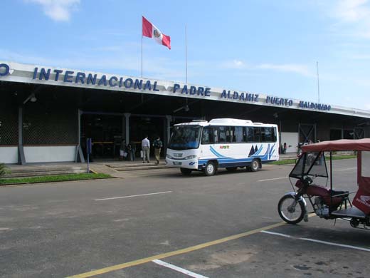
Padre Aldamiz International Airport (IATA: PEM, ICAO: SPTU), also known as Puerto Maldonado International Airport, is a small airport located in the Peruvian city of Puerto Maldonado in the Madre de Dios Region. The airport oversees a small number of international commercial flights.
Padre Aldamiz International Airport is located near some of Peru's noted ecological areas, such as the national jungle reserve of Tambopata-Candamo. Much like many small airports around the world, Padre Aldamiz International Airport benefits mostly from one type of traveler, in this case ecology tourists. Western doctors often warn that airport authorities require travelers to carry documentation informing about yellow fever vaccination because of its rainforest location.
The airport was served by Peru's national airline, AeroPerú. AeroPerú ceased operations in the 1990s, and, subsequently, other airlines have entered the Lima to Puerto Maldonado air route. Nuevo Continente made an attempt during the 2000s, but that airline suspended operations amid allegations of drug trafficking by their owners. It is currently served by both LAN Perú and Star Perú.
The Peruvian Air Force flies Boeing 707 jets to Padre Aldamiz International Airport, to carry civilian cargo operations. The airport can handle landings by different types of jets. For example, LAN Perú uses Airbus A320 family aircraft.
Airlines and destinations
| Airlines |
Destinations |
| LAN Perú |
Cusco, Lima |
| Star Perú |
Cusco, Lima |
The above content comes from Wikipedia and is published under free licenses – click here to read more.
| General Info
|
| Country |
Peru
|
| ICAO ID |
SPTU
|
| Time |
UTC-5
|
| Latitude |
-12.613611
12° 36' 49.00" S
|
| Longitude |
-69.228611
069° 13' 43.00" W
|
| Elevation |
659 feet
201 meters
|
| Type |
Joint (Civil and Military)
|
| Magnetic Variation |
006° W (02/06)
|
| Operating Agency |
MILITARY - CIVIL JOINT USE AIRPORT
|
| Near City |
Puerto Maldonado
|
| Communications
|
| PUERTO MALDONADO TWR |
118.8
|
| PUERTO MALDONADO RDO |
126.9
|
| PUERTO MALDONADO APP |
118.8
|
| Runways
|
| ID |
Dimensions |
Surface |
PCN |
ILS
|
| 01/19 |
11482 x 148 feet
3500 x 45 meters |
CONCRETE. |
069RCXT |
YES
|
| Navaids
|
| Type |
ID |
Name |
Channel |
Freq |
Distance From Field |
Bearing From Navaid
|
| VOR-DME |
PDO |
PUERTO MALDONADO |
108X |
116.1 |
At Field |
-
|
| Supplies/Equipment
|
| Fuel |
Jet A1, without icing nhibitor.
|
| Remarks
|
| CAUTION |
Taxi fr E side trml ramp with min pwr. Bird haz.
|
| FUEL |
(NC-A1)
|
| OPR HOURS |
Opr 1100-2300Z, OT O/R.
|
The content above was published at Airports-Worldwide.com in 2010.
We don't guarantee the information is fresh and accurate. The data may be wrong or outdated.
For more up-to-date information please refer to other sources.
|
|


