 |
 |
|
||||
|
Together with your support we can ensure Rotorua gets the future it deserves." Graham Hall - Mayor of Rotorua As of the 1st October 2002, all passengers departing Rotorua Airport will be required to pay a development levy of $5, which goes towards enhancing the Airport services and capability. Operator: Rotorua Regional Airport Ltd Address: PO Box 7221 Te Ngae New Zealand Phone: (07) 345 3967 Fax: (07) 345 5466 E-mail:
-
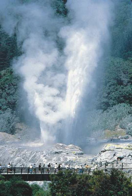
Reminders of Rotorua�s volcanic history are everywhere. You�ll see clouds of steam magically appear around the city - giving it an incredible �other worldly� feel. Rotorua�s 4 major thermal areas are Whakarewarewa, Waimangu, Waiotapu and Hell�s Gate. The village of Whakarewarewa is one of Rotorua�s most active thermal areas. That is where you�ll find the lively Pohutu geyser, which erupts about 20 times a day and can spout up to 100 feet. Other attractions at �Whaka� include hot mud pools, hot springs, and a Maori pa. Aerial & Volcano tours, 4 Wheel Drive safaris, horse riding expeditions, mountain biking and jet boating are all just some of the options Rotorua has to offer.
Rotorua is a Certificated Aerodrome 4NM NE of Rotorua at an elevation of 935 feet.
Images and information placed above are from www.rotoruanz.com/rotoruaairport We thank www.airportsnewzealand.com for the data.
Runway 18R/36L 5124 x 98 feet
|
|||||||||||||||||||||||||||||||||||||||||||||||||||||||||||||||||||||||||||||||||||||||||||||||||||||||||||||||||||||||||||||||||||||||||||||||||||||||||||||||||||||||||||||||||||||||||||||||||||||||||||||||||||||||||||||||||||||||||||||||||||||||||||||||||
| Runway 18R | |
|---|---|
| Surface | ASPHALT |
| True Heading | 205.0 |
| Latitude | -38.100417 38° 06' 01.50" S |
| Longitude | 176.320306 176° 19' 13.10" E |
| Elevation | 935.0 feet 285 meters |
| Slope | 0.0° |
| Landing Distance | 5124 feet 1562 meters |
| Takeoff Distance | 5124 feet 1562 meters |
| Lighting System | LIRL
PAPI |
| Runway 36L | |
|---|---|
| Surface | ASPHALT |
| True Heading | 025.0 |
| Latitude | -38.113167 38° 06' 47.40" S |
| Longitude | 176.312778 176° 18' 46.00" E |
| Elevation | 935.0 feet 285 meters |
| Slope | 0.0° |
| Landing Distance | 5124 feet 1562 meters |
| Takeoff Distance | 5124 feet 1562 meters |
| Lighting System | LIRL
PAPI |
| Runway 18L | |
|---|---|
| Surface | GRASS OR EARTH NOT GRADED OR ROLLED. |
| True Heading | 206.0 |
| Latitude | -38.101667 38° 06' 06.00" S |
| Longitude | 176.320556 176° 19' 14.00" E |
| Landing Distance | 1698 feet 518 meters |
| Takeoff Distance | 2708 feet 825 meters |
| Displaced Threshold Length | 1010 feet 308 meters |
| Runway 36R | |
|---|---|
| Surface | GRASS OR EARTH NOT GRADED OR ROLLED. |
| True Heading | 026.0 |
| Latitude | -38.108333 38° 06' 30.00" S |
| Longitude | 176.316389 176° 18' 59.00" E |
| Landing Distance | 2708 feet 825 meters |
| Takeoff Distance | 2708 feet 825 meters |
| ROTORUA | |||||
|---|---|---|---|---|---|
| Type | ID | Channel | Freq | Country | State |
| NDB | RO | - | 282 | New Zealand | - |
| Latitude | Longitude | Airport |
| -38.057611 38° 03' 27.40" S |
176.345561 176° 20' 44.02" E |
NZRO |
| ROTORUA | |||||
|---|---|---|---|---|---|
| Type | ID | Channel | Freq | Country | State |
| VOR-DME | RO | 058X | 112.1 | New Zealand | - |
| Latitude | Longitude | Airport |
| -38.108050 38° 06' 28.98" S |
176.313914 176° 18' 50.09" E |
NZRO |
The content above was published at Airports-Worldwide.com in 2004.
We don't guarantee the information is fresh and accurate. The data may be wrong or outdated.
For more up-to-date information please refer to other sources.

 |
|
Copyright 2004-2026 © by Airports-Worldwide.com, Vyshenskoho st. 36, Lviv 79010, Ukraine Legal Disclaimer |
 "Rotorua ia a vibrant and progressive community, driven by a passion to succeed. An important part of this vision in the needed development of the Rotorua Airport, being the gateway to our visitors and life line to our community and wider business sectors.