 |
 |
|
||||
|
Address: PO Box 1598 Nelson New Zealand Phone: (03) 547 3199 Fax: (03) 547 3194 E-mail:
-
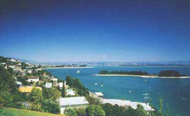
Nelson is a picturesque seaside city. Explore the city via a scenic drive, experience vantage points which offer panoramic views over to Tasman Bay and the surrounding region. This corner of New Zealand has attractions that range from deep forest to crazy caf� culture. The Nelson region is the northwestern half of the top of the South Island, the beautiful country lying between the northern edge of the Southern Alps and a great sweep of beaches.
Services listed here cover Nelson and it's surrounds.
Images and information placed above are from http://www.airportsnewzealand.com/ We thank www.airportsnewzealand.com for the data.
Runway 02R/20L 4420 x 148 feet
|
|||||||||||||||||||||||||||||||||||||||||||||||||||||||||||||||||||||||||||||||||||||||||||||||||||||||||||||||||||||||||||||||||||||||||||||||||||||||||||||||||||||||||||||||||||||||||||||||||||||||||||||||||||||||||||||||||||||||||||||||||||||||||||||||||||||||||||||||||||||||||||||||||||||||||||||||||||||||
| Runway 02R | |
|---|---|
| Surface | ASPHALT |
| True Heading | 042.0 |
| Latitude | -41.302722 41° 18' 09.80" S |
| Longitude | 173.219861 173° 13' 11.50" E |
| Elevation | 10.0 feet 3 meters |
| Slope | 0.1° |
| Landing Distance | 4420 feet 1347 meters |
| Takeoff Distance | 4420 feet 1347 meters |
| Lighting System | LIRL
REIL M PAPI |
| Runway 20L | |
|---|---|
| Surface | ASPHALT |
| True Heading | 222.0 |
| Latitude | -41.293556 41° 17' 36.80" S |
| Longitude | 173.230131 173° 13' 48.47" E |
| Elevation | 14.0 feet 4 meters |
| Slope | -0.1° |
| Landing Distance | 4420 feet 1347 meters |
| Takeoff Distance | 4420 feet 1347 meters |
| Lighting System | LIRL
M PAPI |
| Runway 02L | |
|---|---|
| Surface | GRASS OR EARTH NOT GRADED OR ROLLED. |
| True Heading | 042.0 |
| Latitude | 0.000000 - |
| Longitude | 0.000000 - |
| Elevation | 14.0 feet 4 meters |
| Slope | 0.1° |
| Landing Distance | 2398 feet 731 meters |
| Takeoff Distance | 2398 feet 731 meters |
| Runway 20R | |
|---|---|
| Surface | GRASS OR EARTH NOT GRADED OR ROLLED. |
| True Heading | 222.0 |
| Latitude | 0.000000 - |
| Longitude | 0.000000 - |
| Elevation | 17.0 feet 5 meters |
| Slope | -0.1° |
| Landing Distance | 2122 feet 647 meters |
| Takeoff Distance | 2398 feet 731 meters |
| Displaced Threshold Length | 276 feet 84 meters |
| Runway 06 | |
|---|---|
| Surface | GRASS OR EARTH NOT GRADED OR ROLLED. |
| True Heading | 083.0 |
| Latitude | 0.000000 - |
| Longitude | 0.000000 - |
| Elevation | 14.0 feet 4 meters |
| Slope | -0.1° |
| Landing Distance | 2200 feet 671 meters |
| Takeoff Distance | 2200 feet 671 meters |
| Runway 24 | |
|---|---|
| Surface | GRASS OR EARTH NOT GRADED OR ROLLED. |
| True Heading | 263.0 |
| Latitude | 0.000000 - |
| Longitude | 0.000000 - |
| Elevation | 12.0 feet 4 meters |
| Slope | 0.1° |
| Landing Distance | 2200 feet 671 meters |
| Takeoff Distance | 2200 feet 671 meters |
| Runway 17 | |
|---|---|
| Surface | GRASS OR EARTH NOT GRADED OR ROLLED. |
| True Heading | 187.0 |
| Latitude | 0.000000 - |
| Longitude | 0.000000 - |
| Landing Distance | 1970 feet 600 meters |
| Takeoff Distance | 1970 feet 600 meters |
| Runway 35 | |
|---|---|
| Surface | GRASS OR EARTH NOT GRADED OR ROLLED. |
| True Heading | 007.0 |
| Latitude | 0.000000 - |
| Longitude | 0.000000 - |
| Landing Distance | 1970 feet 600 meters |
| Takeoff Distance | 1970 feet 600 meters |
| NELSON | |||||
|---|---|---|---|---|---|
| Type | ID | Channel | Freq | Country | State |
| VOR-DME | NS | 111X | 116.4 | New Zealand | - |
| Latitude | Longitude | Airport |
| -41.301694 41° 18' 06.10" S |
173.222533 173° 13' 21.12" E |
NZNS |
The content above was published at Airports-Worldwide.com in 2004.
We don't guarantee the information is fresh and accurate. The data may be wrong or outdated.
For more up-to-date information please refer to other sources.

 |
|
Copyright 2004-2026 © by Airports-Worldwide.com, Vyshenskoho st. 36, Lviv 79010, Ukraine Legal Disclaimer |
 Operator:
Nelson Airport Limited
Operator:
Nelson Airport Limited