|
 |
|
||||
|
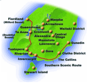
On 16 August 1994, Dunedin was the first to break the mould of a regional air terminal by becoming New Zealand�s first airport outside Auckland, Wellington or Christchurch to host a commercial international passenger flight. The return flight took Dunedin rugby fans to the now historic Bledisloe Cup rugby match in Sydney. The beauty of Dunedin means they can comfortably enjoy a round trip en route to Queenstown, seeing first class attractions on every road, in the same time it would take them to complete a �there and back� excursion from Christchurch. Less time on the road means more time to enjoy the sights and tastes of Central Otago, the Catlins, Milford Sound and the hundred and one other places on offer in the South Island�s Magnificent south. Dunedin International Airport has rental housing for let for a minimum period of 6 months ranging from $115 to $135 per week.
Dunedin International AirportPostal Address: 25 Miller Road, Momona Private Bag 1922 DUNEDIN Phone: +64 3 486 2879 Fax: +64 3 486 2813 E-mail: admin at dnairport co nz Images and information placed above are from http://www.dnairport.co.nz/ We thank http://www.dnairport.co.nz/ for the data.
Runway 03/21 6234 x 150 feet
|
||||||||||||||||||||||||||||||||||||||||||||||||||||||||||||||||||||||||||||||||||||||||||||||||||||||||||||||||||||||||||||||||||||||||||||||||||||||||||||||||||||||||||||||||||||||||||||||||||||||||||||||||||||||||||||||||||||||||||||||||||||||||||||||
| Runway 03 | |
|---|---|
| Surface | ASPHALT |
| True Heading | 056.0 |
| Latitude | -45.933925 45° 56' 02.13" S |
| Longitude | 170.187472 170° 11' 14.90" E |
| Elevation | 3.0 feet 1 meters |
| Slope | 0.0° |
| Landing Distance | 6234 feet 1900 meters |
| Takeoff Distance | 6234 feet 1900 meters |
| Lighting System | HIRL
X PAPI |
| Runway 21 | |
|---|---|
| Surface | ASPHALT |
| True Heading | 236.0 |
| Latitude | -45.924378 45° 55' 27.76" S |
| Longitude | 170.207786 170° 12' 28.03" E |
| Elevation | 4.0 feet 1 meters |
| Slope | 0.0° |
| Landing Distance | 6234 feet 1900 meters |
| Takeoff Distance | 6234 feet 1900 meters |
| Lighting System | HIRL
X PAPI |
| SWAMPY | |||||
|---|---|---|---|---|---|
| Type | ID | Channel | Freq | Country | State |
| NDB | SW | - | 338 | New Zealand | - |
| Latitude | Longitude | Airport |
| -45.796969 45° 47' 49.09" S |
170.477308 170° 28' 38.31" E |
NZDN |
| SWAMPY | |||||
|---|---|---|---|---|---|
| Type | ID | Channel | Freq | Country | State |
| VOR-DME | SW | 074X | 112.7 | New Zealand | - |
| Latitude | Longitude | Airport |
| -45.794519 45° 47' 40.27" S |
170.477194 170° 28' 37.90" E |
NZDN |
| HENLEY | |||||
|---|---|---|---|---|---|
| Type | ID | Channel | Freq | Country | State |
| NDB-DME | HL | 104X | 378 | New Zealand | - |
| Latitude | Longitude | Airport |
| -45.945883 45° 56' 45.18" S |
170.161931 170° 09' 42.95" E |
NZDN |
The content above was published at Airports-Worldwide.com in 2004.
We don't guarantee the information is fresh and accurate. The data may be wrong or outdated.
For more up-to-date information please refer to other sources.

 |
|
Copyright 2004-2026 © by Airports-Worldwide.com, Vyshenskoho st. 36, Lviv 79010, Ukraine Legal Disclaimer |
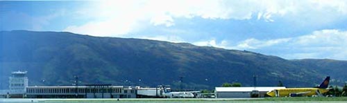
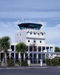
 Built in 1962 to cater for passengers of short haul aircraft, Dunedin Airport has adapted well to the modern era of air transport. From 100,000 passengers in 1963 to 520,000 in 1995 and 481,000 in 2000, with nearly 19000 aircraft movements in 2000. It is expected that by 2015, aircraft movements will reach 38,000 and well over 1 million passengers.