 |
|
About Us
Physical
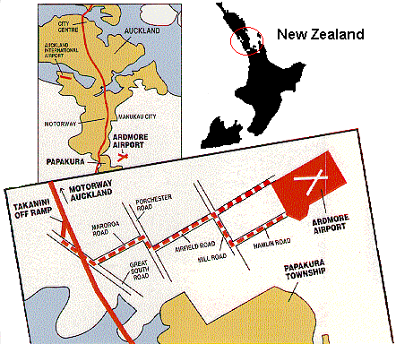
Ardmore Airport is located on the southern fringe of the Auckland urban area, some 33km south of the central business district, 11km east of Manukau City and 5km north-east of Papakura township.
Airside
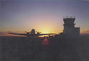
Ardmore has one sealed runway (Runway 03/21 1411m x 45m); and two grass runways (Runway 07/25 597m x 18m; and Runway 03/21 518m x 18m). There is a parallel taxiway to the south of the main sealed runway and two parallel taxiways connecting the northern side of the airfield with the main runway. Adjacent to these is an apron area by the Tower where there is also an enclosure for sustained aircraft engine testing.
Runway lighting is provided on the main sealed runway 03/21 for night operations and is Pilot Activated. The lighting also includes PAPI at both ends. More detailed information concerning the operational facilities is available in the Operations Manual.
Landside
Within the airport boundary there are 28 hangars, 31 offices/flying schools/charter services and 24 general buildings. At present the airport does not have a central airport terminal, and customers use the facilities offered by the individual service operators.
The Tenants
Currently 82 tenants operate at Ardmore. The range of aviation services offered by them is wide and varied, and includes:
- Fixed wing/helicopter servicing (26)
- Flight schools and charter (12)
- Fixed wing/helicopter sales (3)
- Private hangars/storage agents (26)
- Tenants offering "other" services (15)
There are some 330 aircraft permanently based at Ardmore.
Services
Ardmore Airport Limited (AAL) covers an extensive range of airfield services including:
- Night & Day general aviation operations
- Engine Testing Facility
- Airfield and facility planning and consultancy
- Airfield site development approvals and advice
- Operations Group meeting facilitation
- UNICOM Services (under contract)
- Aerodrome & Weather Information Broadcast (AWIB)
- 'Fly Friendly' Programme management
- Airfield lease management
Ardmore Utilities Limited (AUL), a subsidiary of AAL provides:
- Sewage reticulation for most airfield sites other than those sites on Airfield Road
- Water reticulation and management services
- Power reticulation is now the responsibility of Mercury
Address:
Ardmore Airport Ltd
McBride Lane
Ardmore Airport
Ardmore, Auckland
Private Bag 14
Papakura, Auckland
telephone: (09) 298-9544
fax: (09) 298-6213
Images and information placed above are from http://www.nzar.co.nz/
We thank
http://www.nzar.co.nz/
for the data.
| General Info
|
| Country |
New Zealand
|
| ICAO ID |
NZAR
|
| Time |
UTC+12(+13DT)
|
| Latitude |
-37.029722
37° 01' 47.00" S
|
| Longitude |
174.973333
174° 58' 24.00" E
|
| Elevation |
111 feet
34 meters
|
| Type |
Civil
|
| Magnetic Variation |
019° E (01/04)
|
| Operating Agency |
NEW ZEALAND CIVIL AVIATION AUTHORITY
|
| Near City |
Auckland
|
| Operating Hours |
NO OPERATING HOURS LISTED
|
| Communications
|
UNICOM
Opr 2000-0600Z++
|
118.1
|
| AWIB |
121.0
|
| FIS |
120.1
|
| CTAF |
118.1
|
| Communications Remarks |
|
| INFO |
For IFR acft on gnd ctc AUCKLAND CON
|
| Runways
|
| ID |
Dimensions |
Surface |
PCN |
ILS
|
| 03R/21L |
4630 x 98 feet
1411 x 30 meters |
ASPHALT |
014FDXT |
NO
|
| 03L/21R |
1700 x 59 feet
518 x 18 meters |
GRASS OR EARTH NOT GRADED OR ROLLED. |
- |
NO
|
| 07/25 |
1960 x 59 feet
597 x 18 meters |
GRASS OR EARTH NOT GRADED OR ROLLED. |
- |
NO
|
| Supplies/Equipment
|
| Fuel |
Jet A1, without icing nhibitor.
100/130 octane gasoline, leaded, MIL-L-5572F (GREEN)
|
| Remarks
|
| CAUTION |
Hills rising to 900' SE of arpt wo obst lgt. Bird haz. For acft over 12,500 lb Rwy 07L, 3780' avbl. Acft with lo prop clnc exer caution trns btn paved and grass rwy.
|
| FUEL |
(NC-100, A1)
|
| LGT |
Rwy 21L PAPI use proh unless estab on rwy cntrline due obst. ACTIVATE-Rwy 03R-21L-CTAF.
|
| MISC |
Arpt supervisor fone C(09) 298-9544. Fees.
|
| RSTD |
Rwy 03R-21L ngt opr proh for acft over 12,500 lb. Simultaneous parl opr on pavedand grass rwy only for acft blw 5950 lb VFR cond.
|
Runway 03R/21L
4630 x 98 feet
1411 x 30 meters
| Runway 03R
|
| Surface |
ASPHALT
|
| True Heading |
048.0
|
| Latitude |
-37.034833
37° 02' 05.40" S
|
| Longitude |
174.969061
174° 58' 08.62" E
|
| Elevation |
105.0 feet
32 meters
|
| Slope |
0.1°
|
| Landing Distance |
4285 feet
1306 meters
|
| Takeoff Distance |
4630 feet
1411 meters
|
| Displaced Threshold Length |
345 feet
105 meters
|
| Lighting System |
PCL
LIRL
PAPI |
| Runway 21L
|
| Surface |
ASPHALT
|
| True Heading |
228.0
|
| Latitude |
-37.025944
37° 01' 33.40" S
|
| Longitude |
174.979889
174° 58' 47.60" E
|
| Elevation |
108.0 feet
33 meters
|
| Slope |
-0.1°
|
| Landing Distance |
4263 feet
1299 meters
|
| Takeoff Distance |
4630 feet
1411 meters
|
| Displaced Threshold Length |
367 feet
112 meters
|
| Lighting System |
PCL
LIRL
PAPI |
Runway 03L/21R
1700 x 59 feet
518 x 18 meters
| Runway 03L
|
| Surface |
GRASS OR EARTH NOT GRADED OR ROLLED.
|
| True Heading |
048.0
|
| Latitude |
0.000000
-
|
| Longitude |
0.000000
-
|
| Landing Distance |
1700 feet
518 meters
|
| Takeoff Distance |
1700 feet
518 meters
|
| Runway 21R
|
| Surface |
GRASS OR EARTH NOT GRADED OR ROLLED.
|
| True Heading |
228.0
|
| Latitude |
0.000000
-
|
| Longitude |
0.000000
-
|
| Landing Distance |
1700 feet
518 meters
|
| Takeoff Distance |
1700 feet
518 meters
|
Runway 07/25
1960 x 59 feet
597 x 18 meters
| Runway 07
|
| Surface |
GRASS OR EARTH NOT GRADED OR ROLLED.
|
| True Heading |
092.0
|
| Latitude |
0.000000
-
|
| Longitude |
0.000000
-
|
| Elevation |
103.0 feet
31 meters
|
| Slope |
-5.3°
|
| Landing Distance |
1960 feet
597 meters
|
| Takeoff Distance |
1960 feet
597 meters
|
| Runway 25
|
| Surface |
GRASS OR EARTH NOT GRADED OR ROLLED.
|
| True Heading |
272.0
|
| Latitude |
0.000000
-
|
| Longitude |
0.000000
-
|
| Elevation |
0.0 feet
0 meters
|
| Slope |
5.3°
|
| Landing Distance |
1960 feet
597 meters
|
| Takeoff Distance |
1960 feet
597 meters
|
The content above was published at Airports-Worldwide.com in 2004.
We don't guarantee the information is fresh and accurate. The data may be wrong or outdated.
For more up-to-date information please refer to other sources.
|
 |


