|
|
Tinian International Airport
West Tinian Airport |
| IATA: TIQ – ICAO: PGWT – FAA LID: TNI |
| Summary |
| Airport type |
Public |
| Owner |
Commonwealth Ports Authority |
| Location |
Tinian |
| Elevation AMSL |
271 ft / 83 m |
| Coordinates |
14°59′57″N 145°37′10″E / 14.99917°N 145.61944°E / 14.99917; 145.61944 |
| Website |
cpa.gov.mp/tinapt.asp |
| Runways |
| Direction |
Length |
Surface |
| ft |
m |
| 8/26 |
8,600 |
2,621 |
Asphalt/Concrete |
| Statistics (2006) |
| Aircraft operations |
17,829 |
| Source: Federal Aviation Administration |
Tinian International Airport (IATA: TIQ, ICAO: PGWT, FAA LID: TNI), also known as West Tinian Airport, is a public airport located on Tinian Island in the United States Commonwealth of the Northern Mariana Islands. This airport is owned by Commonwealth Ports Authority.
Although most U.S. airports use the same three-letter location identifier for the FAA and IATA, Tinian International Airport is assigned TNI by the FAA and TIQ by the IATA (which assigned TNI to Satna, India). The airport's ICAO identifier is PGWT. Facilities and aircraft
Tinian International Airport covers an area of 1,416 acres (573 ha) which contains one paved runway (8/26) measuring 8,600 x 150 ft (2,621 x 46 m).
For 12-month period ending 31 March 2006 the airport had 17,829 aircraft operations, an average of 48 per day: 84% air taxi, 16% general aviation and <1% military.
Airlines and destinations
| Airlines |
Destinations |
| Freedom Air |
Saipan |
Role in World War II
- See also: Battle of Tinian
 | |
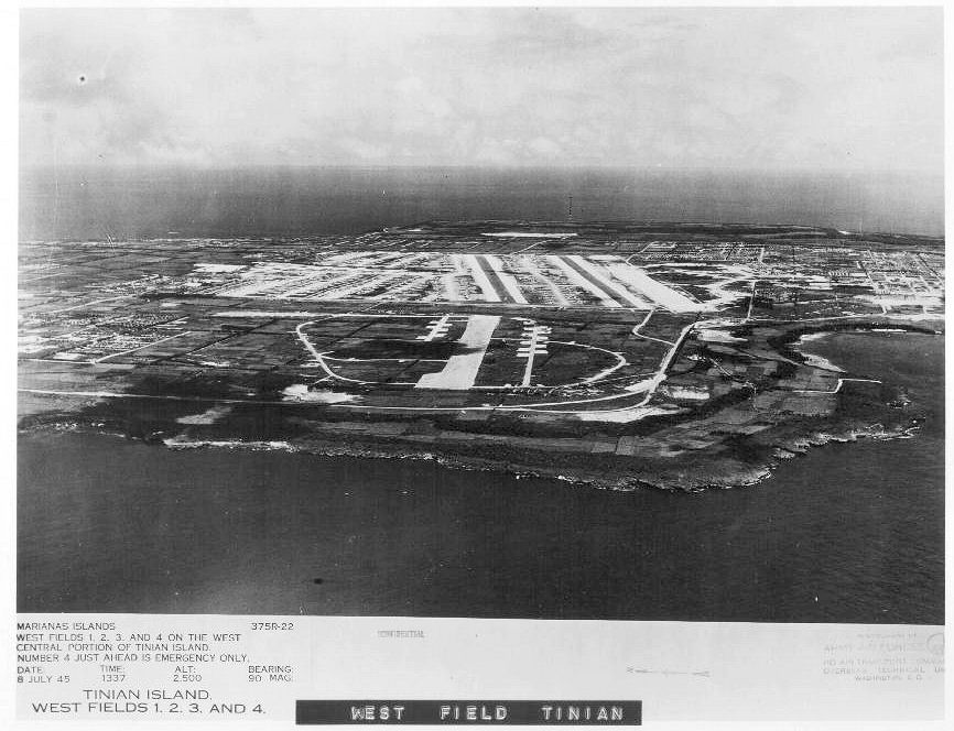
West Field, Tinian, 8 July 1945 |
Tinian, with its sister islands of the Marianas, had passed through Spanish and German hands prior to becoming a Protectorate of Japan following World War I. Under Japanese administration, Tinian was largely a sugar plantation. The island had three good airfields with a fourth under construction by the Japanese in 1944. Tinian International Airport originated as one of these airfields, having two parallel runways.
By mid-1944, the Americans had advanced inside the Japanese ring of defense in the Pacific Theater. On Tinian, the United States Army Air Forces could establish bases to conduct long-range strategic offensive air operations over the Japanese Home Islands with the new B-29 Superfortress, Assaulted on July 24, 1944 by United States Marines from Saipan, which had just been taken the previous month. After a fierce bombardment, the 4th Marine division landed. The Japanese were taken by surprise, and the offensive was regarded as one of the best-executed amphibious operation of the war.
Once under American control, a massive construction project was begun on the island, and the Japanese airfield was repaired and expanded, being named as West Field, or Gurguan Point Airfield due to its geographical location. West Field became operationally ready in the early spring of 1945, and the Twentieth Air Force XXI Bomber Command 58th Bombardment Wing was assigned to the field, being reassigned from Hijli Base Area, India.
The 58th Bomb Wing, with its subordinate units (40th, 444th, 462d and 468th Bombardment Groups) had been operating from airfields in India, and at times staging through fields in China since the summer of 1944 as part of Operation Matterhorn. The groups had struck such Japanese targets as transportation centers, naval installations, iron works, and aircraft plants in Burma, Thailand, China, Japan, the Netherlands East Indies, and Formosa. However, By late 1944, it was becoming apparent that B-29 operations against Japan staged out of bases in India and China were far too expensive in men and materials and would have to be stopped. In December 1944, the Joint Chiefs of Staff made the decision that the 58th Bombardment Wing's B-29s would be moved to the newly-captured islands in the Marianas in the central Pacific with airfields built on them to support their operations. The 58th Bomb Wing flew its last operations from India and China on 8 February 1945.
From West Field, B-29s of the wing initiated strategic bombardment operations directly against the Japanese Home Islands. Its units made daylight attacks from high altitudes on strategic targets, participated in nighttime incendiary raids on urban areas, and dropped mines in Japanese shipping lanes. After the Japanese surrender, groups of the 58th Bomb Wing dropped food and supplies to Allied prisoners of war in Japan, Korea, and Formosa, and took part in show of force missions. Beginning in September, the vast majority of its fleet of B-29 superfortreses were returned to the United States as part of "Operation Sunset". The 58th Bomb Wing returned to the United States on 15 November 1945, and its subordinate units were either inactivated or reassigned to other bases in Okinawa or returned to the United States.
With the departure of the USAAF, a part of the former wartime airfield has been used as a commercial airport and for general aviation use. In addition, the United States Navy leases the Northwest Field area north of the Airport for artillery training, and offers tours of the area when not being used for training.
The above content comes from Wikipedia and is published under free licenses – click here to read more.
| General Info
|
| Country |
Northern Mariana Islands
|
| ICAO ID |
PGWT
|
| Time |
UTC+10
|
| Latitude |
14.999203
14° 59' 57.13" N
|
| Longitude |
145.619350
145° 37' 09.66" E
|
| Elevation |
271 feet
83 meters
|
| Magnetic Variation |
001° E (01/06)
|
| Beacon |
Yes
|
| Operating Agency |
U.S.CIVIL AIRPORT WHEREIN PERMIT COVERS USE BY TRANSIT MILITARY AIRCRAFT
|
| Island Group |
Tinian I
|
| Operating Hours |
SEE REMARKS FOR OPERATING HOURS OR COMMUNICATIONS FOR POSSIBLE HOURS
|
| International Clearance Status |
Airport of Entry
|
| Communications
|
| SAIPAN RDO |
123.6
|
SAWRS
1500-0400Z.
|
SEE REMARKS
|
| CTAF |
123.6
|
| GUAM CNTR |
118.4
118.7
120.5
263.0
279.5
|
| Communications Remarks |
|
| CNTR |
290.5.
|
| Runways
|
| ID |
Dimensions |
Surface |
PCN |
ILS
|
| 08/26 |
8600 x 150 feet
2621 x 46 meters |
PART CONCRETE, PART ASPHALT, OR PART BITUMEN-BOUND MACADAM. |
- |
NO
|
| Navaids
|
| Type |
ID |
Name |
Channel |
Freq |
Distance From Field |
Bearing From Navaid
|
| NDB |
SN |
SAIPAN |
- |
312 |
8.5 NM |
216.9
|
| Remarks
|
| CSTMS/AG/IMG |
CSTMS, IMG avbl dur sked opr; OT PPR must be made with Chief, IMG, Saipan, C670-664-3131/32.
|
| LGT |
ACTIVATE-MIRL, REIL and PAPI Rwy 08-26-CTAF.
|
| MISC |
Crash-Fire-Rescue svc avbl 1730-0230Z and dur sked certified air carrier opr. Rwy grooved.
|
| OPR HOURS |
Opr 2100-0800Z, OT fone arpt mgr C670-433-9294/96.
|
| RSTD |
PPR fr Executive Drct, Commonwealth Ports Auth, Saipan, call C234-8315/8316 Mon-Fri. Maint ctc with Saipan FSS for tfc info. Arpt clsd to unsked air carrier op with more than 9 pax seats except 24hr PPR in writing to Arpt Mgr PO Box 501055,Saipan, MP 96950-1055. ARFF avbl 1600-0530Z.
|
The content above was published at Airports-Worldwide.com in 2010.
We don't guarantee the information is fresh and accurate. The data may be wrong or outdated.
For more up-to-date information please refer to other sources.
|
|