 |
|
De Kooy (Den Helder) Airport |
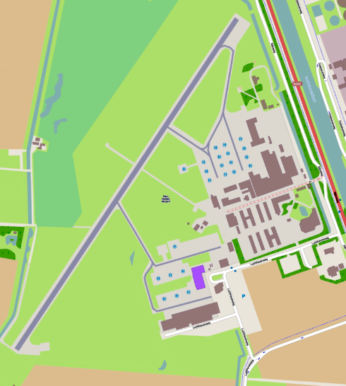
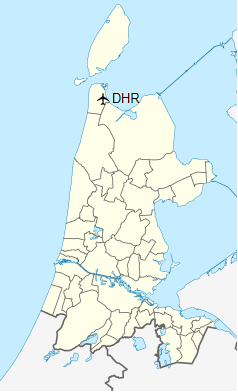
De Kooy Airfield (Dutch: Vliegveld De Kooy) (IATA: DHR, ICAO: EHKD) is an airfield 2.9 NM (5.4 km; 3.3 mi) south of Den Helder, Netherlands, named after the nearby hamlet De Kooy. It serves as both a civilian airport under the name Den Helder Airport and a naval airport under the name Maritiem Vliegkamp De Kooy (Dutch for Maritime Aviation Site De Kooy).
De Kooy Airfield
Vliegveld De Kooy
Den Helder Airport
Maritiem Vliegkamp De Kooy |
|
|
| Map |
|
|
| Summary |
| Airport type |
Military/Public |
| Operator |
Royal Netherlands Navy / Den Helder Airport CV |
| Location |
Den Helder, Netherlands |
| Elevation AMSL |
4 ft / 1 m |
| Coordinates |
52°55′25″N
004°46′50″E |
| Website |
www.DenHelderAirport.nl |
| Runways |
| Direction |
Length |
Surface |
| m |
ft |
| 03/21 |
1,275 |
4,183 |
Concrete |
|
|
De Kooy (Den Helder) Airport. |
|
De Kooy (Den Helder) Airport. |
|
De Kooy (Den Helder) Airport. |
Most movements on the De Kooy are made by helicopters, bringing workers to and from offshore oilrigs and naval helicopters such as the NH90 of the Royal Netherlands Navy. But fixed-wing aircraft visit and operate from the airport as well. Skyline Aviation operates from De Kooy, who mainly operate business aircraft but also do airwork such as aerial photography for both civilian and military contractors. Amongst their fleet of aircraft most noticeable are several Aero L-39 Albatros jets.
History
|
De Kooy (Den Helder) Airport. 1940. |
A pilot next to his downed Fokker D.XXI at De Kooy in May 1940 during the Battle of the Netherlands
The airport was constructed in 1918 for the Royal Dutch Navy, whose primary base was and still is located in Den Helder. A seaplane base already existed nearby on the south side of Texel however the navy required an airport for conventional aircraft as well. The base came under German control during the Second World War and was renamed Fliegerhorst De Kooy. It suffered heavy damage during the war, this despite the construction of heavy anti-aircraft defences in the area. After the war, the need for a naval air base in the area remained, and the airport was repaired. In 1960 a concrete runway was constructed, the base using a simple grass field prior to that. The retirement of the last aircraft carrier operated by the Dutch navy, the HNLMS Karel Doorman, in 1968, meant that the navy started to replace their fixed wing aircraft based at De Kooy with helicopters. In the 1980s, the need for offshore helicopter services for oilrigs in the North Sea resulted in the military sharing the base with civilian users.
Future
The oil fields in the North Sea will eventually be depleted and when that happens the airport would lose most of its helicopter movements and thus alternative markets are being looked at, such as business and holiday flights.
Airlines and destinations
There are currently no scheduled services to and from Den Helder. A service to Manchester and Norwich offered by Loganair was briefly operated in March 2013, however this route was terminated after only two weeks of service due to weak demand.
The above content comes from Wikipedia and is published under free licenses – click here to read more.
* * *
| General Info
|
| Country |
Netherlands
|
| ICAO ID |
EHKD
|
| Time |
UTC+1(+2DT)
|
| Latitude |
52.923353
52° 55' 24.07" N
|
| Longitude |
4.780625
004° 46' 50.25" E
|
| Elevation |
3 feet
1 meters
|
| Type |
Military
|
| Magnetic Variation |
000° W (01/06)
|
| Operating Agency |
MILITARY
|
| Near City |
Den Helder
|
| Operating Hours |
SEE REMARKS FOR OPERATING HOURS OR COMMUNICATIONS FOR POSSIBLE HOURS
|
| Daylight Saving Time |
Last Sunday in March to last Sunday in October
|
| Communications
|
TWR
Outside opr hr ctc DUTCH MIL info 132.35 or 264.325
|
120.125
234.8
122.1
257.8
|
GND
Opr HO
|
121.725
234.8
|
| FINAL |
123.3
234.15
|
| APP |
119.1
341.55
122.1
362.3
|
| Runways
|
| ID |
Dimensions |
Surface |
PCN |
ILS
|
| 04/22 |
4183 x 98 feet
1275 x 30 meters |
CONCRETE. |
021RBWT |
YES
|
| Navaids
|
| Type |
ID |
Name |
Channel |
Freq |
Distance From Field |
Bearing From Navaid
|
| VOR-DME |
HDR |
DEN HELDER |
102Y |
115.55 |
1.1 NM |
030.0
|
| Supplies/Equipment
|
| JASU |
DSA 150
28v DC 25 amp, 115/208v AC 15kva 400hz 3 phase 4 wire
ST-56
56kw 28v DC 700-1500 amp
|
| Remarks
|
| CAUTION |
Gldr, lgt acft and model flying act 1800Z++-SS Fri; SR-SS Sat, Sun and hol.
|
| CSTMS/IMG |
Avbl - 30 MIN PN.
|
| FUEL |
(NC100LL, A-1, J5)
|
| JASU |
1(DSA 150) 1(ST-56)
|
| OPR HOURS |
Opr 0600-2100Z++ Mon-Fri; 0600-1000Z++, 1400-1900Z++ Sat, Sun, and legal hol; OTPPR.
|
| RSTD |
PPR for civ and VFR tfc. Rpt LDA Rwy 04/22 is 3379'.
|
The content above was published at Airports-Worldwide.com in 2018.
We don't guarantee the information is fresh and accurate. The data may be wrong or outdated.
For more up-to-date information please refer to other sources.
|
|


 Airport")
 Airport")
 Airport")
 Airport")