|
|
Hosea Kutako Intl Airport |
| Hosea Kutako International Airport |
 |
| IATA: WDH – ICAO: FYWH |
| Summary |
| Airport type |
Public |
| Operator |
Namibian Civil Government |
| Location |
Windhoek |
| Elevation AMSL |
5,640 ft / 1,719 m |
| Coordinates |
22°29′12″S 17°27′45″E / 22.48667°S 17.4625°E / -22.48667; 17.4625Coordinates: 22°29′12″S 17°27′45″E / 22.48667°S 17.4625°E / -22.48667; 17.4625 |
| Website |
www.airports.com.na/hkia.php |
| Runways |
| Direction |
Length |
Surface |
| m |
ft |
| 08/26 |
4,532 |
14,869 |
Asphalt |
| 16/34 |
1,524 |
5,000 |
Asphalt |
Windhoek Hosea Kutako International Airport (IATA: WDH, ICAO: FYWH) is the main international airport serving the Namibian capital city of Windhoek. Located 45 km (28 mi) east of the city, it is Namibia's leading airport with international connections and handled 672,582 passengers in 2007. In 2009, the airport handled around 680,000 passengers, just over 4% down on the previous year when over 710,000 passengers were processed. The airport is named after Herero leader Hosea Kutako.
During South African adminisitration, the airport was named J.G. Strijdom Airport, after the Nationalist Prime Minister of South Africa. The main runway 08/26 is one of the longest in Africa and the World, at 4,532 m (14,869 ft).
Few, if any, domestic flights pass through Hosea Kutako Airport as those are predominantly handled at the smaller Windhoek Eros Airport. Public buses connect both airports to each other and to downtown Windhoek.
Airlines and destinations
| Airlines |
Destinations |
| Air Berlin |
Munich |
| Air Namibia |
Accra, Cape Town, Frankfurt, Johannesburg, Kumasi, Luanda, Lusaka, Maun, Victoria Falls, Walvis Bay |
| British Airways operated by Comair |
Johannesburg |
| South African Airways |
Johannesburg |
| South African Express |
Cape Town |
| TAAG Angola Airlines |
Luanda |
 | |
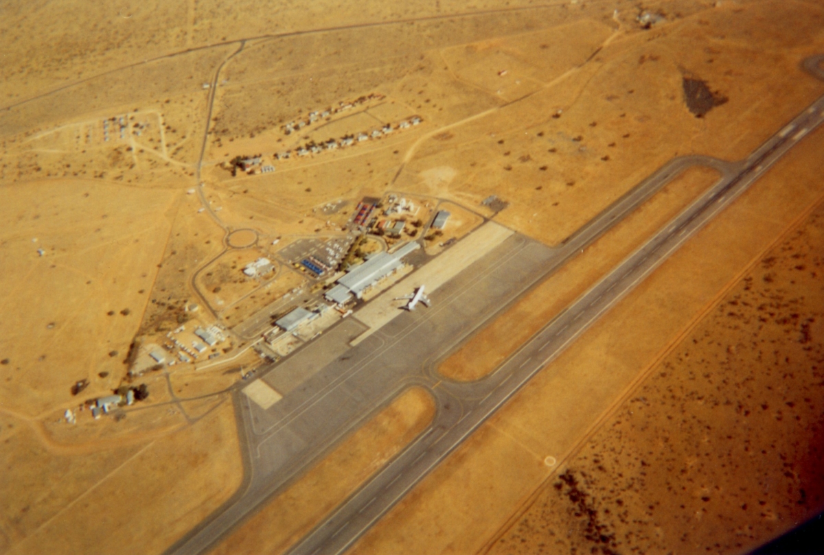
Hosea Kutako International Airport seen from the air |
The above content comes from Wikipedia and is published under free licenses – click here to read more.
| General Info
|
| Country |
Namibia
|
| ICAO ID |
FYWH
|
| Time |
UTC+1(+2DT)
|
| Latitude |
-22.479894
22° 28' 47.62" S
|
| Longitude |
17.470950
017° 28' 15.42" E
|
| Elevation |
5640 feet
1719 meters
|
| Type |
Civil
|
| Magnetic Variation |
013° W (01/06)
|
| Beacon |
Yes
|
| Operating Agency |
CIVIL GOVERNMENT, (LANDING FEES AND DIPLOMATIC CLEARANCE MAY BE REQUIRED)
|
| Near City |
Windhoek
|
| Operating Hours |
SEE REMARKS FOR OPERATING HOURS OR COMMUNICATIONS FOR POSSIBLE HOURS
|
| International Clearance Status |
Airport of Entry
|
| Communications
|
| WINDHOEK TWR |
118.1
|
| APRON |
121.9
|
ATIS
Opr 0600-1900Z
|
114.1
|
| WINDHOEK APP |
120.5
|
| Runways
|
| ID |
Dimensions |
Surface |
PCN |
ILS
|
| 08/26 |
15010 x 148 feet
4575 x 45 meters |
ASPHALT |
- |
YES
|
| 16/34 |
5000 x 98 feet
1524 x 30 meters |
ASPHALT |
- |
NO
|
| Navaids
|
| Type |
ID |
Name |
Channel |
Freq |
Distance From Field |
Bearing From Navaid
|
| VOR-DME |
WHV |
WINDHOEK |
092X |
114.5 |
At Field |
-
|
| NDB |
WH |
WINDHOEK |
- |
280 |
At Field |
-
|
| Supplies/Equipment
|
| Fuel |
Jet A1, without icing nhibitor.
|
The content above was published at Airports-Worldwide.com in 2010.
We don't guarantee the information is fresh and accurate. The data may be wrong or outdated.
For more up-to-date information please refer to other sources.
|
|