 |
|
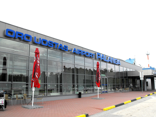
Palanga Airport
Palangos oro uostas |
 |
| IATA: PLQ – ICAO: EYPA |
| Summary |
| Airport type |
Public |
| Operator |
Lithuanian state |
| Location |
Palanga |
| Elevation AMSL |
33 ft / 10 m |
| Coordinates |
55°58′24″N 021°05′38″E / 55.97333°N 21.09389°E / 55.97333; 21.09389Coordinates: 55°58′24″N 021°05′38″E / 55.97333°N 21.09389°E / 55.97333; 21.09389 |
| Runways |
| Direction |
Length |
Surface |
| ft |
m |
| 01/19 |
7,478 |
2,280 |
Asphalt |
Palanga International Airport (IATA: PLQ, ICAO: EYPA) is an international airport located in the western part of Lithuania near the Baltic Sea. The airport accommodates routes flown by the Boeing 737, Saab 2000, Saab 340, CRJ-200, Jetstream-32, ATR 42, Yak-42 and similar mid-range aircraft. Since 1993, the number of passengers passing through the airport has increased annually. After Lithuania became a member of the EU, passengers in 2004 increased more than 60% in comparison with that of 2003.
Today Palanga's airport is the third largest in Lithuania after Vilnius International Airport and Kaunas International Airport in terms of passenger traffic. Over two hundred people are employed by the airport facilities. History
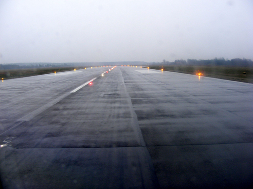 | |
Runway 01/19 as seen from the South end. LIH (high intensity) runway lighting installed in autumn 2007 |
Palanga Airport started operations in 1937 at a site 7 kilometers East of the current terminal, near the Palanga-Darbenai road. The Lithuanian Air Force pilots were trained there. In 1939, the first scheduled airline service in Lithuania began operating on Kaunas - Palanga route.
From 1940-1941, and again 1945-1963, the airport was used by the Air Force of the Soviet Union. It was during the post-war period when the new air strip and facilities at the current site first appeared. In 1963, the airport was converted into a civilian airport.
In 1991, Palanga Airport was re-registered as a national airport owned and run by the state. In 1997, the airport joined the major international aviation organization ACI (Airports Council International).
Between 1994 and 1997, the passenger terminal was renovated. Passenger services and luggage handling was fully modernized to comply with the requirements of the International Civil Aviation Organization (ICAO). Between 1994-1995, the flight control center was refurbished. In 1996-1997 the runway surface , and in 1998 the airport apron and taxiways were renovated.
In June-October 2007 the runway 01/19 was expanded to 2280x45 meters along with installation of LIH (high intensity) lighting and embedding the runway centerline lights.
Airlines and destinations
| Airlines |
Destinations |
| airBaltic |
Riga |
| Norwegian Air Shuttle |
Oslo-Gardermoen |
| Scandinavian Airlines |
Copenhagen |
Statistics
| Year |
Total Passengers |
| 2001 |
45 660 |
| 2002 |
45 971 |
| 2003 |
46 666 |
| 2004 |
76 020 |
| 2005 |
94 000 |
| 2006 |
110 828 |
| 2007 |
93 379 |
| 2008 |
101 586 |
| 2009 |
104 600 |
Public Transport Access
- Motorway A13 connects with Southern Palanga (7 km) and Klaipeda (32 km)
- A Public bus links the airport with Palanga coach bus station .
- Scandinavian Airlines passengers are serviced by shuttle bus operating between Klaipeda and the airport.
The above content comes from Wikipedia and is published under free licenses – click here to read more.
| General Info
|
| Country |
Lithuania
|
| ICAO ID |
EYPA
|
| Time |
UTC+2(+3DT)
|
| Latitude |
55.973228
55° 58' 23.62" N
|
| Longitude |
21.093856
021° 05' 37.88" E
|
| Elevation |
33 feet
10 meters
|
| Type |
Civil
|
| Magnetic Variation |
005° E (01/06)
|
| Operating Agency |
CIVIL GOVERNMENT, (LANDING FEES AND DIPLOMATIC CLEARANCE MAY BE REQUIRED)
|
| Operating Hours |
SEE REMARKS FOR OPERATING HOURS OR COMMUNICATIONS FOR POSSIBLE HOURS
|
| International Clearance Status |
Airport of Entry
|
| Daylight Saving Time |
Last Sunday in March to last Sunday in October
|
| Communications
|
TWR
Opr 0400-2000Z++.
|
118.3
|
RMP
Call AGENCY -
|
131.5
|
AWOS
Fone/fax C370 460 4 94 75.
|
SEE REMARKS
|
APP
Opr 0400-2000Z++.
|
124.3
|
| Communications Remarks |
|
| RMP |
Gnd handling and PAX svc.
|
| Runways
|
| ID |
Dimensions |
Surface |
PCN |
ILS
|
| 01/19 |
6562 x 131 feet
2000 x 40 meters |
ASPHALT |
048FBWT |
YES
|
| Navaids
|
| Type |
ID |
Name |
Channel |
Freq |
Distance From Field |
Bearing From Navaid
|
| NDB |
PN |
PALANGA |
- |
407 |
At Field |
-
|
| Supplies/Equipment
|
| Fuel |
Jet A1, without icing nhibitor.
100/130 MIL Spec, low lead, aviation gasoline (BLUE)
|
| Remarks
|
| CAUTION |
Extv bird haz immed vcnty of afld due migrations and breeding gnd.
|
| FLUID |
De-Ice
|
| FUEL |
(NC-100LL, A1)
|
| MISC |
Ldg fees. Class C Airspace eff ATS hrs, OT Class G.
|
| OPR HOURS |
Opr 0600-1500Z++ Mon-Fri. Fone C370 460 5 20 66, fax C370 460 5 20 20.
|
The content above was published at Airports-Worldwide.com in 2009.
We don't guarantee the information is fresh and accurate. The data may be wrong or outdated.
For more up-to-date information please refer to other sources.
|
|


